Property Record
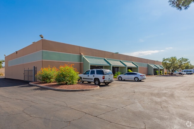
1950 E Watkins St, Phoenix, AZ 85034


Current Lease Availabilities
NEARBY LISTINGS FOR SALE OR LEASE
Property Detail
1950 E Watkins St
Phoenix-Mesa-Chandler, AZ
Agner Subdivision
115-27-018C
PT LY W/I SW4 SEC 15 DAF COM AT SW COR TR B PER MCR 112-15 TH S 88D 21 M W 555.07F TO PT ON E LN OF W 81F OF SD LT 10 & POB TH S 88D 21M W 51.04F TH N 3F TH S 88D 21M W 30.02F TO PT ON W LN SD LT 10 & E LN SW4 SD SEC 15 TH W 263.09F TH N 252.40F TO S
Warehouse
Maricopa
X
Arizona
04013C2220M
10
2025
1.75 AC
2025
S Airport N of Roeser
117200
Phoenix
22,551 SF
DEMOGRAPHICS near 1950 E Watkins St
1 mile
3 mile
5 mile
2024 Total Population
514
94,426
310,211
2029 Population
564
103,212
337,659
Pop Growth 2024-2029
+ 9.73%
+ 9.30%
+ 8.85%
Average Age
35
34
35
2024 Total Households
155
32,761
117,283
HH Growth 2024-2029
+ 9.68%
+ 9.93%
+ 9.23%
Median Household Inc
$35,417
$42,850
$55,948
Avg Household Size
3.30
2.70
2.50
2024 Avg HH Vehicles
2.00
2.00
2.00
Median Home Value
$318,182
$270,448
$331,415
Median Year Built
1967
1979
1977
Nearby Places
Map Layers
Map Styles
 Street
 Aerial
Transit
 Traffic
 Biking
Places
Listings with unknown addresses are not visible on the map
- Restaurants
- Banks
- Shops
- Fitness
- Groceries
PUBLIC TRANSPORTATION
AIRPORT
Phoenix Sky Harbor International
Drive
Walk
Distance
Phoenix Sky Harbor International
11 min
3.9 mi
Phoenix-Mesa Gateway
Drive
Walk
Distance
Phoenix-Mesa Gateway
41 min
29.3 mi
Nearby Properties
Address
Land Use
TOTAL SIZE
Lot Size
Zoning
Address
Land Use
TOTAL SIZE
Lot Size
Zoning
2,901,193 SF
20.73 AC
A-1
Address
Land Use
TOTAL SIZE
Lot Size
Zoning
997,436 SF
24.84 AC
DC
Address
Land Use
TOTAL SIZE
Lot Size
Zoning
24.15 AC
Address
Land Use
TOTAL SIZE
Lot Size
Zoning
2,568,761 SF
48.36 AC
C-C
Address
Land Use
TOTAL SIZE
Lot Size
Zoning
1,636,025 SF
16.50 AC
C-DT
Address
Land Use
TOTAL SIZE
Lot Size
Zoning
1,748,324 SF
29.35 AC
M-H
Address
Land Use
TOTAL SIZE
Lot Size
Zoning
1,949,842 SF
40 AC
I-1
Address
Land Use
TOTAL SIZE
Lot Size
Zoning
2,705,875 SF
133.42 AC
I-1
Address
Land Use
TOTAL SIZE
Lot Size
Zoning
577,883 SF
2.05 AC
C-DT
Address
Land Use
TOTAL SIZE
Lot Size
Zoning
111,886 SF
3.46 AC
C-G
Address
Land Use
TOTAL SIZE
Lot Size
Zoning
568,512 SF
6.99 AC
C-DT
Address
Land Use
TOTAL SIZE
Lot Size
Zoning
671,803 SF
2.99 AC
C-DT
Address
Land Use
TOTAL SIZE
Lot Size
Zoning
81,816 SF
7.95 AC
Address
Land Use
TOTAL SIZE
Lot Size
Zoning
833,326 SF
1.31 AC
C-DT
Address
Land Use
TOTAL SIZE
Lot Size
Zoning
940,067 SF
12.22 AC
DTCBIO
Address
Land Use
TOTAL SIZE
Lot Size
Zoning
536,452 SF
0.58 AC
C-DT
Address
Land Use
TOTAL SIZE
Lot Size
Zoning
981,015 SF
2.83 AC
C-DT
Address
Land Use
TOTAL SIZE
Lot Size
Zoning
94,162 SF
9.40 AC
I-2
Address
Land Use
TOTAL SIZE
Lot Size
Zoning
429,457 SF
9.41 AC
C-DT
Address
Land Use
TOTAL SIZE
Lot Size
Zoning
384,291 SF
2.68 AC
C-DT
Address
Land Use
TOTAL SIZE
Lot Size
Zoning
925,428 SF
86.02 AC
M-H
Address
Land Use
TOTAL SIZE
Lot Size
Zoning
Address
Land Use
TOTAL SIZE
Lot Size
Zoning
782,912 SF
1.12 AC
C-DT
Address
Land Use
TOTAL SIZE
Lot Size
Zoning
550,269 SF
2.05 AC
DTCBCORE
Address
Land Use
TOTAL SIZE
Lot Size
Zoning
727,848 SF
0.06 AC
C-DT
Address
Land Use
TOTAL SIZE
Lot Size
Zoning
569,100 SF
0.95 AC
C-DT
Address
Land Use
TOTAL SIZE
Lot Size
Zoning
4.76 AC
C-G
Address
Land Use
TOTAL SIZE
Lot Size
Zoning
222,983 SF
1.61 AC
C-DT
Address
Land Use
TOTAL SIZE
Lot Size
Zoning
462,201 SF
6.74 AC
I-1
Address
Land Use
TOTAL SIZE
Lot Size
Zoning
522,676 SF
264.16 AC
I-1
The World's #1 Commercial Real Estate Marketplace
Connect with us
© 2026 CoStar Group
The information above has been obtained from sources believed reliable. While we do not doubt its accuracy we have not verified it and make no guarantee, warranty or representation about it. It is your responsibility to independently confirm its accuracy and completeness. Any projections, opinions, assumptions, or estimates used are for example only and do not represent the current or future performance of the property. The value of this transaction to you depends on tax and other factors which should be evaluated by your tax, financial, and legal advisors. You and your advisors should conduct a careful, independent investigation of the property to determine to your satisfaction the suitability of the property for your needs.