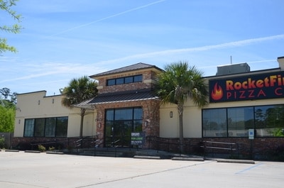
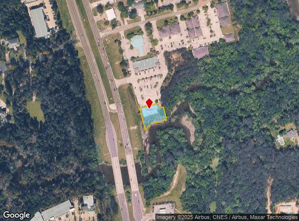
Property Record
1950 N Highway 190, Covington, LA 70433

NEARBY LISTINGS FOR SALE OR LEASE
Property Detail
1950 N Highway 190
Slidell-Mandeville-Covington, LA
Commercial N Hwy 190
32613
.439 ACS DESIG AS DE2 SEC 42 7 11 INST NO 1470936 INST NO 1547929 INST NO 1817011 ( ABITA VIEW CONDOMINIUM PARK ) INST NO 190
Commercialnec
St Tammany
ARE
Louisiana
2025
0.44 AC
2024
Mandeville/Covington
040608
New Orleans/Metairie/Kenner
6,168 SF
DEMOGRAPHICS near 1950 N Highway 190
1 mile
3 mile
5 mile
2024 Total Population
3,763
35,757
76,848
2029 Population
4,093
38,525
82,782
Pop Growth 2024-2029
+ 8.77%
+ 7.74%
+ 7.72%
Average Age
40
41
42
2024 Total Households
1,570
14,503
30,503
HH Growth 2024-2029
+ 8.66%
+ 7.71%
+ 7.72%
Median Household Inc
$83,705
$70,162
$73,674
Avg Household Size
2.40
2.40
2.40
2024 Avg HH Vehicles
2.00
2.00
2.00
Median Home Value
$242,279
$270,735
$300,487
Median Year Built
1999
1995
1996
Nearby Places
Map Layers
Map Styles
 Street
 Aerial
Transit
 Traffic
 Biking
Places
Listings with unknown addresses are not visible on the map
- Restaurants
- Banks
- Shops
- Fitness
- Groceries
PUBLIC TRANSPORTATION
AIRPORT
Louis Armstrong New Orleans International
Drive
Walk
Distance
Louis Armstrong New Orleans International
55 min
40.9 mi
SALE & LEASE HISTORY
LISTING DATE
SALE/LEASE

Sep 12, 2018
For Sale
Oct 12, 2017
For Lease
Feb 19, 2019
For Lease
Aug 29, 2017
For Lease
Apr 25, 2018
For Lease
Nearby Properties
Address
Land Use
TOTAL SIZE
Lot Size
Zoning
Address
Land Use
TOTAL SIZE
Lot Size
Zoning
515,547 SF
20.54 AC
Address
Land Use
TOTAL SIZE
Lot Size
Zoning
13.36 AC
Address
Land Use
TOTAL SIZE
Lot Size
Zoning
285,406 SF
Address
Land Use
TOTAL SIZE
Lot Size
Zoning
200,000 SF
0.28 AC
Address
Land Use
TOTAL SIZE
Lot Size
Zoning
5.10 AC
Address
Land Use
TOTAL SIZE
Lot Size
Zoning
262,080 SF
12.29 AC
Address
Land Use
TOTAL SIZE
Lot Size
Zoning
246,559 SF
42.43 AC
Address
Land Use
TOTAL SIZE
Lot Size
Zoning
86,167 SF
0.71 AC
Address
Land Use
TOTAL SIZE
Lot Size
Zoning
68,478 SF
6.64 AC
Address
Land Use
TOTAL SIZE
Lot Size
Zoning
171,138 SF
13.02 AC
Address
Land Use
TOTAL SIZE
Lot Size
Zoning
66,500 SF
4.35 AC
Address
Land Use
TOTAL SIZE
Lot Size
Zoning
102,470 SF
10.50 AC
Address
Land Use
TOTAL SIZE
Lot Size
Zoning
205,612 SF
23.60 AC
Address
Land Use
TOTAL SIZE
Lot Size
Zoning
147,611 SF
22 AC
Address
Land Use
TOTAL SIZE
Lot Size
Zoning
131,925 SF
2.02 AC
Address
Land Use
TOTAL SIZE
Lot Size
Zoning
38,976 SF
6.80 AC
Address
Land Use
TOTAL SIZE
Lot Size
Zoning
154,208 SF
21.28 AC
Address
Land Use
TOTAL SIZE
Lot Size
Zoning
92,535 SF
2.80 AC
Address
Land Use
TOTAL SIZE
Lot Size
Zoning
114,823 SF
4.57 AC
Address
Land Use
TOTAL SIZE
Lot Size
Zoning
124,002 SF
20.55 AC
Address
Land Use
TOTAL SIZE
Lot Size
Zoning
145,663 SF
16.70 AC
Address
Land Use
TOTAL SIZE
Lot Size
Zoning
86,688 SF
3.75 AC
Address
Land Use
TOTAL SIZE
Lot Size
Zoning
106,915 SF
20 AC
Address
Land Use
TOTAL SIZE
Lot Size
Zoning
114,727 SF
4.46 AC
Address
Land Use
TOTAL SIZE
Lot Size
Zoning
Address
Land Use
TOTAL SIZE
Lot Size
Zoning
48,866 SF
2.21 AC
Address
Land Use
TOTAL SIZE
Lot Size
Zoning
101,007 SF
6 AC
Address
Land Use
TOTAL SIZE
Lot Size
Zoning
126 SF
2.55 AC
Address
Land Use
TOTAL SIZE
Lot Size
Zoning
70,689 SF
2.90 AC
Address
Land Use
TOTAL SIZE
Lot Size
Zoning
97,331 SF
25.37 AC
The World's #1 Commercial Real Estate Marketplace
Connect with us
© 2026 CoStar Group
The information above has been obtained from sources believed reliable. While we do not doubt its accuracy we have not verified it and make no guarantee, warranty or representation about it. It is your responsibility to independently confirm its accuracy and completeness. Any projections, opinions, assumptions, or estimates used are for example only and do not represent the current or future performance of the property. The value of this transaction to you depends on tax and other factors which should be evaluated by your tax, financial, and legal advisors. You and your advisors should conduct a careful, independent investigation of the property to determine to your satisfaction the suitability of the property for your needs.