Property Record
1950 N Loop Ave, Casper, WY 82601
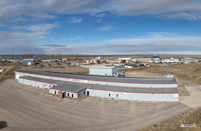

This Property Is For Sale
Property Detail
1950 N Loop Ave
Casper, WY
INTERSTATE IND PK LOT 23 COMMERCIAL
34-79-32-2-0-102800
Natrona
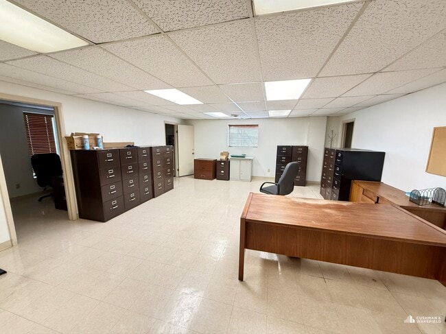
Warehouse
Wyoming
B and X Area of moderate flood hazard, usually the area between the limits of the 100-year and 500-year floods.
23
2024
4.25 AC
2025
I-25 Corridor/Casper
001401
Other Market Areas
33,550 SF
NEARBY LISTINGS FOR SALE OR LEASE
DEMOGRAPHICS near 1950 N Loop Ave
1 mile
3 mile
5 mile
2025 Total Population
90
19,513
61,482
2030 Population
92
19,835
62,066
Pop Growth 2025-2030
+ 2.22%
+ 1.65%
+ 0.95%
Average Age
41
41
40
2025 Total Households
34
8,931
25,684
HH Growth 2025-2030
+ 2.94%
+ 1.66%
+ 1.02%
Median Household Inc
$89,999
$54,412
$67,731
Avg Household Size
2.70
2.10
2.30
2025 Avg HH Vehicles
3.00
2.00
2.00
Median Home Value
$216,667
$204,434
$252,240
Median Year Built
1993
1956
1973
Nearby Places
Map Layers
Map Styles
 Street
 Aerial
Transit
 Traffic
 Biking
Places
Listings with unknown addresses are not visible on the map
- Restaurants
- Banks
- Shops
- Fitness
- Groceries
PUBLIC TRANSPORTATION
AIRPORT
Casper/Natrona County International
Drive
Walk
Distance
Casper/Natrona County International
26 min
13.2 mi
Freight Ports
Tulsa Port Of Catoosa
Drive
Walk
Distance
Tulsa Port Of Catoosa
997 min
980.8 mi
Nearby Properties
Address
Land Use
TOTAL SIZE
Lot Size
Zoning
Address
Land Use
TOTAL SIZE
Lot Size
Zoning
73,903 SF
31.44 AC
Address
Land Use
TOTAL SIZE
Lot Size
Zoning
156,457 SF
5.74 AC
Address
Land Use
TOTAL SIZE
Lot Size
Zoning
95,290 SF
0.57 AC
Address
Land Use
TOTAL SIZE
Lot Size
Zoning
99,524 SF
4.67 AC
Address
Land Use
TOTAL SIZE
Lot Size
Zoning
81,240 SF
5.86 AC
Address
Land Use
TOTAL SIZE
Lot Size
Zoning
166,099 SF
7.65 AC
Address
Land Use
TOTAL SIZE
Lot Size
Zoning
89,892 SF
2.75 AC
Address
Land Use
TOTAL SIZE
Lot Size
Zoning
88,739 SF
13.39 AC
Address
Land Use
TOTAL SIZE
Lot Size
Zoning
54,112 SF
3.52 AC
Address
Land Use
TOTAL SIZE
Lot Size
Zoning
40,414 SF
0.03 AC
Address
Land Use
TOTAL SIZE
Lot Size
Zoning
21,120 SF
16.73 AC
Address
Land Use
TOTAL SIZE
Lot Size
Zoning
76,420 SF
6.67 AC
Address
Land Use
TOTAL SIZE
Lot Size
Zoning
24,240 SF
16.47 AC
Address
Land Use
TOTAL SIZE
Lot Size
Zoning
82,800 SF
5.94 AC
Address
Land Use
TOTAL SIZE
Lot Size
Zoning
56,433 SF
3 AC
Address
Land Use
TOTAL SIZE
Lot Size
Zoning
45,297 SF
1.29 AC
Address
Land Use
TOTAL SIZE
Lot Size
Zoning
65,427 SF
2.16 AC
Address
Land Use
TOTAL SIZE
Lot Size
Zoning
25,200 SF
9.68 AC
Address
Land Use
TOTAL SIZE
Lot Size
Zoning
95,322 SF
2.01 AC
Address
Land Use
TOTAL SIZE
Lot Size
Zoning
63,950 SF
8.02 AC
Address
Land Use
TOTAL SIZE
Lot Size
Zoning
58,661 SF
2.49 AC
Address
Land Use
TOTAL SIZE
Lot Size
Zoning
55,953 SF
1.94 AC
Address
Land Use
TOTAL SIZE
Lot Size
Zoning
22,150 SF
5.49 AC
Address
Land Use
TOTAL SIZE
Lot Size
Zoning
19,695 SF
2.40 AC
Address
Land Use
TOTAL SIZE
Lot Size
Zoning
17,181 SF
0.38 AC
Address
Land Use
TOTAL SIZE
Lot Size
Zoning
84,524 SF
3.46 AC
Address
Land Use
TOTAL SIZE
Lot Size
Zoning
39,061 SF
3.61 AC
Address
Land Use
TOTAL SIZE
Lot Size
Zoning
44,582 SF
3.63 AC
Address
Land Use
TOTAL SIZE
Lot Size
Zoning
25,727 SF
1.45 AC
Address
Land Use
TOTAL SIZE
Lot Size
Zoning
63,811 SF
12.23 AC
The World's #1 Commercial Real Estate Marketplace
Connect with us
© 2026 CoStar Group
The information above has been obtained from sources believed reliable. While we do not doubt its accuracy we have not verified it and make no guarantee, warranty or representation about it. It is your responsibility to independently confirm its accuracy and completeness. Any projections, opinions, assumptions, or estimates used are for example only and do not represent the current or future performance of the property. The value of this transaction to you depends on tax and other factors which should be evaluated by your tax, financial, and legal advisors. You and your advisors should conduct a careful, independent investigation of the property to determine to your satisfaction the suitability of the property for your needs.