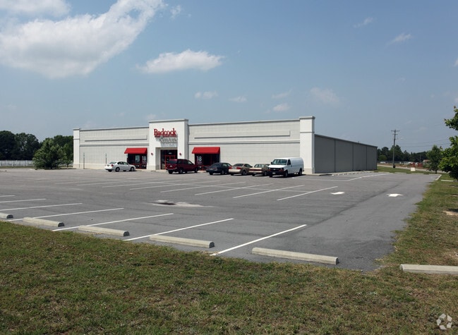
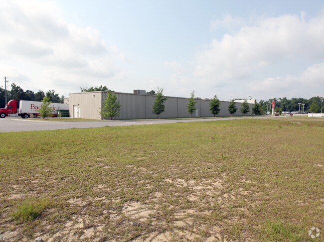
Property Record
1950 N Roberts Ave, Lumberton, NC 28358

NEARBY LISTINGS FOR SALE OR LEASE
Property Detail
1950 N Roberts Ave
1009-02-01102
Minor
Restaurantbuilding
AC N/E NC HWY 211 BADCOCK FURNITURE
X
Robeson
3720030200K
North Carolina
2025
2.26 AC
2025
Other Market Areas
961302
Lumberton, NC
29,928 SF
DEMOGRAPHICS near 1950 N Roberts Ave
1 Mile
3 Mile
5 Mile
2024 Total Population
5,940
22,762
34,405
2029 Population
5,996
23,150
34,915
Pop Growth 2024-2029
+ 0.94%
+ 1.70%
+ 1.48%
Average Age
39
39
39
2024 Total Households
2,381
8,839
13,106
HH Growth 2024-2029
+ 0.92%
+ 1.69%
+ 1.50%
Median Household Inc
$39,629
$39,429
$41,156
Avg Household Size
2.40
2.40
2.40
2024 Avg HH Vehicles
2.00
2.00
2.00
Median Home Value
$117,463
$119,251
$112,570
Median Year Built
1973
1977
1981
Nearby Places
Map Layers
Map Styles
 Street
 Aerial
- Restaurants
- Banks
- Shops
- Fitness
- Groceries
PUBLIC TRANSPORTATION
AIRPORT
Fayetteville Regional/Grannis Field
DRIVE
WALK
Distance
Fayetteville Regional/Grannis Field
35 min
28.1 mi
Freight Ports
Port of Wilmington
DRIVE
WALK
Distance
Port of Wilmington
106 min
73.6 mi
Nearby Properties
Address
Land Use
TOTAL SIZE
Lot Size
Zoning
Address
Land Use
TOTAL SIZE
Lot Size
Zoning
59,810 SF
7.69 AC
R7
Address
Land Use
TOTAL SIZE
Lot Size
Zoning
116,616 SF
10.18 AC
B6
Address
Land Use
TOTAL SIZE
Lot Size
Zoning
82,115 SF
39.22 AC
R15
Address
Land Use
TOTAL SIZE
Lot Size
Zoning
24,173 SF
44.32 AC
B3
Address
Land Use
TOTAL SIZE
Lot Size
Zoning
54,400 SF
69.94 AC
R20
Address
Land Use
TOTAL SIZE
Lot Size
Zoning
204,470 SF
18.21 AC
B4
Address
Land Use
TOTAL SIZE
Lot Size
Zoning
88,206 SF
19.07 AC
B4
Address
Land Use
TOTAL SIZE
Lot Size
Zoning
134,160 SF
0.26 AC
B6
Address
Land Use
TOTAL SIZE
Lot Size
Zoning
128,531 SF
22.20 AC
B4
Address
Land Use
TOTAL SIZE
Lot Size
Zoning
139,629 SF
19.05 AC
B4
Address
Land Use
TOTAL SIZE
Lot Size
Zoning
120,000 SF
17.10 AC
M2
Address
Land Use
TOTAL SIZE
Lot Size
Zoning
134,785 SF
17.82 AC
CUPB4
Address
Land Use
TOTAL SIZE
Lot Size
Zoning
36,329 SF
16.87 AC
R6
Address
Land Use
TOTAL SIZE
Lot Size
Zoning
60,906 SF
26.55 AC
Address
Land Use
TOTAL SIZE
Lot Size
Zoning
24,984 SF
41.13 AC
R11
Address
Land Use
TOTAL SIZE
Lot Size
Zoning
90,800 SF
36.65 AC
R20
Address
Land Use
TOTAL SIZE
Lot Size
Zoning
69,234 SF
3.18 AC
B5
Address
Land Use
TOTAL SIZE
Lot Size
Zoning
59,624 SF
2.19 AC
B4
Address
Land Use
TOTAL SIZE
Lot Size
Zoning
67,728 SF
1.50 AC
B1
Address
Land Use
TOTAL SIZE
Lot Size
Zoning
56,932 SF
1.37 AC
B4
Address
Land Use
TOTAL SIZE
Lot Size
Zoning
69,765 SF
9.51 AC
B4
Address
Land Use
TOTAL SIZE
Lot Size
Zoning
2,187 SF
18.75 AC
R3
Address
Land Use
TOTAL SIZE
Lot Size
Zoning
23,442 SF
7.22 AC
R6
Address
Land Use
TOTAL SIZE
Lot Size
Zoning
63,964 SF
5.65 AC
B5
Address
Land Use
TOTAL SIZE
Lot Size
Zoning
33,546 SF
4.97 AC
B4
Address
Land Use
TOTAL SIZE
Lot Size
Zoning
48,260 SF
2.95 AC
B5
Address
Land Use
TOTAL SIZE
Lot Size
Zoning
4,048 SF
12.73 AC
R3
Address
Land Use
TOTAL SIZE
Lot Size
Zoning
88,710 SF
1.11 AC
B1
Address
Land Use
TOTAL SIZE
Lot Size
Zoning
95,143 SF
7.55 AC
B4
Address
Land Use
TOTAL SIZE
Lot Size
Zoning
51,003 SF
8.49 AC
B3
The World's #1 Commercial Real Estate Marketplace
Connect with us
© 2025 CoStar Group
The information above has been obtained from sources believed reliable. While we do not doubt its accuracy we have not verified it and make no guarantee, warranty or representation about it. It is your responsibility to independently confirm its accuracy and completeness. Any projections, opinions, assumptions, or estimates used are for example only and do not represent the current or future performance of the property. The value of this transaction to you depends on tax and other factors which should be evaluated by your tax, financial, and legal advisors. You and your advisors should conduct a careful, independent investigation of the property to determine to your satisfaction the suitability of the property for your needs.