Property Record
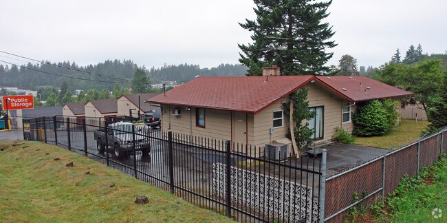
1950 Ne Riddell Rd, Bremerton, WA 98310


NEARBY LISTINGS FOR SALE OR LEASE
-
-
View all Bremerton listings for sale on LoopNet.com
Property Detail
1950 Ne Riddell Rd
362501-3-043-2007
PAR(1) THE E 5 ACS OF S 15 ACS OF SW1/4 SW1/4 EXC S 30FT FOR RIDDELL RD AND EXC E 145FT AS MEAS PLW E LN OF SW1/4 SW 1/4 AND EXC FDT BAT SE COR OF E 5 ACS OF S 15 ACS OF SD SW1/4 SW1/4 TH N ALG E LN THOF 30FT TH W 145FT TO TPOB TH N 100 FT TH W 115FT
Publicstorage
Kitsap
X
Washington
53035C0380F
43
2025
3.14 AC
2026
Central
091800
Bremerton/Silverdale
1,650 SF
Bremerton-Silverdale-Port Orchard, WA
DEMOGRAPHICS near 1950 Ne Riddell Rd
1 Mile
3 Mile
5 Mile
2024 Total Population
8,619
65,062
120,347
2029 Population
8,658
65,832
121,888
Pop Growth 2024-2029
+ 0.45%
+ 1.18%
+ 1.28%
Average Age
39
40
40
2024 Total Households
3,423
25,242
46,801
HH Growth 2024-2029
+ 0.41%
+ 1.31%
+ 1.41%
Median Household Inc
$65,147
$70,925
$76,179
Avg Household Size
2.50
2.40
2.40
2024 Avg HH Vehicles
2.00
2.00
2.00
Median Home Value
$368,330
$395,997
$433,407
Median Year Built
1976
1977
1981
Nearby Places
Map Layers
Map Styles
 Street
 Aerial
- Restaurants
- Banks
- Shops
- Fitness
- Groceries
PUBLIC TRANSPORTATION
AIRPORT
Seattle Paine Field International
DRIVE
WALK
Distance
Seattle Paine Field International
86 min
39.8 mi
Freight Ports
Port of Seattle
DRIVE
WALK
Distance
Port of Seattle
94 min
67.8 mi
Nearby Properties
Address
Land Use
TOTAL SIZE
Lot Size
Zoning
Address
Land Use
TOTAL SIZE
Lot Size
Zoning
329,553 SF
18.89 AC
UM
Address
Land Use
TOTAL SIZE
Lot Size
Zoning
0.13 AC
UH
Address
Land Use
TOTAL SIZE
Lot Size
Zoning
134,724 SF
6.85 AC
GC
Address
Land Use
TOTAL SIZE
Lot Size
Zoning
107,223 SF
12.76 AC
UM
Address
Land Use
TOTAL SIZE
Lot Size
Zoning
151,599 SF
5.44 AC
R-40
Address
Land Use
TOTAL SIZE
Lot Size
Zoning
132,092 SF
16.36 AC
UM
Address
Land Use
TOTAL SIZE
Lot Size
Zoning
2,672 SF
0.13 AC
UHUL
Address
Land Use
TOTAL SIZE
Lot Size
Zoning
214,450 SF
21.68 AC
R-40
Address
Land Use
TOTAL SIZE
Lot Size
Zoning
192,475 SF
16.26 AC
C
Address
Land Use
TOTAL SIZE
Lot Size
Zoning
1,716 SF
3.70 AC
UH
Address
Land Use
TOTAL SIZE
Lot Size
Zoning
80,228 SF
7.03 AC
GC
Address
Land Use
TOTAL SIZE
Lot Size
Zoning
1,344 SF
5.47 AC
R-40
Address
Land Use
TOTAL SIZE
Lot Size
Zoning
79,615 SF
1.25 AC
DSAP
Address
Land Use
TOTAL SIZE
Lot Size
Zoning
75,390 SF
4.46 AC
R-18
Address
Land Use
TOTAL SIZE
Lot Size
Zoning
122,799 SF
4.48 AC
R-40
Address
Land Use
TOTAL SIZE
Lot Size
Zoning
63,213 SF
4.15 AC
R-10
Address
Land Use
TOTAL SIZE
Lot Size
Zoning
106,087 SF
9.40 AC
UM
Address
Land Use
TOTAL SIZE
Lot Size
Zoning
150,790 SF
26.33 AC
C
Address
Land Use
TOTAL SIZE
Lot Size
Zoning
58,376 SF
6.68 AC
R-18
Address
Land Use
TOTAL SIZE
Lot Size
Zoning
64,584 SF
4.92 AC
R-40
Address
Land Use
TOTAL SIZE
Lot Size
Zoning
60,518 SF
2.62 AC
R-18
Address
Land Use
TOTAL SIZE
Lot Size
Zoning
55,412 SF
1.74 AC
R-18
Address
Land Use
TOTAL SIZE
Lot Size
Zoning
57,900 SF
3.90 AC
UH
Address
Land Use
TOTAL SIZE
Lot Size
Zoning
10.38 AC
Address
Land Use
TOTAL SIZE
Lot Size
Zoning
135,160 SF
1.14 AC
C
Address
Land Use
TOTAL SIZE
Lot Size
Zoning
84,193 SF
5.57 AC
DCC
Address
Land Use
TOTAL SIZE
Lot Size
Zoning
47,584 SF
3.76 AC
R-40
Address
Land Use
TOTAL SIZE
Lot Size
Zoning
126,276 SF
13.41 AC
UH
Address
Land Use
TOTAL SIZE
Lot Size
Zoning
44,220 SF
2.86 AC
R-40
Address
Land Use
TOTAL SIZE
Lot Size
Zoning
60,977 SF
0.47 AC
DSAP
The World's #1 Commercial Real Estate Marketplace
Connect with us
© 2026 CoStar Group
The information above has been obtained from sources believed reliable. While we do not doubt its accuracy we have not verified it and make no guarantee, warranty or representation about it. It is your responsibility to independently confirm its accuracy and completeness. Any projections, opinions, assumptions, or estimates used are for example only and do not represent the current or future performance of the property. The value of this transaction to you depends on tax and other factors which should be evaluated by your tax, financial, and legal advisors. You and your advisors should conduct a careful, independent investigation of the property to determine to your satisfaction the suitability of the property for your needs.