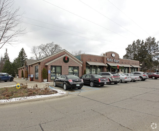
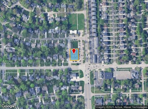
Property Record
1950 Southfield Rd, Birmingham, MI 48009

NEARBY LISTINGS FOR SALE OR LEASE
Property Detail
1950 Southfield Rd
Detroit-Warren-Dearborn, MI
J Lee Baker Co's Birmingham Hills Sub
19-35-481-030
T2N, R10E, SEC 35 J LEE BAKER CO'S BIRMINGHAM HILLS SUB S 1/2 OF LOT 304, ALSO ALL OF LOTS 305 TO 310 INCL 7-23-90 FR 025 &
Supermarket
Oakland
X
Michigan
26125C0536F
304-310
2024
0.31 AC
2024
Birmingham
153200
Detroit
13,312 SF
DEMOGRAPHICS near 1950 Southfield Rd
1 Mile
3 Mile
5 Mile
2024 Total Population
12,636
89,523
242,476
2029 Population
12,517
88,644
240,275
Pop Growth 2024-2029
(0.94%)
(0.98%)
(0.91%)
Average Age
42
42
42
2024 Total Households
5,216
38,725
105,238
HH Growth 2024-2029
(0.84%)
(0.97%)
(0.90%)
Median Household Inc
$150,988
$106,818
$95,409
Avg Household Size
2.40
2.30
2.20
2024 Avg HH Vehicles
2.00
2.00
2.00
Median Home Value
$543,799
$362,225
$334,582
Median Year Built
1957
1961
1963
Nearby Places
Map Layers
Map Styles
 Street
 Aerial
- Restaurants
- Banks
- Shops
- Fitness
- Groceries
PUBLIC TRANSPORTATION
COMMUTER RAIL
DRIVE
WALK
Distance
8 min
3.3 mi
DRIVE
WALK
Distance
12 min
5.7 mi
AIRPORT
Windsor International
DRIVE
WALK
Distance
Windsor International
52 min
28.3 mi
Detroit Metro Wayne County
DRIVE
WALK
Distance
Detroit Metro Wayne County
46 min
29.1 mi
Nearby Properties
Address
Land Use
TOTAL SIZE
Lot Size
Zoning
Address
Land Use
TOTAL SIZE
Lot Size
Zoning
399,735 SF
19.71 AC
B2
Address
Land Use
TOTAL SIZE
Lot Size
Zoning
350,140 SF
37.78 AC
RC
Address
Land Use
TOTAL SIZE
Lot Size
Zoning
224,766 SF
19.92 AC
B2
Address
Land Use
TOTAL SIZE
Lot Size
Zoning
111,030 SF
0.97 AC
BI
Address
Land Use
TOTAL SIZE
Lot Size
Zoning
149,395 SF
1.02 AC
BI
Address
Land Use
TOTAL SIZE
Lot Size
Zoning
143,160 SF
0.84 AC
BI
Address
Land Use
TOTAL SIZE
Lot Size
Zoning
15.32 AC
GEN BUS
Address
Land Use
TOTAL SIZE
Lot Size
Zoning
99,661 SF
0.62 AC
Address
Land Use
TOTAL SIZE
Lot Size
Zoning
236,140 SF
1.67 AC
BI
Address
Land Use
TOTAL SIZE
Lot Size
Zoning
83,244 SF
0.38 AC
Address
Land Use
TOTAL SIZE
Lot Size
Zoning
72,457 SF
5.60 AC
OFFICE SVC
Address
Land Use
TOTAL SIZE
Lot Size
Zoning
84,711 SF
5.05 AC
BI
Address
Land Use
TOTAL SIZE
Lot Size
Zoning
225,890 SF
10.10 AC
OM
Address
Land Use
TOTAL SIZE
Lot Size
Zoning
79,935 SF
1.02 AC
BI
Address
Land Use
TOTAL SIZE
Lot Size
Zoning
109,570 SF
0.68 AC
BI
Address
Land Use
TOTAL SIZE
Lot Size
Zoning
245,740 SF
1.06 AC
BI
Address
Land Use
TOTAL SIZE
Lot Size
Zoning
301,276 SF
13.58 AC
AI
Address
Land Use
TOTAL SIZE
Lot Size
Zoning
80,334 SF
0.57 AC
BI
Address
Land Use
TOTAL SIZE
Lot Size
Zoning
160,535 SF
9.52 AC
OM
Address
Land Use
TOTAL SIZE
Lot Size
Zoning
24.30 AC
GEN BUS
Address
Land Use
TOTAL SIZE
Lot Size
Zoning
56,867 SF
3.80 AC
BI
Address
Land Use
TOTAL SIZE
Lot Size
Zoning
212 SF
16.59 AC
RM
Address
Land Use
TOTAL SIZE
Lot Size
Zoning
254,457 SF
2.61 AC
B2
Address
Land Use
TOTAL SIZE
Lot Size
Zoning
52,787 SF
0.34 AC
BI
Address
Land Use
TOTAL SIZE
Lot Size
Zoning
149,135 SF
7.59 AC
OM
Address
Land Use
TOTAL SIZE
Lot Size
Zoning
183,090 SF
15.25 AC
RM
Address
Land Use
TOTAL SIZE
Lot Size
Zoning
152,827 SF
24 AC
B3
Address
Land Use
TOTAL SIZE
Lot Size
Zoning
73,689 SF
0.60 AC
BI
Address
Land Use
TOTAL SIZE
Lot Size
Zoning
882,000 SF
28.38 AC
OSC
Address
Land Use
TOTAL SIZE
Lot Size
Zoning
100,036 SF
1.32 AC
BI
The World's #1 Commercial Real Estate Marketplace
Connect with us
© 2025 CoStar Group
The information above has been obtained from sources believed reliable. While we do not doubt its accuracy we have not verified it and make no guarantee, warranty or representation about it. It is your responsibility to independently confirm its accuracy and completeness. Any projections, opinions, assumptions, or estimates used are for example only and do not represent the current or future performance of the property. The value of this transaction to you depends on tax and other factors which should be evaluated by your tax, financial, and legal advisors. You and your advisors should conduct a careful, independent investigation of the property to determine to your satisfaction the suitability of the property for your needs.