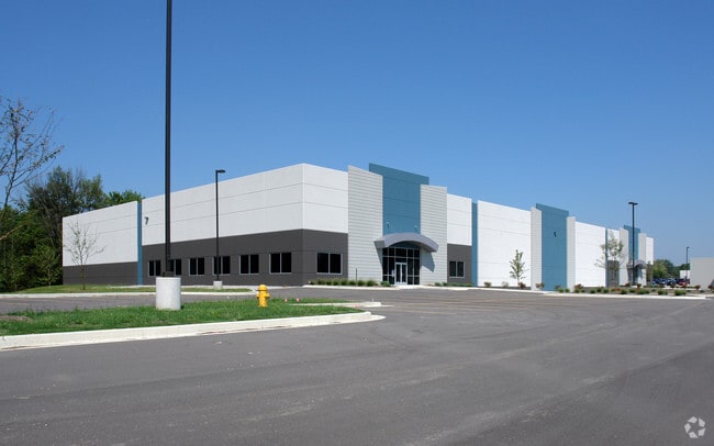
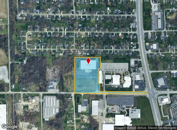
Property Record
1950 W Cook Rd, Fort Wayne, IN 46818
NEARBY LISTINGS FOR SALE OR LEASE
Property Detail
1950 W Cook Rd
02-07-10-382-001.000-073
S 733 OF E 1319 SW1/4 & OF SE1/4 W SR 3 EX TRACTS
Warehouse
Allen
AE
Indiana
18003C0170G
97.51 AC
2024
Outlying Allen County
2025
Fort Wayne
010603
Fort Wayne, IN
56,700 SF
DEMOGRAPHICS near 1950 W Cook Rd
1 Mile
3 Mile
5 Mile
2024 Total Population
3,314
39,916
121,040
2029 Population
3,467
41,446
126,395
Pop Growth 2024-2029
+ 4.62%
+ 3.83%
+ 4.42%
Average Age
42
39
38
2024 Total Households
1,434
16,436
50,045
HH Growth 2024-2029
+ 4.67%
+ 3.91%
+ 4.57%
Median Household Inc
$64,025
$66,051
$62,020
Avg Household Size
2.30
2.40
2.30
2024 Avg HH Vehicles
2.00
2.00
2.00
Median Home Value
$155,286
$166,158
$163,902
Median Year Built
1989
1989
1978
Nearby Places
Map Layers
Map Styles
 Street
 Aerial
- Restaurants
- Banks
- Shops
- Fitness
- Groceries
PUBLIC TRANSPORTATION
AIRPORT
Fort Wayne International
DRIVE
WALK
Distance
Fort Wayne International
27 min
18.2 mi
Freight Ports
Port of Toledo
DRIVE
WALK
Distance
Port of Toledo
143 min
109.3 mi
SALE & LEASE HISTORY
LISTING DATE
SALE/LEASE

Sep 25, 2016
For Lease
Sep 24, 2016
For Sale
Sep 10, 2018
For Lease
Sep 06, 2018
For Sale
Jun 21, 2017
For Sale
Jul 18, 2017
For Sale
Jan 24, 2017
For Sale
Apr 03, 2017
For Sale
Nearby Properties
Address
Land Use
TOTAL SIZE
Lot Size
Zoning
Address
Land Use
TOTAL SIZE
Lot Size
Zoning
460,252 SF
47.79 AC
Address
Land Use
TOTAL SIZE
Lot Size
Zoning
380,319 SF
430.55 AC
Address
Land Use
TOTAL SIZE
Lot Size
Zoning
5,681 SF
54.08 AC
Address
Land Use
TOTAL SIZE
Lot Size
Zoning
242,556 SF
17.18 AC
Address
Land Use
TOTAL SIZE
Lot Size
Zoning
324,784 SF
209.80 AC
Address
Land Use
TOTAL SIZE
Lot Size
Zoning
152,404 SF
27.41 AC
Address
Land Use
TOTAL SIZE
Lot Size
Zoning
75,843 SF
254.25 AC
Address
Land Use
TOTAL SIZE
Lot Size
Zoning
296,890 SF
269 AC
Address
Land Use
TOTAL SIZE
Lot Size
Zoning
342,303 SF
378.46 AC
Address
Land Use
TOTAL SIZE
Lot Size
Zoning
57,938 SF
34.15 AC
Address
Land Use
TOTAL SIZE
Lot Size
Zoning
285,314 SF
708.16 AC
Address
Land Use
TOTAL SIZE
Lot Size
Zoning
222,349 SF
322.70 AC
Address
Land Use
TOTAL SIZE
Lot Size
Zoning
85,484 SF
11.61 AC
Address
Land Use
TOTAL SIZE
Lot Size
Zoning
306,988 SF
21.57 AC
Address
Land Use
TOTAL SIZE
Lot Size
Zoning
158,885 SF
22.96 AC
Address
Land Use
TOTAL SIZE
Lot Size
Zoning
256,874 SF
242.10 AC
Address
Land Use
TOTAL SIZE
Lot Size
Zoning
218,078 SF
233.10 AC
Address
Land Use
TOTAL SIZE
Lot Size
Zoning
196,815 SF
327.58 AC
Address
Land Use
TOTAL SIZE
Lot Size
Zoning
120,652 SF
233.20 AC
Address
Land Use
TOTAL SIZE
Lot Size
Zoning
96,006 SF
18.24 AC
Address
Land Use
TOTAL SIZE
Lot Size
Zoning
86,016 SF
6.20 AC
Address
Land Use
TOTAL SIZE
Lot Size
Zoning
206,522 SF
130 AC
Address
Land Use
TOTAL SIZE
Lot Size
Zoning
154,701 SF
153.33 AC
Address
Land Use
TOTAL SIZE
Lot Size
Zoning
53,961 SF
23.05 AC
Address
Land Use
TOTAL SIZE
Lot Size
Zoning
102,744 SF
270 AC
Address
Land Use
TOTAL SIZE
Lot Size
Zoning
52,910 SF
49.05 AC
Address
Land Use
TOTAL SIZE
Lot Size
Zoning
247,233 SF
17.04 AC
Address
Land Use
TOTAL SIZE
Lot Size
Zoning
138,585 SF
184.50 AC
Address
Land Use
TOTAL SIZE
Lot Size
Zoning
153,893 SF
55.20 AC
Address
Land Use
TOTAL SIZE
Lot Size
Zoning
125,120 SF
69.03 AC
The World's #1 Commercial Real Estate Marketplace
Connect with us
© 2026 CoStar Group
The information above has been obtained from sources believed reliable. While we do not doubt its accuracy we have not verified it and make no guarantee, warranty or representation about it. It is your responsibility to independently confirm its accuracy and completeness. Any projections, opinions, assumptions, or estimates used are for example only and do not represent the current or future performance of the property. The value of this transaction to you depends on tax and other factors which should be evaluated by your tax, financial, and legal advisors. You and your advisors should conduct a careful, independent investigation of the property to determine to your satisfaction the suitability of the property for your needs.