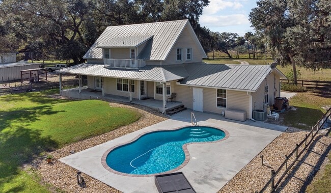
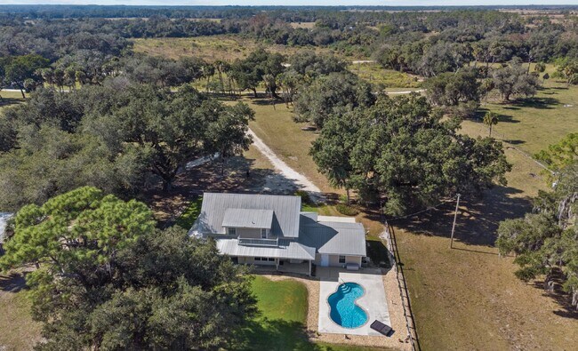
Property Record
19500 Armeda Rd, Alva, FL 33920

Save to a Folder
{{folder.Name}}
{{folder.ListingIds.length}} Properties
{{folder.ListingIds.length}} Property
Create a New Folder
Property Detail
19500 Armeda Rd
08-43-26-00-00006.0010
THE NW 1/4 OF THE NE 1/4 OF THE SE 1/4
Dairyfarm
Lee
AG-2
Florida
AE The base floodplain where base flood elevations are provided. AE Zones are now used on new format FIRMs instead of A1-A30 Zones.
1
2025
10.16 AC
2026
North Ft Myers
030100
Southwest Florida
4,963 SF
Cape Coral-Fort Myers, FL
NEARBY LISTINGS FOR SALE OR LEASE
DEMOGRAPHICS near 19500 Armeda Rd
1 mile
3 mile
5 mile
2025 Total Population
51
12,158
30,453
2030 Population
57
13,585
34,510
Pop Growth 2025-2030
+ 11.76%
+ 11.74%
+ 13.32%
Average Age
43
44
46
2025 Total Households
18
4,845
12,184
HH Growth 2025-2030
+ 11.11%
+ 11.31%
+ 12.88%
Median Household Inc
$70,499
$80,505
$92,143
Avg Household Size
2.40
2.40
2.40
2025 Avg HH Vehicles
3.00
2.00
2.00
Median Home Value
$805,555
$416,362
$457,752
Median Year Built
1994
1991
2006
Nearby Places
Map Layers
Map Styles
 Street
 Aerial
Layers
 Traffic
 Biking
Places
Listings with unknown addresses are not visible on the map
- Restaurants
- Banks
- Shops
- Fitness
- Groceries
PUBLIC TRANSPORTATION
AIRPORT
Southwest Florida International
Drive
Walk
Distance
Southwest Florida International
32 min
20.7 mi
Punta Gorda
Drive
Walk
Distance
Punta Gorda
36 min
26.1 mi
Freight Ports
Port Manatee
Drive
Walk
Distance
Port Manatee
116 min
97.8 mi
SALE & LEASE HISTORY
LISTING DATE
SALE/LEASE

Feb 10, 2021
For Sale
Nearby Properties
Address
Land Use
TOTAL SIZE
Lot Size
Zoning
Address
Land Use
TOTAL SIZE
Lot Size
Zoning
254,384 SF
42.57 AC
AG-2
Address
Land Use
TOTAL SIZE
Lot Size
Zoning
367,053 SF
17 AC
BOZD
Address
Land Use
TOTAL SIZE
Lot Size
Zoning
176,775 SF
98.93 AC
CF-3
Address
Land Use
TOTAL SIZE
Lot Size
Zoning
309.30 AC
MPD
Address
Land Use
TOTAL SIZE
Lot Size
Zoning
83,212 SF
12.96 AC
BOZD
Address
Land Use
TOTAL SIZE
Lot Size
Zoning
74,698 SF
8.33 AC
BOZD
Address
Land Use
TOTAL SIZE
Lot Size
Zoning
51,512 SF
128.26 AC
AG-2
Address
Land Use
TOTAL SIZE
Lot Size
Zoning
175.80 AC
Address
Land Use
TOTAL SIZE
Lot Size
Zoning
56,189 SF
5.51 AC
CC
Address
Land Use
TOTAL SIZE
Lot Size
Zoning
67.55 AC
Address
Land Use
TOTAL SIZE
Lot Size
Zoning
40,490 SF
1.95 AC
BOZD
Address
Land Use
TOTAL SIZE
Lot Size
Zoning
93,461 SF
5.75 AC
IM
Address
Land Use
TOTAL SIZE
Lot Size
Zoning
16.06 AC
BOZD
Address
Land Use
TOTAL SIZE
Lot Size
Zoning
18,224 SF
3.56 AC
BOZD
Address
Land Use
TOTAL SIZE
Lot Size
Zoning
0.96 AC
C-2
Address
Land Use
TOTAL SIZE
Lot Size
Zoning
11,223 SF
1.15 AC
BOZD
Address
Land Use
TOTAL SIZE
Lot Size
Zoning
85.73 AC
MPD
Address
Land Use
TOTAL SIZE
Lot Size
Zoning
Address
Land Use
TOTAL SIZE
Lot Size
Zoning
59,438 SF
8.95 AC
CPD
Address
Land Use
TOTAL SIZE
Lot Size
Zoning
31,657 SF
7.91 AC
BOZD
Address
Land Use
TOTAL SIZE
Lot Size
Zoning
83.23 AC
Address
Land Use
TOTAL SIZE
Lot Size
Zoning
69.91 AC
Address
Land Use
TOTAL SIZE
Lot Size
Zoning
9,017 SF
1.86 AC
CR
Address
Land Use
TOTAL SIZE
Lot Size
Zoning
25,884 SF
4.83 AC
CC
Address
Land Use
TOTAL SIZE
Lot Size
Zoning
8,850 SF
5.39 AC
AG-2
Address
Land Use
TOTAL SIZE
Lot Size
Zoning
36,371 SF
4.90 AC
CC
Address
Land Use
TOTAL SIZE
Lot Size
Zoning
5,963 SF
2.67 AC
C-1
Address
Land Use
TOTAL SIZE
Lot Size
Zoning
59.02 AC
Address
Land Use
TOTAL SIZE
Lot Size
Zoning
37.66 AC
Address
Land Use
TOTAL SIZE
Lot Size
Zoning
12,523 SF
2 AC
C-1
The World's #1 Commercial Real Estate Marketplace
Connect with us
© 2026 CoStar Group
The information above has been obtained from sources believed reliable. While we do not doubt its accuracy we have not verified it and make no guarantee, warranty or representation about it. It is your responsibility to independently confirm its accuracy and completeness. Any projections, opinions, assumptions, or estimates used are for example only and do not represent the current or future performance of the property. The value of this transaction to you depends on tax and other factors which should be evaluated by your tax, financial, and legal advisors. You and your advisors should conduct a careful, independent investigation of the property to determine to your satisfaction the suitability of the property for your needs.