Property Record
19505 N Sunrise Blvd, Surprise, AZ 85374


NEARBY LISTINGS FOR SALE OR LEASE
Property Detail
19505 N Sunrise Blvd
Phoenix-Mesa-Scottsdale, AZ
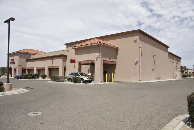
Osco Drug Store No 9306
232-32-971
OSCO DRUG STORE NO 9306 MCR 564-31
Regionalshoppingcenterormallwithanchorstore
Maricopa
X
Arizona
04013C1220L
2
2025
1.70 AC
2025
Surprise/North Peoria
040528
Phoenix
15,312 SF
DEMOGRAPHICS near 19505 N Sunrise Blvd
1 Mile
3 Mile
5 Mile
2024 Total Population
7,488
81,603
183,814
2029 Population
8,278
89,274
200,995
Pop Growth 2024-2029
+ 10.55%
+ 9.40%
+ 9.35%
Average Age
74
54
48
2024 Total Households
4,240
36,546
73,610
HH Growth 2024-2029
+ 10.59%
+ 9.84%
+ 9.58%
Median Household Inc
$70,921
$72,257
$75,624
Avg Household Size
1.70
2.20
2.40
2024 Avg HH Vehicles
2.00
2.00
2.00
Median Home Value
$430,074
$348,743
$353,645
Median Year Built
1999
2001
2002
Nearby Places
Map Layers
Map Styles
 Street
 Aerial
- Restaurants
- Banks
- Shops
- Fitness
- Groceries
PUBLIC TRANSPORTATION
AIRPORT
Phoenix Sky Harbor International
DRIVE
WALK
Distance
Phoenix Sky Harbor International
46 min
37.3 mi
Nearby Properties
Address
Land Use
TOTAL SIZE
Lot Size
Zoning
Address
Land Use
TOTAL SIZE
Lot Size
Zoning
290,294 SF
61.52 AC
PAD
Address
Land Use
TOTAL SIZE
Lot Size
Zoning
630,234 SF
27.51 AC
Address
Land Use
TOTAL SIZE
Lot Size
Zoning
575,121 SF
73.01 AC
PAD
Address
Land Use
TOTAL SIZE
Lot Size
Zoning
197,699 SF
40.78 AC
PAD
Address
Land Use
TOTAL SIZE
Lot Size
Zoning
548,535 SF
15.45 AC
C-T
Address
Land Use
TOTAL SIZE
Lot Size
Zoning
256,094 SF
49.15 AC
PAD
Address
Land Use
TOTAL SIZE
Lot Size
Zoning
5.46 AC
Address
Land Use
TOTAL SIZE
Lot Size
Zoning
296,463 SF
12.27 AC
M-H
Address
Land Use
TOTAL SIZE
Lot Size
Zoning
539,065 SF
33.30 AC
PAD
Address
Land Use
TOTAL SIZE
Lot Size
Zoning
382,188 SF
11.17 AC
M-H
Address
Land Use
TOTAL SIZE
Lot Size
Zoning
232,202 SF
27.32 AC
PAD
Address
Land Use
TOTAL SIZE
Lot Size
Zoning
104,685 SF
16.06 AC
PAD
Address
Land Use
TOTAL SIZE
Lot Size
Zoning
188,455 SF
17.72 AC
RH15
Address
Land Use
TOTAL SIZE
Lot Size
Zoning
106,244 SF
13.55 AC
PAD
Address
Land Use
TOTAL SIZE
Lot Size
Zoning
236,026 SF
6.66 AC
PAD
Address
Land Use
TOTAL SIZE
Lot Size
Zoning
104,102 SF
10.81 AC
PAD
Address
Land Use
TOTAL SIZE
Lot Size
Zoning
96,782 SF
15.66 AC
PAD
Address
Land Use
TOTAL SIZE
Lot Size
Zoning
104,619 SF
11.45 AC
PAD
Address
Land Use
TOTAL SIZE
Lot Size
Zoning
89,601 SF
19.92 AC
PAD
Address
Land Use
TOTAL SIZE
Lot Size
Zoning
203,123 SF
8.53 AC
PAD
Address
Land Use
TOTAL SIZE
Lot Size
Zoning
100,460 SF
11.63 AC
C-C
Address
Land Use
TOTAL SIZE
Lot Size
Zoning
65,711 SF
8.62 AC
PAD
Address
Land Use
TOTAL SIZE
Lot Size
Zoning
104,769 SF
10.41 AC
PAD
Address
Land Use
TOTAL SIZE
Lot Size
Zoning
92,051 SF
15 AC
PAD
Address
Land Use
TOTAL SIZE
Lot Size
Zoning
229,221 SF
19.51 AC
PAD
Address
Land Use
TOTAL SIZE
Lot Size
Zoning
296,540 SF
11 AC
Address
Land Use
TOTAL SIZE
Lot Size
Zoning
63,339 SF
4.60 AC
C-1
Address
Land Use
TOTAL SIZE
Lot Size
Zoning
69,504 SF
5.35 AC
PAD
Address
Land Use
TOTAL SIZE
Lot Size
Zoning
145,559 SF
14.98 AC
PAD
Address
Land Use
TOTAL SIZE
Lot Size
Zoning
103,080 SF
9.26 AC
PAD
The World's #1 Commercial Real Estate Marketplace
Connect with us
© 2026 CoStar Group
The information above has been obtained from sources believed reliable. While we do not doubt its accuracy we have not verified it and make no guarantee, warranty or representation about it. It is your responsibility to independently confirm its accuracy and completeness. Any projections, opinions, assumptions, or estimates used are for example only and do not represent the current or future performance of the property. The value of this transaction to you depends on tax and other factors which should be evaluated by your tax, financial, and legal advisors. You and your advisors should conduct a careful, independent investigation of the property to determine to your satisfaction the suitability of the property for your needs.