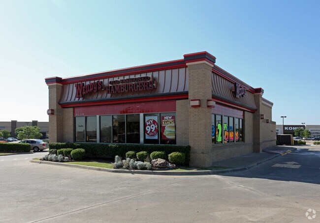
Property Record
1951 Eldorado Pkwy, Mckinney, TX 75069

Property Detail
1951 Eldorado Pkwy
Dallas-Fort Worth-Arlington, TX
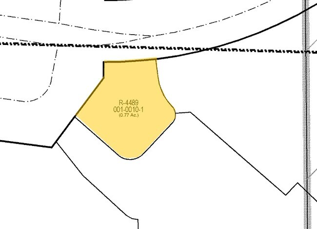
MCKINNEY MARKETPLACE ADDITION, BLK 1, LOT 1
R-4489-001-0010-1
COLLIN
Commercialnec
Texas
B and X Area of moderate flood hazard, usually the area between the limits of the 100-year and 500-year floods.
1
2025
0.77 AC
2025
McKinney
030801
Dallas/Ft Worth
3,244 SF
NEARBY LISTINGS FOR SALE OR LEASE
DEMOGRAPHICS near 1951 Eldorado Pkwy
1 mile
3 mile
5 mile
2025 Total Population
12,076
88,598
231,120
2030 Population
13,720
101,039
264,562
Pop Growth 2025-2030
+ 13.61%
+ 14.04%
+ 14.47%
Average Age
39
39
38
2025 Total Households
5,358
32,837
82,493
HH Growth 2025-2030
+ 13.90%
+ 14.27%
+ 14.69%
Median Household Inc
$76,761
$101,295
$117,689
Avg Household Size
2.20
2.60
2.70
2025 Avg HH Vehicles
1.00
2.00
2.00
Median Home Value
$456,267
$496,873
$519,049
Median Year Built
2003
2001
2006
Nearby Places
Map Layers
Map Styles
 Street
 Aerial
Transit
 Traffic
 Biking
Places
Listings with unknown addresses are not visible on the map
- Restaurants
- Banks
- Shops
- Fitness
- Groceries
PUBLIC TRANSPORTATION
AIRPORT
Dallas Love Field
Drive
Walk
Distance
Dallas Love Field
41 min
31.8 mi
Dallas-Fort Worth International
Drive
Walk
Distance
Dallas-Fort Worth International
40 min
34.2 mi
Nearby Properties
Address
Land Use
TOTAL SIZE
Lot Size
Zoning
Address
Land Use
TOTAL SIZE
Lot Size
Zoning
638,539 SF
42.76 AC
Address
Land Use
TOTAL SIZE
Lot Size
Zoning
472,185 SF
63.51 AC
AO
Address
Land Use
TOTAL SIZE
Lot Size
Zoning
162,000 SF
34 AC
L1
Address
Land Use
TOTAL SIZE
Lot Size
Zoning
495,048 SF
7.37 AC
Address
Land Use
TOTAL SIZE
Lot Size
Zoning
518,353 SF
28.51 AC
MF-M
Address
Land Use
TOTAL SIZE
Lot Size
Zoning
475,847 SF
16.34 AC
RG-18
Address
Land Use
TOTAL SIZE
Lot Size
Zoning
291,577 SF
69.24 AC
APTTOWNH
Address
Land Use
TOTAL SIZE
Lot Size
Zoning
370,860 SF
25.48 AC
Address
Land Use
TOTAL SIZE
Lot Size
Zoning
260,340 SF
18.64 AC
RG-18
Address
Land Use
TOTAL SIZE
Lot Size
Zoning
879,029 SF
50.26 AC
ML
Address
Land Use
TOTAL SIZE
Lot Size
Zoning
349,991 SF
13.53 AC
MF-M
Address
Land Use
TOTAL SIZE
Lot Size
Zoning
727,459 SF
48.83 AC
Address
Land Use
TOTAL SIZE
Lot Size
Zoning
725,223 SF
46.60 AC
Address
Land Use
TOTAL SIZE
Lot Size
Zoning
356,096 SF
19.50 AC
MF-M
Address
Land Use
TOTAL SIZE
Lot Size
Zoning
301,764 SF
20.88 AC
MF
Address
Land Use
TOTAL SIZE
Lot Size
Zoning
337,121 SF
9.39 AC
Address
Land Use
TOTAL SIZE
Lot Size
Zoning
321,982 SF
22.83 AC
SFR
Address
Land Use
TOTAL SIZE
Lot Size
Zoning
272,853 SF
17.32 AC
PD/ML
Address
Land Use
TOTAL SIZE
Lot Size
Zoning
1,708,448 SF
85.24 AC
Address
Land Use
TOTAL SIZE
Lot Size
Zoning
281,420 SF
9.43 AC
PD/ML
Address
Land Use
TOTAL SIZE
Lot Size
Zoning
173,393 SF
9.04 AC
MF-M
Address
Land Use
TOTAL SIZE
Lot Size
Zoning
201,484 SF
48.39 AC
PD/ML
Address
Land Use
TOTAL SIZE
Lot Size
Zoning
244,257 SF
8.01 AC
AG
Address
Land Use
TOTAL SIZE
Lot Size
Zoning
204,175 SF
10.57 AC
MF-H
Address
Land Use
TOTAL SIZE
Lot Size
Zoning
232,400 SF
13.32 AC
RG-18
Address
Land Use
TOTAL SIZE
Lot Size
Zoning
269,398 SF
6.05 AC
Address
Land Use
TOTAL SIZE
Lot Size
Zoning
193,037 SF
12.35 AC
MF-M
Address
Land Use
TOTAL SIZE
Lot Size
Zoning
131,417 SF
12 AC
AG
Address
Land Use
TOTAL SIZE
Lot Size
Zoning
304,565 SF
19.09 AC
COMM
Address
Land Use
TOTAL SIZE
Lot Size
Zoning
174,624 SF
10.05 AC
The World's #1 Commercial Real Estate Marketplace
Connect with us
© 2026 CoStar Group
The information above has been obtained from sources believed reliable. While we do not doubt its accuracy we have not verified it and make no guarantee, warranty or representation about it. It is your responsibility to independently confirm its accuracy and completeness. Any projections, opinions, assumptions, or estimates used are for example only and do not represent the current or future performance of the property. The value of this transaction to you depends on tax and other factors which should be evaluated by your tax, financial, and legal advisors. You and your advisors should conduct a careful, independent investigation of the property to determine to your satisfaction the suitability of the property for your needs.