Property Record
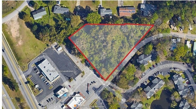
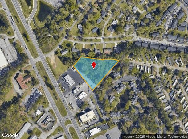
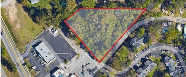
1951 Hawthorne Dr, Charleston, SC 29406
This Property Is For Sale
Current Lease Availabilities
NEARBY LISTINGS FOR SALE OR LEASE
Property Detail
1951 Hawthorne Dr
Charleston-North Charleston, SC
DESCRIPTION -LOT 4A SITE NAME -324 FT E SIDE 450 FT S AICHELE AVE SITE NAME -324 FT E SIDE 450 FT S AICHELE AVE
475-12-00-002
Charleston
Commercialacreage
South Carolina
X
4a
45019C0295K
1.94 AC
2025
North Charleston
2024
Charleston/N Charleston
003104
DEMOGRAPHICS near 1951 Hawthorne Dr
1 Mile
3 Mile
5 Mile
2024 Total Population
8,233
46,656
132,042
2029 Population
9,232
51,657
144,884
Pop Growth 2024-2029
+ 12.13%
+ 10.72%
+ 9.73%
Average Age
37
36
37
2024 Total Households
3,299
18,255
51,451
HH Growth 2024-2029
+ 12.16%
+ 10.52%
+ 9.53%
Median Household Inc
$47,358
$55,901
$53,376
Avg Household Size
2.50
2.50
2.40
2024 Avg HH Vehicles
2.00
2.00
2.00
Median Home Value
$184,655
$247,689
$209,320
Median Year Built
1978
1984
1984
Nearby Places
- Restaurants
- Banks
- Shops
- Fitness
- Groceries
PUBLIC TRANSPORTATION
AIRPORT
Charleston AFB/International
DRIVE
WALK
Distance
Charleston AFB/International
5 min
1.4 mi
Freight Ports
Georgia Ports - Savannah
DRIVE
WALK
Distance
Georgia Ports - Savannah
1 min
85.2 mi
Nearby Properties
Address
Land Use
TOTAL SIZE
Lot Size
Zoning
Address
Land Use
TOTAL SIZE
Lot Size
Zoning
313,920 SF
23.09 AC
HANAHAN -
Address
Land Use
TOTAL SIZE
Lot Size
Zoning
2,917 SF
11.76 AC
HANAHAN -
Address
Land Use
TOTAL SIZE
Lot Size
Zoning
202,154 SF
16.34 AC
Address
Land Use
TOTAL SIZE
Lot Size
Zoning
10,172 SF
12.76 AC
Address
Land Use
TOTAL SIZE
Lot Size
Zoning
7,200 SF
8.73 AC
Address
Land Use
TOTAL SIZE
Lot Size
Zoning
197,100 SF
34.14 AC
HANAHAN -
Address
Land Use
TOTAL SIZE
Lot Size
Zoning
302,400 SF
18.71 AC
HANAHAN -
Address
Land Use
TOTAL SIZE
Lot Size
Zoning
302,400 SF
23.70 AC
HANAHAN -
Address
Land Use
TOTAL SIZE
Lot Size
Zoning
350,760 SF
25.65 AC
HANAHAN -
Address
Land Use
TOTAL SIZE
Lot Size
Zoning
64,584 SF
10.92 AC
HANAHAN -
Address
Land Use
TOTAL SIZE
Lot Size
Zoning
137,576 SF
5 AC
HANAHAN -
Address
Land Use
TOTAL SIZE
Lot Size
Zoning
68,655 SF
9.48 AC
Address
Land Use
TOTAL SIZE
Lot Size
Zoning
4,320 SF
8.14 AC
HANAHAN -
Address
Land Use
TOTAL SIZE
Lot Size
Zoning
36,882 SF
5.80 AC
HANAHAN -
Address
Land Use
TOTAL SIZE
Lot Size
Zoning
105,666 SF
8.25 AC
Address
Land Use
TOTAL SIZE
Lot Size
Zoning
390,180 SF
20.76 AC
HANAHAN -
Address
Land Use
TOTAL SIZE
Lot Size
Zoning
36,912 SF
6.19 AC
HANAHAN -
Address
Land Use
TOTAL SIZE
Lot Size
Zoning
21,364 SF
7.71 AC
Address
Land Use
TOTAL SIZE
Lot Size
Zoning
92,800 SF
15.24 AC
HANAHAN -
Address
Land Use
TOTAL SIZE
Lot Size
Zoning
3,672 SF
3.62 AC
HANAHAN -
Address
Land Use
TOTAL SIZE
Lot Size
Zoning
10,560 SF
7.50 AC
Address
Land Use
TOTAL SIZE
Lot Size
Zoning
68,208 SF
21.38 AC
HANAHAN -
Address
Land Use
TOTAL SIZE
Lot Size
Zoning
7,176 SF
3.55 AC
HANAHAN -
Address
Land Use
TOTAL SIZE
Lot Size
Zoning
54,449 SF
10.56 AC
HANAHAN -
Address
Land Use
TOTAL SIZE
Lot Size
Zoning
199,300 SF
13.28 AC
Address
Land Use
TOTAL SIZE
Lot Size
Zoning
48,885 SF
5.02 AC
Address
Land Use
TOTAL SIZE
Lot Size
Zoning
126,385 SF
13.45 AC
Address
Land Use
TOTAL SIZE
Lot Size
Zoning
210,664 SF
8.87 AC
HANAHAN -
Address
Land Use
TOTAL SIZE
Lot Size
Zoning
9,691 SF
10.34 AC
Address
Land Use
TOTAL SIZE
Lot Size
Zoning
133.75 AC
MUC_DC
The World's #1 Commercial Real Estate Marketplace
Connect with us
© 2025 CoStar Group
The information above has been obtained from sources believed reliable. While we do not doubt its accuracy we have not verified it and make no guarantee, warranty or representation about it. It is your responsibility to independently confirm its accuracy and completeness. Any projections, opinions, assumptions, or estimates used are for example only and do not represent the current or future performance of the property. The value of this transaction to you depends on tax and other factors which should be evaluated by your tax, financial, and legal advisors. You and your advisors should conduct a careful, independent investigation of the property to determine to your satisfaction the suitability of the property for your needs.