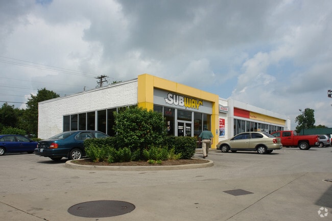
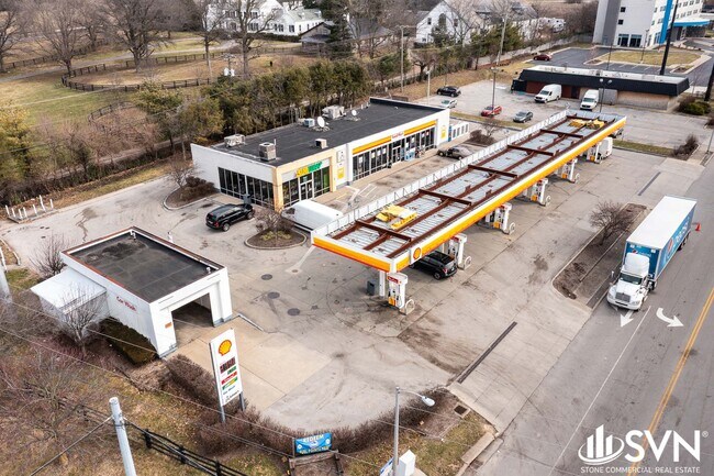
Property Record
1951 Stanton Way, Lexington, KY 40511

NEARBY LISTINGS FOR SALE OR LEASE
Property Detail
1951 Stanton Way
Lexington-Fayette, KY
Interstate Service Center
14851727
F-246 LOT 1; BOOK: 3636 PAGE: 203
Conveniencestore
Fayette
X
Kentucky
2100670126E
1
2025
1.08 AC
2025
East Lexington/Fayette
003802
Lexington/Fayette
4,922 SF
DEMOGRAPHICS near 1951 Stanton Way
1 Mile
3 Mile
5 Mile
2024 Total Population
1,834
33,351
108,132
2029 Population
1,874
33,666
108,808
Pop Growth 2024-2029
+ 2.18%
+ 0.94%
+ 0.63%
Average Age
36
38
37
2024 Total Households
738
13,226
44,402
HH Growth 2024-2029
+ 2.17%
+ 0.82%
+ 0.68%
Median Household Inc
$62,195
$61,387
$50,343
Avg Household Size
2.50
2.40
2.20
2024 Avg HH Vehicles
2.00
2.00
2.00
Median Home Value
$142,168
$172,497
$190,772
Median Year Built
1979
1983
1975
Nearby Places
Map Layers
Map Styles
 Street
 Aerial
- Restaurants
- Banks
- Shops
- Fitness
- Groceries
PUBLIC TRANSPORTATION
AIRPORT
Blue Grass
DRIVE
WALK
Distance
Blue Grass
19 min
11.2 mi
SALE & LEASE HISTORY
LISTING DATE
SALE/LEASE

Apr 03, 2024
For Lease
Nearby Properties
Address
Land Use
TOTAL SIZE
Lot Size
Zoning
Address
Land Use
TOTAL SIZE
Lot Size
Zoning
209,517 SF
39.97 AC
R-1B
Address
Land Use
TOTAL SIZE
Lot Size
Zoning
163,536 SF
117.26 AC
I-1
Address
Land Use
TOTAL SIZE
Lot Size
Zoning
Address
Land Use
TOTAL SIZE
Lot Size
Zoning
292,191 SF
19.74 AC
B-5P
Address
Land Use
TOTAL SIZE
Lot Size
Zoning
6,462 SF
332.36 AC
I-1
Address
Land Use
TOTAL SIZE
Lot Size
Zoning
70.44 AC
I-1
Address
Land Use
TOTAL SIZE
Lot Size
Zoning
210 SF
46.68 AC
M-1P
Address
Land Use
TOTAL SIZE
Lot Size
Zoning
16.93 AC
R-3
Address
Land Use
TOTAL SIZE
Lot Size
Zoning
441,100 SF
30 AC
I-1
Address
Land Use
TOTAL SIZE
Lot Size
Zoning
94,835 SF
21.09 AC
A-U
Address
Land Use
TOTAL SIZE
Lot Size
Zoning
Address
Land Use
TOTAL SIZE
Lot Size
Zoning
54,525 SF
25.78 AC
P-2
Address
Land Use
TOTAL SIZE
Lot Size
Zoning
3,242 SF
507.16 AC
A-R
Address
Land Use
TOTAL SIZE
Lot Size
Zoning
407,736 SF
29.54 AC
P-1
Address
Land Use
TOTAL SIZE
Lot Size
Zoning
187,120 SF
17.52 AC
I-1
Address
Land Use
TOTAL SIZE
Lot Size
Zoning
24,152 SF
924.40 AC
P-1
Address
Land Use
TOTAL SIZE
Lot Size
Zoning
210,498 SF
18.36 AC
I-1
Address
Land Use
TOTAL SIZE
Lot Size
Zoning
286,060 SF
P-2
Address
Land Use
TOTAL SIZE
Lot Size
Zoning
128,136 SF
P-2
Address
Land Use
TOTAL SIZE
Lot Size
Zoning
76,701 SF
14.98 AC
R-3
Address
Land Use
TOTAL SIZE
Lot Size
Zoning
13.50 AC
R-3
Address
Land Use
TOTAL SIZE
Lot Size
Zoning
7.01 AC
R-3
Address
Land Use
TOTAL SIZE
Lot Size
Zoning
172,215 SF
P-2
Address
Land Use
TOTAL SIZE
Lot Size
Zoning
26,470 SF
24.36 AC
I-1
Address
Land Use
TOTAL SIZE
Lot Size
Zoning
29,622 SF
8.30 AC
R-3
Address
Land Use
TOTAL SIZE
Lot Size
Zoning
73,114 SF
15 AC
P-1
Address
Land Use
TOTAL SIZE
Lot Size
Zoning
67,470 SF
15.01 AC
R-1C
Address
Land Use
TOTAL SIZE
Lot Size
Zoning
46,078 SF
32.17 AC
I-1
Address
Land Use
TOTAL SIZE
Lot Size
Zoning
154,374 SF
19 AC
I-1
Address
Land Use
TOTAL SIZE
Lot Size
Zoning
501,388 SF
29.93 AC
I-1
The World's #1 Commercial Real Estate Marketplace
Connect with us
© 2025 CoStar Group
The information above has been obtained from sources believed reliable. While we do not doubt its accuracy we have not verified it and make no guarantee, warranty or representation about it. It is your responsibility to independently confirm its accuracy and completeness. Any projections, opinions, assumptions, or estimates used are for example only and do not represent the current or future performance of the property. The value of this transaction to you depends on tax and other factors which should be evaluated by your tax, financial, and legal advisors. You and your advisors should conduct a careful, independent investigation of the property to determine to your satisfaction the suitability of the property for your needs.