Property Record
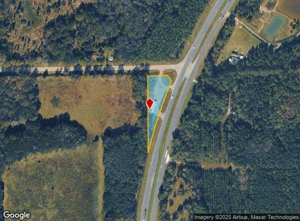
19510 Ne Us Highway 301, Waldo, FL 32694
NEARBY LISTINGS FOR SALE OR LEASE
Property Detail
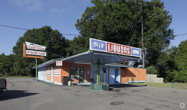
19510 Ne Us Highway 301
16919-000-000
Capstone Quarters
Bartavern
COM AT NW COR OF NE1/4 OF NE1/4 RUN S 1 DEG E 7 FT POB CONT S 1 DEG E 528.78 FT TO PT ON W/LY R/W OF SR-200 N 17 DEG E 516.75 FT N 34 DEG W 44.78 FT S 89 DEG W 138.02 FT TO POB OR 5200/0851
AE
Alachua
12007C0260E
Florida
2025
0.99 AC
2025
Gainesville
001908
Other Market Areas
2,045 SF
Gainesville, FL
DEMOGRAPHICS near 19510 Ne Us Highway 301
1 Mile
3 Mile
5 Mile
2024 Total Population
60
1,914
4,372
2029 Population
62
1,985
4,557
Pop Growth 2024-2029
+ 3.33%
+ 3.71%
+ 4.23%
Average Age
43
42
43
2024 Total Households
26
767
1,755
HH Growth 2024-2029
0.00%
+ 2.87%
+ 3.59%
Median Household Inc
$24,999
$42,313
$44,073
Avg Household Size
2.50
2.50
2.50
2024 Avg HH Vehicles
2.00
2.00
2.00
Median Home Value
$150,000
$145,022
$141,879
Median Year Built
1959
1983
1984
Nearby Places
Map Layers
Map Styles
 Street
 Aerial
- Restaurants
- Banks
- Shops
- Fitness
- Groceries
PUBLIC TRANSPORTATION
AIRPORT
Gainesville Regional
DRIVE
WALK
Distance
Gainesville Regional
24 min
15.0 mi
Freight Ports
Jacksonville Port
DRIVE
WALK
Distance
Jacksonville Port
74 min
58.0 mi
SALE & LEASE HISTORY
LISTING DATE
SALE/LEASE

Jun 29, 2023
For Sale
Jun 20, 2020
For Sale
Jul 31, 2017
For Sale
Apr 21, 2022
For Sale
Nearby Properties
Address
Land Use
TOTAL SIZE
Lot Size
Zoning
Address
Land Use
TOTAL SIZE
Lot Size
Zoning
1,288 SF
18.43 AC
W301
Address
Land Use
TOTAL SIZE
Lot Size
Zoning
24,076 SF
2 AC
W301
Address
Land Use
TOTAL SIZE
Lot Size
Zoning
38,426 SF
7.16 AC
CC
Address
Land Use
TOTAL SIZE
Lot Size
Zoning
30,134 SF
3.41 AC
RESMED
Address
Land Use
TOTAL SIZE
Lot Size
Zoning
9,645 SF
4 AC
W301
Address
Land Use
TOTAL SIZE
Lot Size
Zoning
24,000 SF
4.70 AC
COMM
Address
Land Use
TOTAL SIZE
Lot Size
Zoning
21,792 SF
39.70 AC
W301
Address
Land Use
TOTAL SIZE
Lot Size
Zoning
13,640 SF
1.84 AC
W301
Address
Land Use
TOTAL SIZE
Lot Size
Zoning
882 SF
79.56 AC
W301
Address
Land Use
TOTAL SIZE
Lot Size
Zoning
10,490 SF
206.67 AC
Address
Land Use
TOTAL SIZE
Lot Size
Zoning
191 SF
7 AC
W301
Address
Land Use
TOTAL SIZE
Lot Size
Zoning
3,247 SF
2.01 AC
LIND
Address
Land Use
TOTAL SIZE
Lot Size
Zoning
3,339 SF
2.71 AC
COMM
Address
Land Use
TOTAL SIZE
Lot Size
Zoning
8,500 SF
1.94 AC
CC
Address
Land Use
TOTAL SIZE
Lot Size
Zoning
8,373 SF
9.62 AC
Address
Land Use
TOTAL SIZE
Lot Size
Zoning
7,865 SF
0.80 AC
COMM
Address
Land Use
TOTAL SIZE
Lot Size
Zoning
12,000 SF
3.87 AC
Address
Land Use
TOTAL SIZE
Lot Size
Zoning
9,012 SF
1.09 AC
C0MM
Address
Land Use
TOTAL SIZE
Lot Size
Zoning
7,343 SF
1.99 AC
Address
Land Use
TOTAL SIZE
Lot Size
Zoning
5,584 SF
1.05 AC
BH
Address
Land Use
TOTAL SIZE
Lot Size
Zoning
1,699 SF
1.28 AC
W301
Address
Land Use
TOTAL SIZE
Lot Size
Zoning
3,598 SF
1.80 AC
COMM
Address
Land Use
TOTAL SIZE
Lot Size
Zoning
3,908 SF
10.25 AC
Address
Land Use
TOTAL SIZE
Lot Size
Zoning
12,531 SF
11.25 AC
Address
Land Use
TOTAL SIZE
Lot Size
Zoning
5,718 SF
10.79 AC
Address
Land Use
TOTAL SIZE
Lot Size
Zoning
1,440 SF
0.92 AC
C0MM
Address
Land Use
TOTAL SIZE
Lot Size
Zoning
14.65 AC
Address
Land Use
TOTAL SIZE
Lot Size
Zoning
2,647 SF
5.98 AC
Address
Land Use
TOTAL SIZE
Lot Size
Zoning
5,050 SF
9.90 AC
The World's #1 Commercial Real Estate Marketplace
Connect with us
© 2025 CoStar Group
The information above has been obtained from sources believed reliable. While we do not doubt its accuracy we have not verified it and make no guarantee, warranty or representation about it. It is your responsibility to independently confirm its accuracy and completeness. Any projections, opinions, assumptions, or estimates used are for example only and do not represent the current or future performance of the property. The value of this transaction to you depends on tax and other factors which should be evaluated by your tax, financial, and legal advisors. You and your advisors should conduct a careful, independent investigation of the property to determine to your satisfaction the suitability of the property for your needs.