Property Record
1952 Wingate Rd, Atlanta, GA 30341
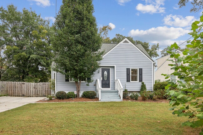
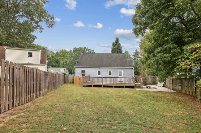
This Property Is For Sale
NEARBY LISTINGS FOR SALE OR LEASE
-
-
-
-
-
-
-
-
-
-
-
No Photo
-
-
-
-
View all Atlanta listings for sale on LoopNet.com
Property Detail
1952 Wingate Rd
Atlanta-Sandy Springs-Roswell, GA
Wingate Village
18-279-01-007
DeKalb
Sfr
Georgia
X
0.17 AC
13089C0018K
Chamblee/Dville/N D Hills
1,228 SF
Atlanta
DEMOGRAPHICS near 1952 Wingate Rd
1 Mile
3 Mile
5 Mile
2024 Total Population
9,257
110,941
314,605
2029 Population
9,710
112,800
320,641
Pop Growth 2024-2029
+ 4.89%
+ 1.68%
+ 1.92%
Average Age
37
37
38
2024 Total Households
4,439
46,334
139,566
HH Growth 2024-2029
+ 5.20%
+ 1.64%
+ 1.97%
Median Household Inc
$92,567
$100,188
$103,354
Avg Household Size
2.00
2.30
2.20
2024 Avg HH Vehicles
1.00
2.00
2.00
Median Home Value
$523,162
$609,659
$586,726
Median Year Built
2004
1987
1989
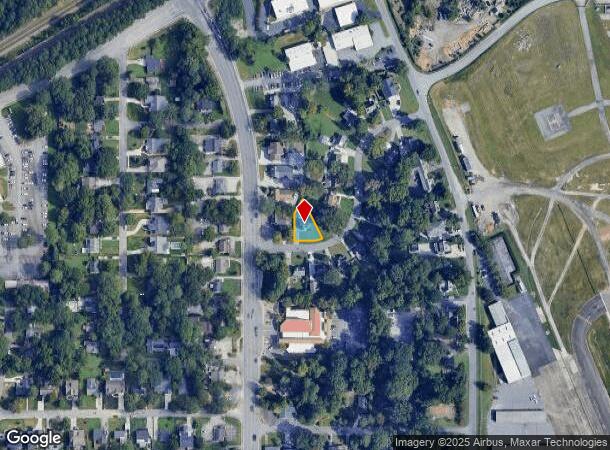
Nearby Places
Map Layers
Map Styles
 Street
 Aerial
- Restaurants
- Banks
- Shops
- Fitness
- Groceries
PUBLIC TRANSPORTATION
TRANSIT/SUBWAY
Chamblee (Gold Line - Metropolitan Atlanta Rapid Transit Authority (MARTA))
DRIVE
WALK
Distance
Chamblee (Gold Line - Metropolitan Atlanta Rapid Transit Authority (MARTA))
2 min
11 min
0.5 mi
COMMUTER RAIL
DRIVE
WALK
Distance
14 min
8.3 mi
AIRPORT
Hartsfield - Jackson Atlanta International
DRIVE
WALK
Distance
Hartsfield - Jackson Atlanta International
33 min
21.5 mi
Nearby Properties
Address
Land Use
TOTAL SIZE
Lot Size
Zoning
Address
Land Use
TOTAL SIZE
Lot Size
Zoning
705,518 SF
39.09 AC
M
Address
Land Use
TOTAL SIZE
Lot Size
Zoning
12,600 SF
508.30 AC
M
Address
Land Use
TOTAL SIZE
Lot Size
Zoning
299,993 SF
4.72 AC
I1
Address
Land Use
TOTAL SIZE
Lot Size
Zoning
701,195 SF
20.76 AC
X
Address
Land Use
TOTAL SIZE
Lot Size
Zoning
213,408 SF
6.35 AC
I1
Address
Land Use
TOTAL SIZE
Lot Size
Zoning
389,560 SF
4.01 AC
C1
Address
Land Use
TOTAL SIZE
Lot Size
Zoning
432,424 SF
3.87 AC
MC
Address
Land Use
TOTAL SIZE
Lot Size
Zoning
276,504 SF
3.40 AC
C1
Address
Land Use
TOTAL SIZE
Lot Size
Zoning
191,941 SF
3.02 AC
OCR
Address
Land Use
TOTAL SIZE
Lot Size
Zoning
140,183 SF
4.20 AC
OI
Address
Land Use
TOTAL SIZE
Lot Size
Zoning
257,989 SF
12.41 AC
OI
Address
Land Use
TOTAL SIZE
Lot Size
Zoning
157,133 SF
5.03 AC
M
Address
Land Use
TOTAL SIZE
Lot Size
Zoning
166,377 SF
7.56 AC
X
Address
Land Use
TOTAL SIZE
Lot Size
Zoning
283,784 SF
30.88 AC
RM100
Address
Land Use
TOTAL SIZE
Lot Size
Zoning
204,376 SF
14.23 AC
X
Address
Land Use
TOTAL SIZE
Lot Size
Zoning
366,276 SF
11.54 AC
RM-HD
Address
Land Use
TOTAL SIZE
Lot Size
Zoning
457,330 SF
20.49 AC
RM-HD
Address
Land Use
TOTAL SIZE
Lot Size
Zoning
345,441 SF
25.78 AC
C1
Address
Land Use
TOTAL SIZE
Lot Size
Zoning
144,380 SF
3.84 AC
X
Address
Land Use
TOTAL SIZE
Lot Size
Zoning
395,191 SF
2.78 AC
OIC
Address
Land Use
TOTAL SIZE
Lot Size
Zoning
267,983 SF
13 AC
X
Address
Land Use
TOTAL SIZE
Lot Size
Zoning
253,055 SF
2.65 AC
X
Address
Land Use
TOTAL SIZE
Lot Size
Zoning
214,915 SF
3.55 AC
Address
Land Use
TOTAL SIZE
Lot Size
Zoning
406,188 SF
4.43 AC
X
Address
Land Use
TOTAL SIZE
Lot Size
Zoning
325,232 SF
23.10 AC
X
Address
Land Use
TOTAL SIZE
Lot Size
Zoning
108,006 SF
11.23 AC
X
Address
Land Use
TOTAL SIZE
Lot Size
Zoning
169,476 SF
3 AC
MC
Address
Land Use
TOTAL SIZE
Lot Size
Zoning
536,151 SF
30.35 AC
X
Address
Land Use
TOTAL SIZE
Lot Size
Zoning
343,471 SF
8.90 AC
X
Address
Land Use
TOTAL SIZE
Lot Size
Zoning
287,657 SF
13.09 AC
X
The World's #1 Commercial Real Estate Marketplace
Connect with us
© 2026 CoStar Group
The information above has been obtained from sources believed reliable. While we do not doubt its accuracy we have not verified it and make no guarantee, warranty or representation about it. It is your responsibility to independently confirm its accuracy and completeness. Any projections, opinions, assumptions, or estimates used are for example only and do not represent the current or future performance of the property. The value of this transaction to you depends on tax and other factors which should be evaluated by your tax, financial, and legal advisors. You and your advisors should conduct a careful, independent investigation of the property to determine to your satisfaction the suitability of the property for your needs.