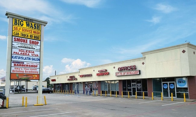
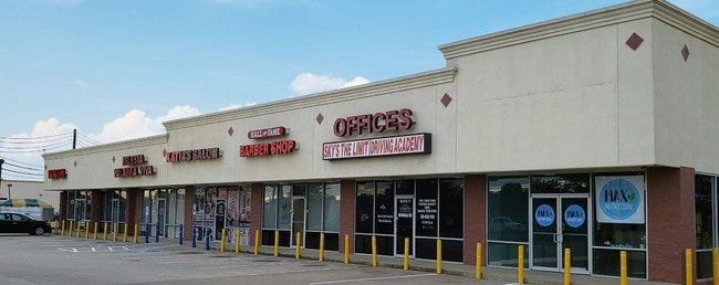
Property Record
19540 Clay Rd, Katy, TX 77449

Property Detail
19540 Clay Rd
1150540030071
RES A BLK 3 CYPRESS MEADOW SEC 2
Stripcommercialcenter
HARRIS
B and X Area of moderate flood hazard, usually the area between the limits of the 100-year and 500-year floods.
Texas
2024
1.01 AC
2025
Far Katy North
542104
Houston
13,876 SF
Houston-Pasadena-The Woodlands, TX
NEARBY LISTINGS FOR SALE OR LEASE
DEMOGRAPHICS near 19540 Clay Rd
1 mile
3 mile
5 mile
2025 Total Population
20,560
156,725
335,013
2030 Population
21,809
166,862
357,295
Pop Growth 2025-2030
+ 6.07%
+ 6.47%
+ 6.65%
Average Age
36
35
36
2025 Total Households
5,952
47,779
106,766
HH Growth 2025-2030
+ 6.25%
+ 6.69%
+ 6.83%
Median Household Inc
$90,772
$85,993
$86,333
Avg Household Size
3.40
3.20
3.10
2025 Avg HH Vehicles
2.00
2.00
2.00
Median Home Value
$265,087
$263,759
$275,310
Median Year Built
2002
2003
2001
Nearby Places
Map Layers
Map Styles
 Street
 Aerial
Layers
 Traffic
 Biking
Places
Listings with unknown addresses are not visible on the map
- Restaurants
- Banks
- Shops
- Fitness
- Groceries
PUBLIC TRANSPORTATION
AIRPORT
George Bush Intcntl/Houston
Drive
Walk
Distance
George Bush Intcntl/Houston
44 min
32.8 mi
William P Hobby
Drive
Walk
Distance
William P Hobby
57 min
38.0 mi
Freight Ports
Port of Houston
Drive
Walk
Distance
Port of Houston
51 min
34.8 mi
SALE & LEASE HISTORY
LISTING DATE
SALE/LEASE

Sep 20, 2022
For Lease
Oct 17, 2019
For Sale
Nov 08, 2017
For Sale
Apr 12, 2017
For Lease
Nearby Properties
Address
Land Use
TOTAL SIZE
Lot Size
Zoning
Address
Land Use
TOTAL SIZE
Lot Size
Zoning
439,347 SF
13.50 AC
Address
Land Use
TOTAL SIZE
Lot Size
Zoning
417,092 SF
17.58 AC
Address
Land Use
TOTAL SIZE
Lot Size
Zoning
375,486 SF
12.36 AC
Address
Land Use
TOTAL SIZE
Lot Size
Zoning
341,844 SF
16.71 AC
Address
Land Use
TOTAL SIZE
Lot Size
Zoning
343,605 SF
11.90 AC
Address
Land Use
TOTAL SIZE
Lot Size
Zoning
347,834 SF
15.25 AC
Address
Land Use
TOTAL SIZE
Lot Size
Zoning
272,033 SF
12.74 AC
Address
Land Use
TOTAL SIZE
Lot Size
Zoning
335,899 SF
12.62 AC
Address
Land Use
TOTAL SIZE
Lot Size
Zoning
331,263 SF
11.36 AC
Address
Land Use
TOTAL SIZE
Lot Size
Zoning
266,532 SF
6.45 AC
Address
Land Use
TOTAL SIZE
Lot Size
Zoning
284,321 SF
10.54 AC
Address
Land Use
TOTAL SIZE
Lot Size
Zoning
214,347 SF
30.70 AC
Address
Land Use
TOTAL SIZE
Lot Size
Zoning
236,406 SF
11.40 AC
Address
Land Use
TOTAL SIZE
Lot Size
Zoning
363,880 SF
17.32 AC
Address
Land Use
TOTAL SIZE
Lot Size
Zoning
305,624 SF
Address
Land Use
TOTAL SIZE
Lot Size
Zoning
323,753 SF
14.02 AC
Address
Land Use
TOTAL SIZE
Lot Size
Zoning
375,152 SF
19.57 AC
Address
Land Use
TOTAL SIZE
Lot Size
Zoning
262,174 SF
11.64 AC
Address
Land Use
TOTAL SIZE
Lot Size
Zoning
334,971 SF
18.43 AC
Address
Land Use
TOTAL SIZE
Lot Size
Zoning
335,483 SF
13.83 AC
Address
Land Use
TOTAL SIZE
Lot Size
Zoning
347,192 SF
16.10 AC
Address
Land Use
TOTAL SIZE
Lot Size
Zoning
119,940 SF
6.13 AC
Address
Land Use
TOTAL SIZE
Lot Size
Zoning
262,492 SF
10.04 AC
Address
Land Use
TOTAL SIZE
Lot Size
Zoning
252,194 SF
7.45 AC
Address
Land Use
TOTAL SIZE
Lot Size
Zoning
206,020 SF
8.98 AC
Address
Land Use
TOTAL SIZE
Lot Size
Zoning
211,757 SF
9.02 AC
Address
Land Use
TOTAL SIZE
Lot Size
Zoning
250,615 SF
18.46 AC
Address
Land Use
TOTAL SIZE
Lot Size
Zoning
170,460 SF
12.50 AC
Address
Land Use
TOTAL SIZE
Lot Size
Zoning
131,152 SF
7.14 AC
Address
Land Use
TOTAL SIZE
Lot Size
Zoning
171,000 SF
7.08 AC
The World's #1 Commercial Real Estate Marketplace
Connect with us
© 2026 CoStar Group
The information above has been obtained from sources believed reliable. While we do not doubt its accuracy we have not verified it and make no guarantee, warranty or representation about it. It is your responsibility to independently confirm its accuracy and completeness. Any projections, opinions, assumptions, or estimates used are for example only and do not represent the current or future performance of the property. The value of this transaction to you depends on tax and other factors which should be evaluated by your tax, financial, and legal advisors. You and your advisors should conduct a careful, independent investigation of the property to determine to your satisfaction the suitability of the property for your needs.