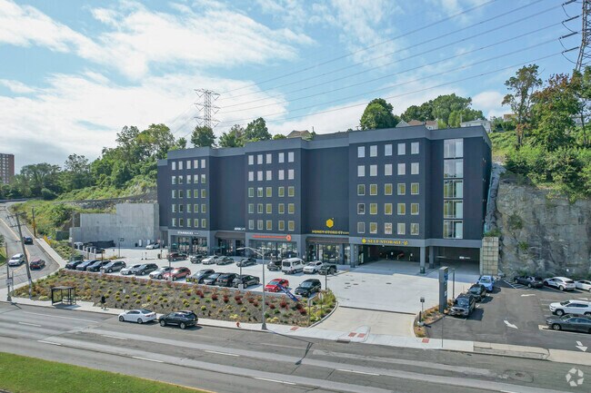
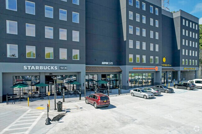
Property Record
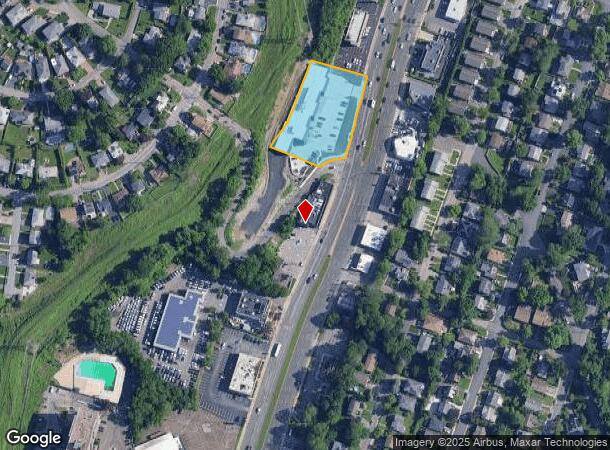
1955 Central Park Ave, Yonkers, NY 10710
NEARBY LISTINGS FOR SALE OR LEASE
Property Detail
1955 Central Park Ave
1800-004-000-04385-000-0206
Westchester
Gasolinefuelbulkstorage
New York
X
206.000
36119C0329F
1.22 AC
2025
Southwest
2024
Westchester/So Connecticut
002101
New York-Jersey City-White Plains, NY-NJ
DEMOGRAPHICS near 1955 Central Park Ave
1 Mile
3 Mile
5 Mile
2024 Total Population
20,113
161,779
490,310
2029 Population
19,852
157,977
476,427
Pop Growth 2024-2029
(1.30%)
(2.35%)
(2.83%)
Average Age
44
43
41
2024 Total Households
7,568
61,973
181,291
HH Growth 2024-2029
(1.47%)
(2.45%)
(2.94%)
Median Household Inc
$107,064
$121,699
$93,639
Avg Household Size
2.60
2.50
2.60
2024 Avg HH Vehicles
2.00
2.00
1.00
Median Home Value
$596,207
$625,037
$629,987
Median Year Built
1960
1954
1952
Nearby Places
- Restaurants
- Banks
- Shops
- Fitness
- Groceries
PUBLIC TRANSPORTATION
COMMUTER RAIL
Crestwood Station (Harlem Line - Metro-North Commuter Railroad Company (Metro-North))
DRIVE
WALK
Distance
Crestwood Station (Harlem Line - Metro-North Commuter Railroad Company (Metro-North))
4 min
1.8 mi
Tuckahoe Station (Harlem Line - Metro-North Commuter Railroad Company (Metro-North))
DRIVE
WALK
Distance
Tuckahoe Station (Harlem Line - Metro-North Commuter Railroad Company (Metro-North))
3 min
1.9 mi
AIRPORT
Westchester County
DRIVE
WALK
Distance
Westchester County
27 min
16.5 mi
LaGuardia
DRIVE
WALK
Distance
LaGuardia
31 min
18.6 mi
John F Kennedy International
DRIVE
WALK
Distance
John F Kennedy International
39 min
26.4 mi
Freight Ports
NY - Red Hook Container Terminal
DRIVE
WALK
Distance
NY - Red Hook Container Terminal
44 min
26.8 mi
SALE & LEASE HISTORY
LISTING DATE
SALE/LEASE

Dec 01, 2017
For Lease
Nearby Properties
Address
Land Use
TOTAL SIZE
Lot Size
Zoning
Address
Land Use
TOTAL SIZE
Lot Size
Zoning
18,000 SF
13.85 AC
A
Address
Land Use
TOTAL SIZE
Lot Size
Zoning
201,590 SF
4.13 AC
BA
Address
Land Use
TOTAL SIZE
Lot Size
Zoning
301,156 SF
13.94 AC
A
Address
Land Use
TOTAL SIZE
Lot Size
Zoning
70,737 SF
1.67 AC
BB
Address
Land Use
TOTAL SIZE
Lot Size
Zoning
66 AC
R-20
Address
Land Use
TOTAL SIZE
Lot Size
Zoning
101.99 AC
Address
Land Use
TOTAL SIZE
Lot Size
Zoning
23.97 AC
Address
Land Use
TOTAL SIZE
Lot Size
Zoning
Address
Land Use
TOTAL SIZE
Lot Size
Zoning
13.22 AC
CA
Address
Land Use
TOTAL SIZE
Lot Size
Zoning
29.81 AC
Address
Land Use
TOTAL SIZE
Lot Size
Zoning
68,911 SF
16.31 AC
Address
Land Use
TOTAL SIZE
Lot Size
Zoning
77.52 AC
A3
Address
Land Use
TOTAL SIZE
Lot Size
Zoning
64,165 SF
3.24 AC
B
Address
Land Use
TOTAL SIZE
Lot Size
Zoning
Address
Land Use
TOTAL SIZE
Lot Size
Zoning
Address
Land Use
TOTAL SIZE
Lot Size
Zoning
5,170 SF
9.08 AC
B
Address
Land Use
TOTAL SIZE
Lot Size
Zoning
98,910 SF
0.91 AC
VCR-0
Address
Land Use
TOTAL SIZE
Lot Size
Zoning
67,917 SF
6.79 AC
A4
Address
Land Use
TOTAL SIZE
Lot Size
Zoning
1,451 SF
6.97 AC
CA
Address
Land Use
TOTAL SIZE
Lot Size
Zoning
13.35 AC
Address
Land Use
TOTAL SIZE
Lot Size
Zoning
11.70 AC
R-30
Address
Land Use
TOTAL SIZE
Lot Size
Zoning
28.31 AC
Address
Land Use
TOTAL SIZE
Lot Size
Zoning
Address
Land Use
TOTAL SIZE
Lot Size
Zoning
58,450 SF
0.38 AC
VCR-2
Address
Land Use
TOTAL SIZE
Lot Size
Zoning
15.94 AC
Address
Land Use
TOTAL SIZE
Lot Size
Zoning
26,138 SF
0.33 AC
PUD-1
Address
Land Use
TOTAL SIZE
Lot Size
Zoning
13.56 AC
R-15
Address
Land Use
TOTAL SIZE
Lot Size
Zoning
7,855 SF
1.10 AC
C
Address
Land Use
TOTAL SIZE
Lot Size
Zoning
67,572 SF
0.46 AC
VCO-2
Address
Land Use
TOTAL SIZE
Lot Size
Zoning
50,302 SF
0.59 AC
VCR-2
The World's #1 Commercial Real Estate Marketplace
Connect with us
© 2025 CoStar Group
The information above has been obtained from sources believed reliable. While we do not doubt its accuracy we have not verified it and make no guarantee, warranty or representation about it. It is your responsibility to independently confirm its accuracy and completeness. Any projections, opinions, assumptions, or estimates used are for example only and do not represent the current or future performance of the property. The value of this transaction to you depends on tax and other factors which should be evaluated by your tax, financial, and legal advisors. You and your advisors should conduct a careful, independent investigation of the property to determine to your satisfaction the suitability of the property for your needs.