Property Record
1955 E Montgomery Xrd, Savannah, GA 31406


Save to a Folder
{{folder.Name}}
{{folder.ListingIds.length}} Properties
{{folder.ListingIds.length}} Property
Create a New Folder
Property Detail
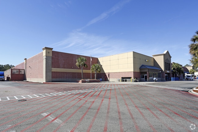
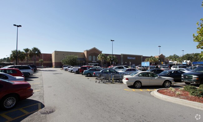
1955 E Montgomery Xrd
1042802021
TRACT 1 PT OF QUEENSBERRY TRACT SMB 36S 48 28.909 AC
Wholesaleoutletdiscountstore
Chatham
PUDBC
Georgia
B and X Area of moderate flood hazard, usually the area between the limits of the 100-year and 500-year floods.
28.91 AC
2025
Outlying Chatham County
2025
Savannah
011008
Savannah, GA
204,701 SF
NEARBY LISTINGS FOR SALE OR LEASE
DEMOGRAPHICS near 1955 E Montgomery Xrd
1 mile
3 mile
5 mile
2025 Total Population
4,174
35,268
115,337
2030 Population
4,310
36,346
119,608
Pop Growth 2025-2030
+ 3.26%
+ 3.06%
+ 3.70%
Average Age
42
41
41
2025 Total Households
1,594
14,180
47,034
HH Growth 2025-2030
+ 3.51%
+ 3.12%
+ 3.80%
Median Household Inc
$76,556
$65,993
$65,471
Avg Household Size
2.50
2.30
2.30
2025 Avg HH Vehicles
2.00
2.00
2.00
Median Home Value
$310,082
$309,760
$330,779
Median Year Built
1981
1975
1972
Nearby Places
Map Layers
Map Styles
 Street
 Aerial
Layers
 Traffic
 Biking
Places
Listings with unknown addresses are not visible on the map
- Restaurants
- Banks
- Shops
- Fitness
- Groceries
PUBLIC TRANSPORTATION
AIRPORT
Savannah/Hilton Head International
Drive
Walk
Distance
Savannah/Hilton Head International
32 min
17.7 mi
Hilton Head
Drive
Walk
Distance
Hilton Head
74 min
44.9 mi
Freight Ports
Georgia Ports - Savannah
Drive
Walk
Distance
Georgia Ports - Savannah
25 min
13.7 mi
Nearby Properties
Address
Land Use
TOTAL SIZE
Lot Size
Zoning
Address
Land Use
TOTAL SIZE
Lot Size
Zoning
559,705 SF
44.25 AC
BC
Address
Land Use
TOTAL SIZE
Lot Size
Zoning
6,245 SF
13.52 AC
PUDISB
Address
Land Use
TOTAL SIZE
Lot Size
Zoning
52,272 SF
82.59 AC
RIP
Address
Land Use
TOTAL SIZE
Lot Size
Zoning
100 SF
15.62 AC
RM25
Address
Land Use
TOTAL SIZE
Lot Size
Zoning
18,138 SF
12.80 AC
RM25
Address
Land Use
TOTAL SIZE
Lot Size
Zoning
8,480 SF
16.50 AC
PUDM25
Address
Land Use
TOTAL SIZE
Lot Size
Zoning
14,249 SF
14.92 AC
BC
Address
Land Use
TOTAL SIZE
Lot Size
Zoning
59.65 AC
RIP
Address
Land Use
TOTAL SIZE
Lot Size
Zoning
85,606 SF
16.30 AC
BC
Address
Land Use
TOTAL SIZE
Lot Size
Zoning
2,226 SF
67.62 AC
IP
Address
Land Use
TOTAL SIZE
Lot Size
Zoning
100 SF
9.78 AC
R1
Address
Land Use
TOTAL SIZE
Lot Size
Zoning
34,945 SF
18.22 AC
I-P
Address
Land Use
TOTAL SIZE
Lot Size
Zoning
15,792 SF
10.50 AC
I-P
Address
Land Use
TOTAL SIZE
Lot Size
Zoning
17.78 AC
R1
Address
Land Use
TOTAL SIZE
Lot Size
Zoning
7,500 SF
0.92 AC
RIP
Address
Land Use
TOTAL SIZE
Lot Size
Zoning
99,599 SF
13.50 AC
R1
Address
Land Use
TOTAL SIZE
Lot Size
Zoning
13,824 SF
9.50 AC
R3
Address
Land Use
TOTAL SIZE
Lot Size
Zoning
25,864 SF
8.04 AC
PBC
Address
Land Use
TOTAL SIZE
Lot Size
Zoning
5,052 SF
135 AC
I-P
Address
Land Use
TOTAL SIZE
Lot Size
Zoning
74,016 SF
27.30 AC
RIP
Address
Land Use
TOTAL SIZE
Lot Size
Zoning
116,789 SF
10.37 AC
BC1
Address
Land Use
TOTAL SIZE
Lot Size
Zoning
6,882 SF
10.96 AC
BC1
Address
Land Use
TOTAL SIZE
Lot Size
Zoning
4,576 SF
20 AC
PUDM12
Address
Land Use
TOTAL SIZE
Lot Size
Zoning
40,343 SF
16.41 AC
PUD
Address
Land Use
TOTAL SIZE
Lot Size
Zoning
94,080 SF
12.70 AC
PUDM
Address
Land Use
TOTAL SIZE
Lot Size
Zoning
86,660 SF
7.71 AC
R6
Address
Land Use
TOTAL SIZE
Lot Size
Zoning
3,975 SF
11.66 AC
BC
Address
Land Use
TOTAL SIZE
Lot Size
Zoning
97,902 SF
32.30 AC
R1
Address
Land Use
TOTAL SIZE
Lot Size
Zoning
54,550 SF
1.21 AC
The World's #1 Commercial Real Estate Marketplace
Connect with us
© 2026 CoStar Group
The information above has been obtained from sources believed reliable. While we do not doubt its accuracy we have not verified it and make no guarantee, warranty or representation about it. It is your responsibility to independently confirm its accuracy and completeness. Any projections, opinions, assumptions, or estimates used are for example only and do not represent the current or future performance of the property. The value of this transaction to you depends on tax and other factors which should be evaluated by your tax, financial, and legal advisors. You and your advisors should conduct a careful, independent investigation of the property to determine to your satisfaction the suitability of the property for your needs.