Property Record
1955 Sigman Rd Nw, Conyers, GA 30012
NEARBY LISTINGS FOR SALE OR LEASE
Property Detail
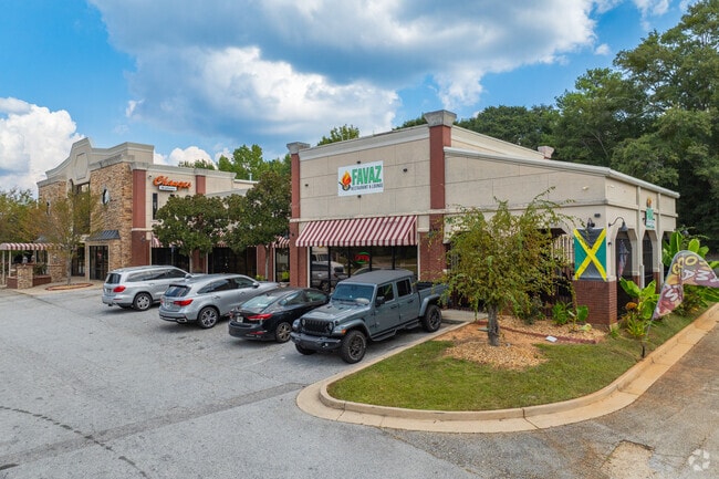
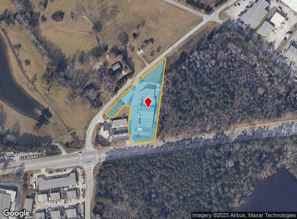
1955 Sigman Rd Nw
Atlanta-Sandy Springs-Roswell, GA
Commercial
022-0-01-025B
E/SIDE FARMER RD & (1955)
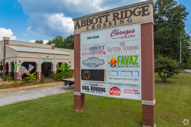
Stripcommercialcenter
Rockdale
X
Georgia
13247C0091D
t2
2024
2.43 AC
2024
Lithonia/Conyers
060310
Atlanta
28,700 SF
DEMOGRAPHICS near 1955 Sigman Rd Nw
1 Mile
3 Mile
5 Mile
2024 Total Population
606
31,104
74,354
2029 Population
635
32,076
76,374
Pop Growth 2024-2029
+ 4.79%
+ 3.13%
+ 2.72%
Average Age
37
38
38
2024 Total Households
203
11,229
27,221
HH Growth 2024-2029
+ 4.93%
+ 3.04%
+ 2.58%
Median Household Inc
$69,999
$63,405
$60,606
Avg Household Size
2.60
2.70
2.60
2024 Avg HH Vehicles
2.00
2.00
2.00
Median Home Value
$174,509
$193,710
$203,247
Median Year Built
2001
1984
1990
Nearby Places
Map Layers
Map Styles
 Street
 Aerial
- Restaurants
- Banks
- Shops
- Fitness
- Groceries
PUBLIC TRANSPORTATION
AIRPORT
Hartsfield - Jackson Atlanta International
DRIVE
WALK
Distance
Hartsfield - Jackson Atlanta International
36 min
25.7 mi
Freight Ports
Georgia Ports - Savannah
DRIVE
WALK
Distance
Georgia Ports - Savannah
281 min
243.5 mi
SALE & LEASE HISTORY
LISTING DATE
SALE/LEASE

May 22, 2017
For Sale
Nearby Properties
Address
Land Use
TOTAL SIZE
Lot Size
Zoning
Address
Land Use
TOTAL SIZE
Lot Size
Zoning
224,892 SF
17.81 AC
RM100
Address
Land Use
TOTAL SIZE
Lot Size
Zoning
405,288 SF
28.89 AC
C1
Address
Land Use
TOTAL SIZE
Lot Size
Zoning
2,782 SF
29.51 AC
R3/C
Address
Land Use
TOTAL SIZE
Lot Size
Zoning
194,186 SF
18.48 AC
RM100
Address
Land Use
TOTAL SIZE
Lot Size
Zoning
290,616 SF
23.84 AC
M-1
Address
Land Use
TOTAL SIZE
Lot Size
Zoning
458,448 SF
12.98 AC
OI
Address
Land Use
TOTAL SIZE
Lot Size
Zoning
28,024 SF
11.24 AC
R1
Address
Land Use
TOTAL SIZE
Lot Size
Zoning
140,058 SF
8.46 AC
C1
Address
Land Use
TOTAL SIZE
Lot Size
Zoning
20,964 SF
25.29 AC
R3/C
Address
Land Use
TOTAL SIZE
Lot Size
Zoning
263,339 SF
24.24 AC
C1
Address
Land Use
TOTAL SIZE
Lot Size
Zoning
165,171 SF
49.79 AC
BG/ID
Address
Land Use
TOTAL SIZE
Lot Size
Zoning
417,378 SF
31.95 AC
M1
Address
Land Use
TOTAL SIZE
Lot Size
Zoning
173,427 SF
15.18 AC
X
Address
Land Use
TOTAL SIZE
Lot Size
Zoning
273,000 SF
15.41 AC
M1
Address
Land Use
TOTAL SIZE
Lot Size
Zoning
3,888 SF
21.05 AC
RM/C
Address
Land Use
TOTAL SIZE
Lot Size
Zoning
472,620 SF
55.20 AC
RS10
Address
Land Use
TOTAL SIZE
Lot Size
Zoning
152,302 SF
17.91 AC
X
Address
Land Use
TOTAL SIZE
Lot Size
Zoning
76,140 SF
22.20 AC
RM
Address
Land Use
TOTAL SIZE
Lot Size
Zoning
124,591 SF
13.89 AC
C2
Address
Land Use
TOTAL SIZE
Lot Size
Zoning
485,258 SF
23.61 AC
M
Address
Land Use
TOTAL SIZE
Lot Size
Zoning
159,014 SF
3.88 AC
RM
Address
Land Use
TOTAL SIZE
Lot Size
Zoning
60,470 SF
5.11 AC
C2
Address
Land Use
TOTAL SIZE
Lot Size
Zoning
196,560 SF
12.06 AC
MI
Address
Land Use
TOTAL SIZE
Lot Size
Zoning
38.94 AC
M
Address
Land Use
TOTAL SIZE
Lot Size
Zoning
14,575 SF
14.55 AC
OI
Address
Land Use
TOTAL SIZE
Lot Size
Zoning
1,968 SF
26.91 AC
M2
Address
Land Use
TOTAL SIZE
Lot Size
Zoning
110,813 SF
53.11 AC
RM/C
Address
Land Use
TOTAL SIZE
Lot Size
Zoning
16,724 SF
8.33 AC
C2
Address
Land Use
TOTAL SIZE
Lot Size
Zoning
105,600 SF
8.75 AC
M1
Address
Land Use
TOTAL SIZE
Lot Size
Zoning
713,040 SF
67.04 AC
M1
The World's #1 Commercial Real Estate Marketplace
Connect with us
© 2025 CoStar Group
The information above has been obtained from sources believed reliable. While we do not doubt its accuracy we have not verified it and make no guarantee, warranty or representation about it. It is your responsibility to independently confirm its accuracy and completeness. Any projections, opinions, assumptions, or estimates used are for example only and do not represent the current or future performance of the property. The value of this transaction to you depends on tax and other factors which should be evaluated by your tax, financial, and legal advisors. You and your advisors should conduct a careful, independent investigation of the property to determine to your satisfaction the suitability of the property for your needs.