Property Record
1955 W Cornwallis Rd, Durham, NC 27705
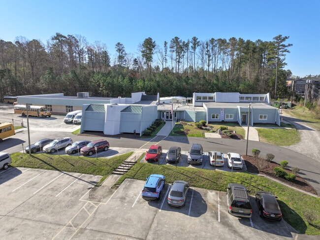

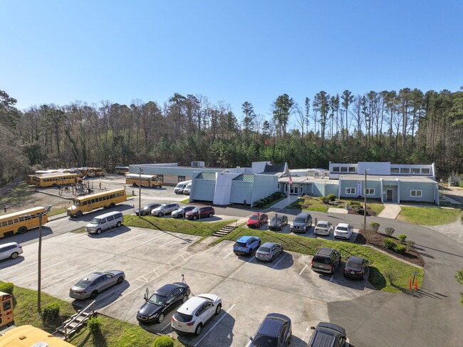

This Property Is For Sale
Property Detail
1955 W Cornwallis Rd
121305
PROP-DURHAM COMMUNITY CHA RTER SCHOOL DBA/CARTER C PL:000185-000139
Publicschool
Durham
RS-10
North Carolina
B and X Area of moderate flood hazard, usually the area between the limits of the 100-year and 500-year floods.
4.90 AC
0
South Durham
2025
Raleigh/Durham
002030
Durham-Chapel Hill, NC
22,158 SF
NEARBY LISTINGS FOR SALE OR LEASE
DEMOGRAPHICS near 1955 W Cornwallis Rd
1 mile
3 mile
5 mile
2025 Total Population
5,577
72,731
189,612
2030 Population
5,994
77,058
200,687
Pop Growth 2025-2030
+ 7.48%
+ 5.95%
+ 5.84%
Average Age
42
37
38
2025 Total Households
2,531
31,943
81,409
HH Growth 2025-2030
+ 7.59%
+ 6.49%
+ 6.22%
Median Household Inc
$110,050
$69,609
$76,883
Avg Household Size
2.10
2.10
2.20
2025 Avg HH Vehicles
1.00
1.00
2.00
Median Home Value
$665,125
$516,282
$462,515
Median Year Built
1990
1988
1988
Nearby Places
Map Layers
Map Styles
 Street
 Aerial
Transit
 Traffic
 Biking
Places
Listings with unknown addresses are not visible on the map
- Restaurants
- Banks
- Shops
- Fitness
- Groceries
PUBLIC TRANSPORTATION
COMMUTER RAIL
Durham Amtrak Station (Carolinian - Amtrak, Piedmont - Amtrak)
Drive
Walk
Distance
Durham Amtrak Station (Carolinian - Amtrak, Piedmont - Amtrak)
10 min
4.1 mi
AIRPORT
Raleigh-Durham International
Drive
Walk
Distance
Raleigh-Durham International
27 min
15.4 mi
Freight Ports
Virginia Port Authority - Richmond
Drive
Walk
Distance
Virginia Port Authority - Richmond
172 min
151.2 mi
Nearby Properties
Address
Land Use
TOTAL SIZE
Lot Size
Zoning
Address
Land Use
TOTAL SIZE
Lot Size
Zoning
8,478 SF
676.09 AC
UC
Address
Land Use
TOTAL SIZE
Lot Size
Zoning
26,512 SF
6.40 AC
CD-C
Address
Land Use
TOTAL SIZE
Lot Size
Zoning
216,220 SF
3.70 AC
CSD-C
Address
Land Use
TOTAL SIZE
Lot Size
Zoning
85,220 SF
20.34 AC
CSD-S1
Address
Land Use
TOTAL SIZE
Lot Size
Zoning
24,741 SF
5.67 AC
CD-S1
Address
Land Use
TOTAL SIZE
Lot Size
Zoning
63,921 SF
3.76 AC
DD-C
Address
Land Use
TOTAL SIZE
Lot Size
Zoning
63,464 SF
23.42 AC
PDR 0.000
Address
Land Use
TOTAL SIZE
Lot Size
Zoning
416,469 SF
3.85 AC
MU(D)
Address
Land Use
TOTAL SIZE
Lot Size
Zoning
3.20 AC
CD-S1
Address
Land Use
TOTAL SIZE
Lot Size
Zoning
435.74 AC
UC(D)
Address
Land Use
TOTAL SIZE
Lot Size
Zoning
812,903 SF
9.31 AC
UC
Address
Land Use
TOTAL SIZE
Lot Size
Zoning
90,416 SF
3.87 AC
CD-S1
Address
Land Use
TOTAL SIZE
Lot Size
Zoning
26,448 SF
22.07 AC
CSD-S1
Address
Land Use
TOTAL SIZE
Lot Size
Zoning
478,037 SF
4.51 AC
DD-C
Address
Land Use
TOTAL SIZE
Lot Size
Zoning
132,520 SF
15.94 AC
RU-M(D)
Address
Land Use
TOTAL SIZE
Lot Size
Zoning
12,236 SF
43.44 AC
RU-M
Address
Land Use
TOTAL SIZE
Lot Size
Zoning
298,580 SF
6.73 AC
MU(D)
Address
Land Use
TOTAL SIZE
Lot Size
Zoning
125,552 SF
3.23 AC
UC(D)
Address
Land Use
TOTAL SIZE
Lot Size
Zoning
218,882 SF
3.10 AC
DD-S1
Address
Land Use
TOTAL SIZE
Lot Size
Zoning
441,868 SF
6.11 AC
MU(D)
Address
Land Use
TOTAL SIZE
Lot Size
Zoning
24,183 SF
60.28 AC
PDR 9.280
Address
Land Use
TOTAL SIZE
Lot Size
Zoning
234,754 SF
4.85 AC
UC
Address
Land Use
TOTAL SIZE
Lot Size
Zoning
368,569 SF
2.77 AC
Address
Land Use
TOTAL SIZE
Lot Size
Zoning
358,462 SF
1.48 AC
DD-C
Address
Land Use
TOTAL SIZE
Lot Size
Zoning
903.08 AC
RR,RS-20,U
Address
Land Use
TOTAL SIZE
Lot Size
Zoning
10,680 SF
33.33 AC
PDR 4.110
Address
Land Use
TOTAL SIZE
Lot Size
Zoning
296,580 SF
2.53 AC
MU(D)
Address
Land Use
TOTAL SIZE
Lot Size
Zoning
22,038 SF
24.63 AC
CSD-S2
Address
Land Use
TOTAL SIZE
Lot Size
Zoning
167,530 SF
1.46 AC
DD-S1
Address
Land Use
TOTAL SIZE
Lot Size
Zoning
12,585 SF
57.79 AC
PDR 6.420
The World's #1 Commercial Real Estate Marketplace
Connect with us
© 2026 CoStar Group
The information above has been obtained from sources believed reliable. While we do not doubt its accuracy we have not verified it and make no guarantee, warranty or representation about it. It is your responsibility to independently confirm its accuracy and completeness. Any projections, opinions, assumptions, or estimates used are for example only and do not represent the current or future performance of the property. The value of this transaction to you depends on tax and other factors which should be evaluated by your tax, financial, and legal advisors. You and your advisors should conduct a careful, independent investigation of the property to determine to your satisfaction the suitability of the property for your needs.