Property Record
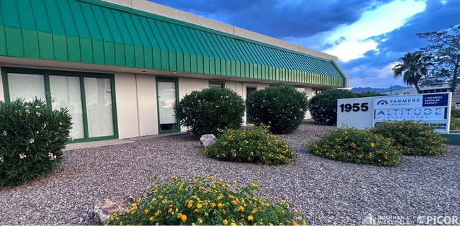
1955 W Grant Rd, Tucson, AZ 85745


Current Lease Availabilities
NEARBY LISTINGS FOR SALE OR LEASE
Property Detail
1955 W Grant Rd
115-20-2720
West Grant Centre
Warehouse
PTN E301.10 W774 N488.7 NW4 NW4 2.62 AC SEC 03-14-13
X
Pima
04019C2260L
Arizona
2025
2.62 AC
2026
NW Tucson/Oro Valley
001200
Tucson
40,151 SF
Tucson, AZ
DEMOGRAPHICS near 1955 W Grant Rd
1 mile
3 mile
5 mile
2024 Total Population
10,042
79,089
195,564
2029 Population
10,567
82,350
202,745
Pop Growth 2024-2029
+ 5.23%
+ 4.12%
+ 3.67%
Average Age
37
38
38
2024 Total Households
4,110
35,366
86,578
HH Growth 2024-2029
+ 5.28%
+ 4.20%
+ 3.77%
Median Household Inc
$59,781
$39,409
$43,254
Avg Household Size
2.40
2.20
2.10
2024 Avg HH Vehicles
2.00
1.00
2.00
Median Home Value
$232,586
$183,249
$233,077
Median Year Built
1992
1980
1978
Nearby Places
Map Layers
Map Styles
 Street
 Aerial
Transit
 Traffic
 Biking
Places
Listings with unknown addresses are not visible on the map
- Restaurants
- Banks
- Shops
- Fitness
- Groceries
PUBLIC TRANSPORTATION
COMMUTER RAIL
Drive
Walk
Distance
8 min
4.3 mi
AIRPORT
Tucson International
Drive
Walk
Distance
Tucson International
20 min
11.8 mi
Nearby Properties
Address
Land Use
TOTAL SIZE
Lot Size
Zoning
Address
Land Use
TOTAL SIZE
Lot Size
Zoning
134,710 SF
9.59 AC
I1
Address
Land Use
TOTAL SIZE
Lot Size
Zoning
106,852 SF
19.50 AC
I1
Address
Land Use
TOTAL SIZE
Lot Size
Zoning
813,186 SF
3.65 AC
OCR2
Address
Land Use
TOTAL SIZE
Lot Size
Zoning
866,763 SF
17.17 AC
O3
Address
Land Use
TOTAL SIZE
Lot Size
Zoning
239,060 SF
7.85 AC
Address
Land Use
TOTAL SIZE
Lot Size
Zoning
495,871 SF
3.56 AC
Address
Land Use
TOTAL SIZE
Lot Size
Zoning
21,126 SF
1.10 AC
O3
Address
Land Use
TOTAL SIZE
Lot Size
Zoning
652,898 SF
233.08 AC
RX2
Address
Land Use
TOTAL SIZE
Lot Size
Zoning
39,508 SF
7.29 AC
MU
Address
Land Use
TOTAL SIZE
Lot Size
Zoning
300,034 SF
2.45 AC
C3
Address
Land Use
TOTAL SIZE
Lot Size
Zoning
418,519 SF
2.36 AC
OCR2
Address
Land Use
TOTAL SIZE
Lot Size
Zoning
298,003 SF
0.73 AC
Address
Land Use
TOTAL SIZE
Lot Size
Zoning
222,699 SF
2.22 AC
Address
Land Use
TOTAL SIZE
Lot Size
Zoning
213,066 SF
0.91 AC
OCR2
Address
Land Use
TOTAL SIZE
Lot Size
Zoning
251,043 SF
14.96 AC
Address
Land Use
TOTAL SIZE
Lot Size
Zoning
119,165 SF
21.85 AC
I1
Address
Land Use
TOTAL SIZE
Lot Size
Zoning
177,018 SF
16.78 AC
C2
Address
Land Use
TOTAL SIZE
Lot Size
Zoning
135,572 SF
0.36 AC
Address
Land Use
TOTAL SIZE
Lot Size
Zoning
36,100 SF
2.42 AC
I1
Address
Land Use
TOTAL SIZE
Lot Size
Zoning
246,038 SF
0.95 AC
Address
Land Use
TOTAL SIZE
Lot Size
Zoning
22,174 SF
89.89 AC
SR
Address
Land Use
TOTAL SIZE
Lot Size
Zoning
312,586 SF
28.73 AC
Address
Land Use
TOTAL SIZE
Lot Size
Zoning
261,229 SF
1.75 AC
Address
Land Use
TOTAL SIZE
Lot Size
Zoning
24,100 SF
4.96 AC
MU
Address
Land Use
TOTAL SIZE
Lot Size
Zoning
21,000 SF
9.34 AC
Address
Land Use
TOTAL SIZE
Lot Size
Zoning
248,388 SF
20.45 AC
O3
Address
Land Use
TOTAL SIZE
Lot Size
Zoning
209,967 SF
14.19 AC
Address
Land Use
TOTAL SIZE
Lot Size
Zoning
291,038 SF
16.42 AC
C1
Address
Land Use
TOTAL SIZE
Lot Size
Zoning
214,907 SF
12.03 AC
C1
Address
Land Use
TOTAL SIZE
Lot Size
Zoning
227,880 SF
0.21 AC
OCR2
The World's #1 Commercial Real Estate Marketplace
Connect with us
© 2026 CoStar Group
The information above has been obtained from sources believed reliable. While we do not doubt its accuracy we have not verified it and make no guarantee, warranty or representation about it. It is your responsibility to independently confirm its accuracy and completeness. Any projections, opinions, assumptions, or estimates used are for example only and do not represent the current or future performance of the property. The value of this transaction to you depends on tax and other factors which should be evaluated by your tax, financial, and legal advisors. You and your advisors should conduct a careful, independent investigation of the property to determine to your satisfaction the suitability of the property for your needs.