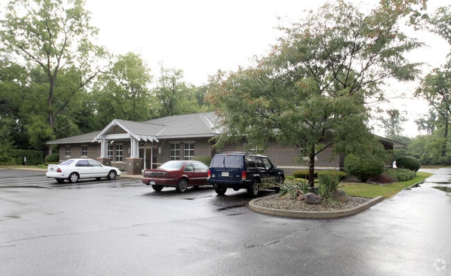
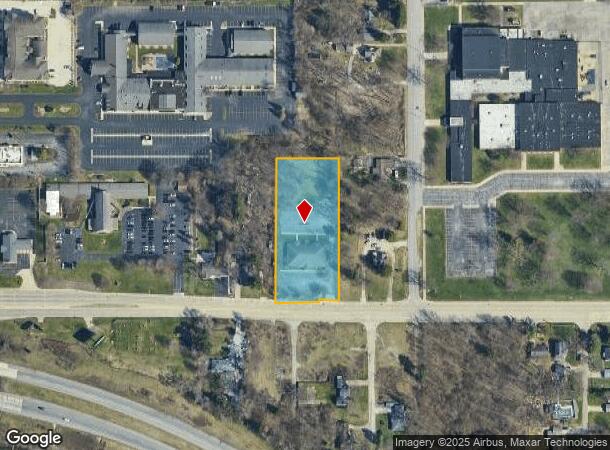
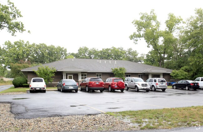
Property Record
19567 Cleveland Rd, South Bend, IN 46637
NEARBY LISTINGS FOR SALE OR LEASE
Property Detail
19567 Cleveland Rd
71-03-24-376-034.000-003
186.7 FRONT CLEVELAND RD S SE SW 24-38-2E 1.917 ACRES EX .053 AC STRIP N OF CLEVELAND RD SOLD FOR R/W SOLD 10-15-93
Medicalbuilding
St Joseph
X
Indiana
18141C0201D
1.92 AC
2023
Outlying St Joseph County
2024
South Bend/Mishawaka
011303
South Bend-Mishawaka, IN-MI
6,684 SF
DEMOGRAPHICS near 19567 Cleveland Rd
1 Mile
3 Mile
5 Mile
2024 Total Population
4,779
63,171
154,093
2029 Population
4,837
63,356
154,397
Pop Growth 2024-2029
+ 1.21%
+ 0.29%
+ 0.20%
Average Age
41
37
38
2024 Total Households
2,078
23,252
60,019
HH Growth 2024-2029
+ 1.30%
+ 0.34%
+ 0.18%
Median Household Inc
$57,884
$62,866
$54,323
Avg Household Size
2.20
2.30
2.30
2024 Avg HH Vehicles
2.00
2.00
2.00
Median Home Value
$159,596
$168,448
$154,053
Median Year Built
1963
1971
1965
Nearby Places
Map Layers
Map Styles
 Street
 Aerial
- Restaurants
- Banks
- Shops
- Fitness
- Groceries
PUBLIC TRANSPORTATION
COMMUTER RAIL
South Bend Airport Station (South Shore Line - Northern Indiana Commuter Transportation District (South Shore Line))
DRIVE
WALK
Distance
South Bend Airport Station (South Shore Line - Northern Indiana Commuter Transportation District (South Shore Line))
12 min
5.2 mi
South Bend Amtrak Station (Capitol Limited - Amtrak, Lake Shore Limited - Amtrak)
DRIVE
WALK
Distance
South Bend Amtrak Station (Capitol Limited - Amtrak, Lake Shore Limited - Amtrak)
12 min
5.3 mi
AIRPORT
South Bend International
DRIVE
WALK
Distance
South Bend International
23 min
8.2 mi
Freight Ports
Port Milwaukee
DRIVE
WALK
Distance
Port Milwaukee
216 min
179.2 mi
Nearby Properties
Address
Land Use
TOTAL SIZE
Lot Size
Zoning
Address
Land Use
TOTAL SIZE
Lot Size
Zoning
3,879,729 SF
436.76 AC
Address
Land Use
TOTAL SIZE
Lot Size
Zoning
685,709 SF
44 SF
Address
Land Use
TOTAL SIZE
Lot Size
Zoning
808,463 SF
30.51 AC
Address
Land Use
TOTAL SIZE
Lot Size
Zoning
24,392 SF
48.07 AC
Address
Land Use
TOTAL SIZE
Lot Size
Zoning
966,201 SF
0.01 AC
Address
Land Use
TOTAL SIZE
Lot Size
Zoning
294,502 SF
87 SF
Address
Land Use
TOTAL SIZE
Lot Size
Zoning
369,116 SF
19.80 AC
Address
Land Use
TOTAL SIZE
Lot Size
Zoning
168,997 SF
9.62 AC
Address
Land Use
TOTAL SIZE
Lot Size
Zoning
599,502 SF
39.10 AC
Address
Land Use
TOTAL SIZE
Lot Size
Zoning
394,459 SF
44 SF
Address
Land Use
TOTAL SIZE
Lot Size
Zoning
538,338 SF
0.01 AC
Address
Land Use
TOTAL SIZE
Lot Size
Zoning
160,546 SF
Address
Land Use
TOTAL SIZE
Lot Size
Zoning
319,715 SF
2.57 AC
Address
Land Use
TOTAL SIZE
Lot Size
Zoning
151,377 SF
0.01 AC
Address
Land Use
TOTAL SIZE
Lot Size
Zoning
206,651 SF
1.68 AC
Address
Land Use
TOTAL SIZE
Lot Size
Zoning
393,123 SF
2.91 AC
Address
Land Use
TOTAL SIZE
Lot Size
Zoning
207,846 SF
2.33 AC
Address
Land Use
TOTAL SIZE
Lot Size
Zoning
799,664 SF
0.01 AC
Address
Land Use
TOTAL SIZE
Lot Size
Zoning
148,524 SF
1.66 AC
Address
Land Use
TOTAL SIZE
Lot Size
Zoning
25,756 SF
337.40 AC
Address
Land Use
TOTAL SIZE
Lot Size
Zoning
356,520 SF
28.07 AC
Address
Land Use
TOTAL SIZE
Lot Size
Zoning
174,997 SF
0.70 AC
Address
Land Use
TOTAL SIZE
Lot Size
Zoning
128,298 SF
0.84 AC
Address
Land Use
TOTAL SIZE
Lot Size
Zoning
187,073 SF
11.52 AC
Address
Land Use
TOTAL SIZE
Lot Size
Zoning
73,254 SF
96.72 AC
Address
Land Use
TOTAL SIZE
Lot Size
Zoning
167,261 SF
1.58 AC
Address
Land Use
TOTAL SIZE
Lot Size
Zoning
747,842 SF
30.05 AC
Address
Land Use
TOTAL SIZE
Lot Size
Zoning
142,065 SF
44 SF
Address
Land Use
TOTAL SIZE
Lot Size
Zoning
151,852 SF
0.86 AC
Address
Land Use
TOTAL SIZE
Lot Size
Zoning
140,994 SF
13.58 AC
The World's #1 Commercial Real Estate Marketplace
Connect with us
© 2025 CoStar Group
The information above has been obtained from sources believed reliable. While we do not doubt its accuracy we have not verified it and make no guarantee, warranty or representation about it. It is your responsibility to independently confirm its accuracy and completeness. Any projections, opinions, assumptions, or estimates used are for example only and do not represent the current or future performance of the property. The value of this transaction to you depends on tax and other factors which should be evaluated by your tax, financial, and legal advisors. You and your advisors should conduct a careful, independent investigation of the property to determine to your satisfaction the suitability of the property for your needs.