Property Record
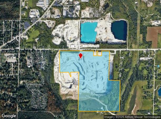
19567 W Good Hope Rd, Lannon, WI 53046
NEARBY LISTINGS FOR SALE OR LEASE
Property Detail
19567 W Good Hope Rd
Milwaukee-Waukesha-West Allis, WI
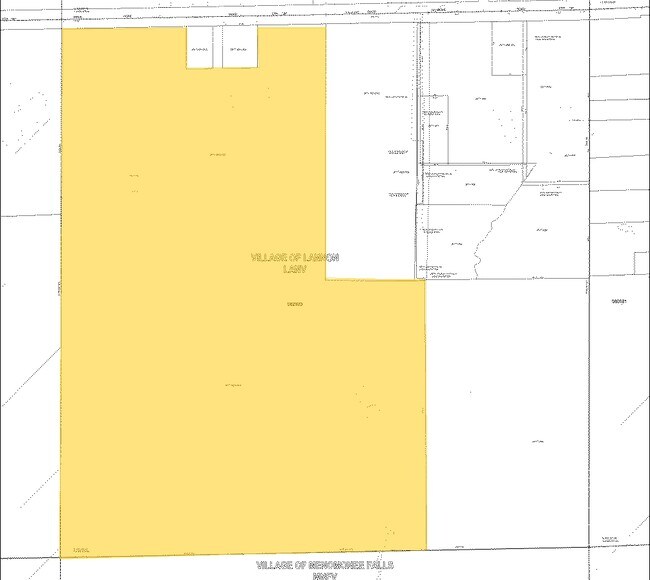
Certified Surv Map 10349
LANV-0077-993-002
PT CSM #10349 VOL 98/113 REC AS DOC #3458892 AS DESC BELOW; W1/2 NE1/4 SEC 20 T8N R20E & PT SE1/4 NE1/4 SEC 10 T8N R20E; COM E1/4 CRNR; N8856W 801.63 FT TO BGN; N8856W 499.37 FT; N0220E 1325.00 FT; S8923E 490.00 FT; S0156W 1329.10 FT TO BGN :: ALSO P
Industrialgeneral
Waukesha
AE
Wisconsin
55133C0094H
8
2024
112.20 AC
2024
NE/Menomonee Falls
200300
Milwaukee/Madison
DEMOGRAPHICS near 19567 W Good Hope Rd
1 Mile
3 Mile
5 Mile
2024 Total Population
1,641
27,229
76,460
2029 Population
1,637
27,557
77,409
Pop Growth 2024-2029
(0.24%)
+ 1.20%
+ 1.24%
Average Age
42
44
43
2024 Total Households
655
11,291
30,752
HH Growth 2024-2029
(0.31%)
+ 1.15%
+ 1.10%
Median Household Inc
$79,973
$91,611
$99,875
Avg Household Size
2.50
2.40
2.40
2024 Avg HH Vehicles
2.00
2.00
2.00
Median Home Value
$299,098
$306,810
$329,454
Median Year Built
1993
1978
1981
Nearby Places
Map Layers
Map Styles
 Street
 Aerial
- Restaurants
- Banks
- Shops
- Fitness
- Groceries
PUBLIC TRANSPORTATION
AIRPORT
General Mitchell International
DRIVE
WALK
Distance
General Mitchell International
41 min
25.6 mi
Freight Ports
Port Milwaukee
DRIVE
WALK
Distance
Port Milwaukee
35 min
21.8 mi
Nearby Properties
Address
Land Use
TOTAL SIZE
Lot Size
Zoning
Address
Land Use
TOTAL SIZE
Lot Size
Zoning
145,836 SF
11 AC
Address
Land Use
TOTAL SIZE
Lot Size
Zoning
294,486 SF
12.78 AC
Address
Land Use
TOTAL SIZE
Lot Size
Zoning
864,365 SF
50.22 AC
Address
Land Use
TOTAL SIZE
Lot Size
Zoning
74.81 AC
Address
Land Use
TOTAL SIZE
Lot Size
Zoning
145,844 SF
27.98 AC
Address
Land Use
TOTAL SIZE
Lot Size
Zoning
358,699 SF
24.97 AC
Address
Land Use
TOTAL SIZE
Lot Size
Zoning
192,963 SF
16.43 AC
Address
Land Use
TOTAL SIZE
Lot Size
Zoning
24.03 AC
Address
Land Use
TOTAL SIZE
Lot Size
Zoning
204,175 SF
2.48 AC
Address
Land Use
TOTAL SIZE
Lot Size
Zoning
104,642 SF
7.06 AC
Address
Land Use
TOTAL SIZE
Lot Size
Zoning
302,895 SF
7.90 AC
Address
Land Use
TOTAL SIZE
Lot Size
Zoning
245,615 SF
15.88 AC
Address
Land Use
TOTAL SIZE
Lot Size
Zoning
12.64 AC
Address
Land Use
TOTAL SIZE
Lot Size
Zoning
14.12 AC
Address
Land Use
TOTAL SIZE
Lot Size
Zoning
34.36 AC
Address
Land Use
TOTAL SIZE
Lot Size
Zoning
90,077 SF
0.95 AC
Address
Land Use
TOTAL SIZE
Lot Size
Zoning
Address
Land Use
TOTAL SIZE
Lot Size
Zoning
107,772 SF
4.73 AC
Address
Land Use
TOTAL SIZE
Lot Size
Zoning
85,193 SF
3.71 AC
Address
Land Use
TOTAL SIZE
Lot Size
Zoning
18.03 AC
Address
Land Use
TOTAL SIZE
Lot Size
Zoning
95,367 SF
5.42 AC
Address
Land Use
TOTAL SIZE
Lot Size
Zoning
31,144 SF
26.95 AC
Address
Land Use
TOTAL SIZE
Lot Size
Zoning
94,963 SF
13.30 AC
Address
Land Use
TOTAL SIZE
Lot Size
Zoning
10.17 AC
Address
Land Use
TOTAL SIZE
Lot Size
Zoning
Address
Land Use
TOTAL SIZE
Lot Size
Zoning
67,777 SF
20.22 AC
Address
Land Use
TOTAL SIZE
Lot Size
Zoning
110,307 SF
3.69 AC
Address
Land Use
TOTAL SIZE
Lot Size
Zoning
Address
Land Use
TOTAL SIZE
Lot Size
Zoning
27,148 SF
5.92 AC
Address
Land Use
TOTAL SIZE
Lot Size
Zoning
61,698 SF
3.05 AC
The World's #1 Commercial Real Estate Marketplace
Connect with us
© 2025 CoStar Group
The information above has been obtained from sources believed reliable. While we do not doubt its accuracy we have not verified it and make no guarantee, warranty or representation about it. It is your responsibility to independently confirm its accuracy and completeness. Any projections, opinions, assumptions, or estimates used are for example only and do not represent the current or future performance of the property. The value of this transaction to you depends on tax and other factors which should be evaluated by your tax, financial, and legal advisors. You and your advisors should conduct a careful, independent investigation of the property to determine to your satisfaction the suitability of the property for your needs.