Property Record
1957 S Westmoreland Rd, Glenn Heights, TX 75154
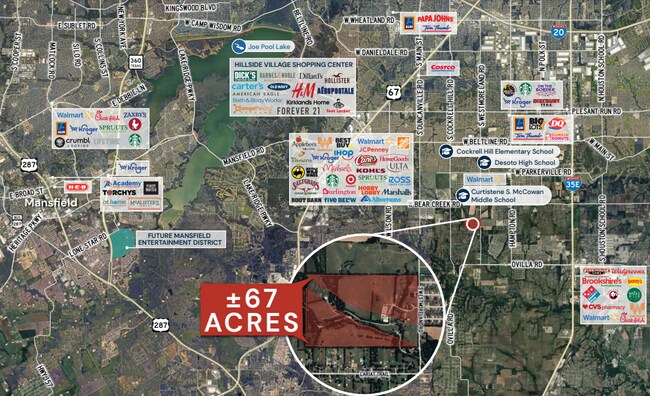

This Property Is For Sale
NEARBY LISTINGS FOR SALE OR LEASE
Property Detail
1957 S Westmoreland Rd
Dallas/Ft Worth
Newton C Laughlin
Dallas-Fort Worth-Arlington, TX
Dallas
65076442510020100
Texas
Privatepreserveopenspacevacantlandforestlandconservation
0.92 AC
X
Southwest Dallas
48139C0065G
DEMOGRAPHICS near 1957 S Westmoreland Rd
1 Mile
3 Mile
5 Mile
2024 Total Population
3,042
52,401
136,462
2029 Population
3,807
61,969
160,024
Pop Growth 2024-2029
+ 25.15%
+ 18.26%
+ 17.27%
Average Age
39
38
38
2024 Total Households
1,058
17,088
45,776
HH Growth 2024-2029
+ 25.90%
+ 18.51%
+ 16.99%
Median Household Inc
$95,131
$95,911
$89,970
Avg Household Size
2.90
3.00
2.90
2024 Avg HH Vehicles
2.00
2.00
2.00
Median Home Value
$262,224
$257,580
$258,645
Median Year Built
2003
2003
1999
Nearby Places
Map Layers
Map Styles
 Street
 Aerial
- Restaurants
- Banks
- Shops
- Fitness
- Groceries
PUBLIC TRANSPORTATION
AIRPORT
Dallas Love Field
DRIVE
WALK
Distance
Dallas Love Field
37 min
25.4 mi
Dallas-Fort Worth International
DRIVE
WALK
Distance
Dallas-Fort Worth International
48 min
33.0 mi
Freight Ports
Port of Shreveport
DRIVE
WALK
Distance
Port of Shreveport
224 min
206.5 mi
Nearby Properties
Address
Land Use
TOTAL SIZE
Lot Size
Zoning
Address
Land Use
TOTAL SIZE
Lot Size
Zoning
227,423 SF
13.86 AC
Z236
Address
Land Use
TOTAL SIZE
Lot Size
Zoning
281,669 SF
16.02 AC
Z312
Address
Land Use
TOTAL SIZE
Lot Size
Zoning
330,541 SF
14.85 AC
Address
Land Use
TOTAL SIZE
Lot Size
Zoning
253,794 SF
10.23 AC
Z201
Address
Land Use
TOTAL SIZE
Lot Size
Zoning
140,590 SF
4.90 AC
Z236
Address
Land Use
TOTAL SIZE
Lot Size
Zoning
190,592 SF
101.54 AC
Z370
Address
Land Use
TOTAL SIZE
Lot Size
Zoning
55,213 SF
11.83 AC
Z197
Address
Land Use
TOTAL SIZE
Lot Size
Zoning
383 SF
56.48 AC
Z07
Address
Land Use
TOTAL SIZE
Lot Size
Zoning
109,500 SF
12.13 AC
Z370
Address
Land Use
TOTAL SIZE
Lot Size
Zoning
117,564 SF
25.59 AC
Address
Land Use
TOTAL SIZE
Lot Size
Zoning
209,051 SF
37.20 AC
Z312
Address
Land Use
TOTAL SIZE
Lot Size
Zoning
49,620 SF
10.04 AC
Z373
Address
Land Use
TOTAL SIZE
Lot Size
Zoning
116,318 SF
14.92 AC
Address
Land Use
TOTAL SIZE
Lot Size
Zoning
148 SF
20.14 AC
Z159
Address
Land Use
TOTAL SIZE
Lot Size
Zoning
119 SF
31.32 AC
Z155
Address
Land Use
TOTAL SIZE
Lot Size
Zoning
50,428 SF
14.25 AC
Z313
Address
Land Use
TOTAL SIZE
Lot Size
Zoning
76,454 SF
15.37 AC
Z97
Address
Land Use
TOTAL SIZE
Lot Size
Zoning
14,392 SF
2.01 AC
Z236
Address
Land Use
TOTAL SIZE
Lot Size
Zoning
85,050 SF
4.98 AC
Z370
Address
Land Use
TOTAL SIZE
Lot Size
Zoning
151 SF
10.89 AC
Z159
Address
Land Use
TOTAL SIZE
Lot Size
Zoning
0.01 AC
Z362
Address
Land Use
TOTAL SIZE
Lot Size
Zoning
79,612 SF
2.67 AC
Address
Land Use
TOTAL SIZE
Lot Size
Zoning
70,000 SF
6.05 AC
Z236
Address
Land Use
TOTAL SIZE
Lot Size
Zoning
41,117 SF
5.34 AC
Z51
Address
Land Use
TOTAL SIZE
Lot Size
Zoning
55,500 SF
4.98 AC
Z97
Address
Land Use
TOTAL SIZE
Lot Size
Zoning
66,850 SF
14.46 AC
Z197
Address
Land Use
TOTAL SIZE
Lot Size
Zoning
1,288 SF
112.16 AC
Z09
Address
Land Use
TOTAL SIZE
Lot Size
Zoning
14,520 SF
3.85 AC
Z370
Address
Land Use
TOTAL SIZE
Lot Size
Zoning
24,485 SF
10 AC
Address
Land Use
TOTAL SIZE
Lot Size
Zoning
69,916 SF
14.88 AC
The World's #1 Commercial Real Estate Marketplace
Connect with us
© 2025 CoStar Group
The information above has been obtained from sources believed reliable. While we do not doubt its accuracy we have not verified it and make no guarantee, warranty or representation about it. It is your responsibility to independently confirm its accuracy and completeness. Any projections, opinions, assumptions, or estimates used are for example only and do not represent the current or future performance of the property. The value of this transaction to you depends on tax and other factors which should be evaluated by your tax, financial, and legal advisors. You and your advisors should conduct a careful, independent investigation of the property to determine to your satisfaction the suitability of the property for your needs.