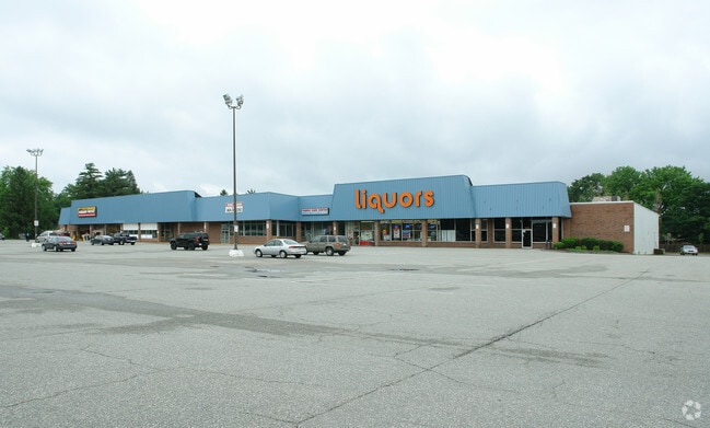
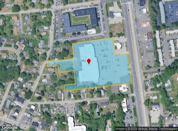
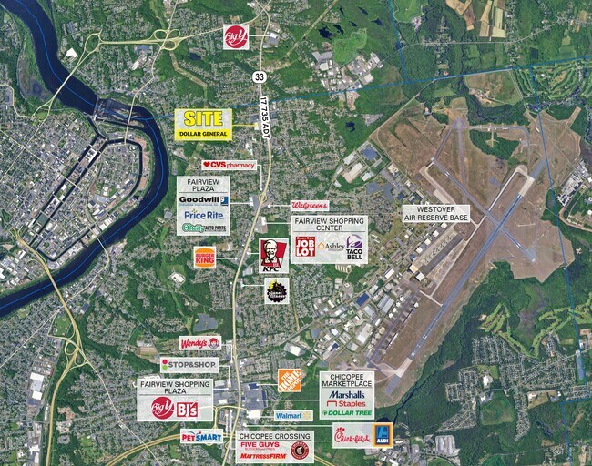
Property Record
1956 Memorial Dr, Chicopee, MA 01020
NEARBY LISTINGS FOR SALE OR LEASE
Property Detail
1956 Memorial Dr
CHIC-000741-000000-000026
Chicopee
Regionalshoppingcenterormallwithanchorstore
Hampden
X
Massachusetts
25013C0204E
6.07 AC
2025
Hampden County
2025
Hartford
811301
Springfield, MA
54,408 SF
DEMOGRAPHICS near 1956 Memorial Dr
1 Mile
3 Mile
5 Mile
2024 Total Population
7,954
60,618
121,214
2029 Population
7,393
57,113
115,754
Pop Growth 2024-2029
(7.05%)
(5.78%)
(4.50%)
Average Age
43
40
41
2024 Total Households
3,583
25,048
49,797
HH Growth 2024-2029
(7.12%)
(6.24%)
(4.82%)
Median Household Inc
$62,058
$51,432
$58,627
Avg Household Size
2.20
2.30
2.30
2024 Avg HH Vehicles
2.00
1.00
2.00
Median Home Value
$256,348
$248,368
$248,837
Median Year Built
1963
1955
1956
Nearby Places
Map Layers
Map Styles
 Street
 Aerial
- Restaurants
- Banks
- Shops
- Fitness
- Groceries
PUBLIC TRANSPORTATION
COMMUTER RAIL
DRIVE
WALK
Distance
7 min
2.4 mi
DRIVE
WALK
Distance
16 min
8.0 mi
AIRPORT
Bradley International
DRIVE
WALK
Distance
Bradley International
47 min
21.9 mi
SALE & LEASE HISTORY
LISTING DATE
SALE/LEASE

Jul 26, 2018
For Sale
Nearby Properties
Address
Land Use
TOTAL SIZE
Lot Size
Zoning
Address
Land Use
TOTAL SIZE
Lot Size
Zoning
22.15 AC
R-1A
Address
Land Use
TOTAL SIZE
Lot Size
Zoning
21.80 AC
106
Address
Land Use
TOTAL SIZE
Lot Size
Zoning
16.30 AC
RA2
Address
Land Use
TOTAL SIZE
Lot Size
Zoning
22.77 AC
111A
Address
Land Use
TOTAL SIZE
Lot Size
Zoning
17.72 AC
R-2
Address
Land Use
TOTAL SIZE
Lot Size
Zoning
171,241 SF
18.94 AC
106
Address
Land Use
TOTAL SIZE
Lot Size
Zoning
30.45 AC
106
Address
Land Use
TOTAL SIZE
Lot Size
Zoning
223,390 SF
13.83 AC
111A
Address
Land Use
TOTAL SIZE
Lot Size
Zoning
26.68 AC
110
Address
Land Use
TOTAL SIZE
Lot Size
Zoning
2.41 AC
DR
Address
Land Use
TOTAL SIZE
Lot Size
Zoning
4.04 AC
107
Address
Land Use
TOTAL SIZE
Lot Size
Zoning
257,179 SF
22.84 AC
110
Address
Land Use
TOTAL SIZE
Lot Size
Zoning
81.65 AC
110
Address
Land Use
TOTAL SIZE
Lot Size
Zoning
320,639 SF
14.16 AC
110
Address
Land Use
TOTAL SIZE
Lot Size
Zoning
23,111 SF
1.43 AC
IA
Address
Land Use
TOTAL SIZE
Lot Size
Zoning
62,808 SF
7.60 AC
R-1
Address
Land Use
TOTAL SIZE
Lot Size
Zoning
491.50 AC
108
Address
Land Use
TOTAL SIZE
Lot Size
Zoning
26.35 AC
RA2
Address
Land Use
TOTAL SIZE
Lot Size
Zoning
194,875 SF
2.75 AC
IG
Address
Land Use
TOTAL SIZE
Lot Size
Zoning
64,638 SF
9.26 AC
RA2
Address
Land Use
TOTAL SIZE
Lot Size
Zoning
14.47 AC
110
Address
Land Use
TOTAL SIZE
Lot Size
Zoning
116,625 SF
12.73 AC
111A
Address
Land Use
TOTAL SIZE
Lot Size
Zoning
5.88 AC
IG
Address
Land Use
TOTAL SIZE
Lot Size
Zoning
43,289 SF
2.63 AC
DR
Address
Land Use
TOTAL SIZE
Lot Size
Zoning
80,393 SF
1.71 AC
111
Address
Land Use
TOTAL SIZE
Lot Size
Zoning
10.62 AC
111A
Address
Land Use
TOTAL SIZE
Lot Size
Zoning
217,640 SF
12.21 AC
110
Address
Land Use
TOTAL SIZE
Lot Size
Zoning
812,675 SF
19.64 AC
BH
Address
Land Use
TOTAL SIZE
Lot Size
Zoning
88,603 SF
3.28 AC
111A
Address
Land Use
TOTAL SIZE
Lot Size
Zoning
3.30 AC
RA2
The World's #1 Commercial Real Estate Marketplace
Connect with us
© 2025 CoStar Group
The information above has been obtained from sources believed reliable. While we do not doubt its accuracy we have not verified it and make no guarantee, warranty or representation about it. It is your responsibility to independently confirm its accuracy and completeness. Any projections, opinions, assumptions, or estimates used are for example only and do not represent the current or future performance of the property. The value of this transaction to you depends on tax and other factors which should be evaluated by your tax, financial, and legal advisors. You and your advisors should conduct a careful, independent investigation of the property to determine to your satisfaction the suitability of the property for your needs.