Property Record
196 E Hampton Rd, Marlborough, CT 06447
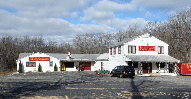

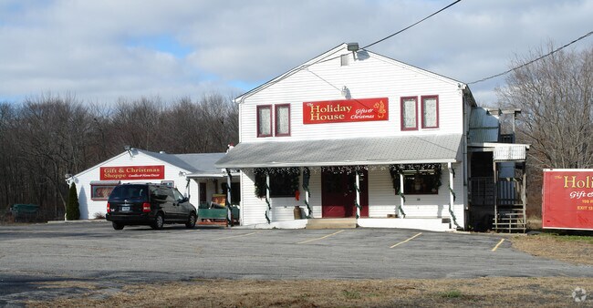
Property Detail
196 E Hampton Rd
MARL-000008-000024-000026C
Capitol
Apartment
Connecticut
R
26c
B and X Area of moderate flood hazard, usually the area between the limits of the 100-year and 500-year floods.
1.16 AC
2024
Marlborough Outlying
2025
Hartford
524100
Hartford-West Hartford-East Hartford, CT
8,352 SF
NEARBY LISTINGS FOR SALE OR LEASE
DEMOGRAPHICS near 196 E Hampton Rd
1 mile
3 mile
5 mile
2025 Total Population
917
12,035
21,199
2030 Population
941
12,241
21,527
Pop Growth 2025-2030
+ 2.62%
+ 1.71%
+ 1.55%
Average Age
45
44
43
2025 Total Households
388
4,874
8,298
HH Growth 2025-2030
+ 2.58%
+ 1.70%
+ 1.53%
Median Household Inc
$120,468
$115,624
$125,153
Avg Household Size
2.30
2.40
2.50
2025 Avg HH Vehicles
2.00
2.00
2.00
Median Home Value
$356,999
$350,248
$370,258
Median Year Built
1975
1976
1978
Nearby Places
Map Layers
Map Styles
 Street
 Aerial
Transit
 Traffic
 Biking
Places
Listings with unknown addresses are not visible on the map
- Restaurants
- Banks
- Shops
- Fitness
- Groceries
PUBLIC TRANSPORTATION
AIRPORT
Bradley International
Drive
Walk
Distance
Bradley International
48 min
32.1 mi
Tweed/New Haven
Drive
Walk
Distance
Tweed/New Haven
66 min
41.2 mi
Freight Ports
Port of New Haven
Drive
Walk
Distance
Port of New Haven
61 min
40.0 mi
Nearby Properties
Address
Land Use
TOTAL SIZE
Lot Size
Zoning
Address
Land Use
TOTAL SIZE
Lot Size
Zoning
127,409 SF
46.70 AC
R-1S
Address
Land Use
TOTAL SIZE
Lot Size
Zoning
12.12 AC
DC
Address
Land Use
TOTAL SIZE
Lot Size
Zoning
81,933 SF
20.65 AC
R
Address
Land Use
TOTAL SIZE
Lot Size
Zoning
81,849 SF
15 AC
R-2
Address
Land Use
TOTAL SIZE
Lot Size
Zoning
11.13 AC
C
Address
Land Use
TOTAL SIZE
Lot Size
Zoning
2.98 AC
C
Address
Land Use
TOTAL SIZE
Lot Size
Zoning
36,865 SF
6.76 AC
R-1S
Address
Land Use
TOTAL SIZE
Lot Size
Zoning
17,000 SF
3.98 AC
R-2S
Address
Land Use
TOTAL SIZE
Lot Size
Zoning
16,767 SF
GC
Address
Land Use
TOTAL SIZE
Lot Size
Zoning
16,767 SF
Address
Land Use
TOTAL SIZE
Lot Size
Zoning
10.53 AC
R-2S
Address
Land Use
TOTAL SIZE
Lot Size
Zoning
19,210 SF
1.85 AC
C
Address
Land Use
TOTAL SIZE
Lot Size
Zoning
36,379 SF
10.98 AC
R
Address
Land Use
TOTAL SIZE
Lot Size
Zoning
39,482 SF
2.54 AC
I
Address
Land Use
TOTAL SIZE
Lot Size
Zoning
18,345 SF
5.40 AC
C
Address
Land Use
TOTAL SIZE
Lot Size
Zoning
16,270 SF
3.01 AC
VC
Address
Land Use
TOTAL SIZE
Lot Size
Zoning
2.96 AC
PO/R
Address
Land Use
TOTAL SIZE
Lot Size
Zoning
Address
Land Use
TOTAL SIZE
Lot Size
Zoning
25,864 SF
22.90 AC
DMR
Address
Land Use
TOTAL SIZE
Lot Size
Zoning
1.70 AC
C
Address
Land Use
TOTAL SIZE
Lot Size
Zoning
Address
Land Use
TOTAL SIZE
Lot Size
Zoning
483.45 AC
R-3
Address
Land Use
TOTAL SIZE
Lot Size
Zoning
4.96 AC
R-2S
Address
Land Use
TOTAL SIZE
Lot Size
Zoning
36.02 AC
R
Address
Land Use
TOTAL SIZE
Lot Size
Zoning
17,472 SF
0.66 AC
DD
Address
Land Use
TOTAL SIZE
Lot Size
Zoning
17,472 SF
0.65 AC
DD
Address
Land Use
TOTAL SIZE
Lot Size
Zoning
4.79 AC
R
Address
Land Use
TOTAL SIZE
Lot Size
Zoning
17,000 SF
5.28 AC
DD
Address
Land Use
TOTAL SIZE
Lot Size
Zoning
8,910 SF
5.71 AC
GC
Address
Land Use
TOTAL SIZE
Lot Size
Zoning
11,442 SF
2.20 AC
GC
The World's #1 Commercial Real Estate Marketplace
Connect with us
© 2026 CoStar Group
The information above has been obtained from sources believed reliable. While we do not doubt its accuracy we have not verified it and make no guarantee, warranty or representation about it. It is your responsibility to independently confirm its accuracy and completeness. Any projections, opinions, assumptions, or estimates used are for example only and do not represent the current or future performance of the property. The value of this transaction to you depends on tax and other factors which should be evaluated by your tax, financial, and legal advisors. You and your advisors should conduct a careful, independent investigation of the property to determine to your satisfaction the suitability of the property for your needs.