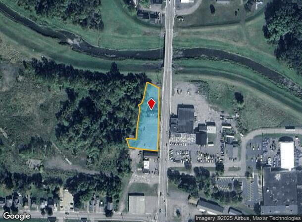
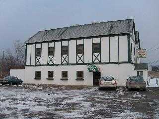
Property Record
196 Seneca St, Hornell, NY 14843

NEARBY LISTINGS FOR SALE OR LEASE
Property Detail
196 Seneca St
Corning, NY
TS 10/99
460600-151-010-0001-042-100
Steuben
Restaurantbuilding
New York
2025
42.100
2024
0.79 AC
960700
Ithaca/Elmira
8,272 SF
Other Market Areas
DEMOGRAPHICS near 196 Seneca St
1 Mile
3 Mile
5 Mile
2024 Total Population
4,535
10,534
13,264
2029 Population
4,436
10,320
13,052
Pop Growth 2024-2029
(2.18%)
(2.03%)
(1.60%)
Average Age
41
41
42
2024 Total Households
1,993
4,550
5,730
HH Growth 2024-2029
(2.21%)
(2.07%)
(1.66%)
Median Household Inc
$46,300
$48,497
$50,859
Avg Household Size
2.20
2.20
2.20
2024 Avg HH Vehicles
1.00
1.00
2.00
Median Home Value
$84,782
$91,437
$96,881
Median Year Built
1948
1948
1949
Nearby Places
- Restaurants
- Banks
- Shops
- Fitness
- Groceries
SALE & LEASE HISTORY
LISTING DATE
SALE/LEASE

Sep 23, 2016
For Sale
Nearby Properties
Address
Land Use
TOTAL SIZE
Lot Size
Zoning
Address
Land Use
TOTAL SIZE
Lot Size
Zoning
146,000 SF
7.35 AC
I-1
Address
Land Use
TOTAL SIZE
Lot Size
Zoning
81,633 SF
13.10 AC
B-2
Address
Land Use
TOTAL SIZE
Lot Size
Zoning
128,268 SF
16.67 AC
B-2
Address
Land Use
TOTAL SIZE
Lot Size
Zoning
127,500 SF
8.50 AC
Address
Land Use
TOTAL SIZE
Lot Size
Zoning
111,348 SF
34.66 AC
B-2
Address
Land Use
TOTAL SIZE
Lot Size
Zoning
114,774 SF
12.11 AC
05
Address
Land Use
TOTAL SIZE
Lot Size
Zoning
216.30 AC
Address
Land Use
TOTAL SIZE
Lot Size
Zoning
77,265 SF
35.46 AC
05
Address
Land Use
TOTAL SIZE
Lot Size
Zoning
152,409 SF
2.40 AC
Address
Land Use
TOTAL SIZE
Lot Size
Zoning
50,760 SF
2.30 AC
Address
Land Use
TOTAL SIZE
Lot Size
Zoning
42,000 SF
2.93 AC
Address
Land Use
TOTAL SIZE
Lot Size
Zoning
51,919 SF
4 AC
B-2
Address
Land Use
TOTAL SIZE
Lot Size
Zoning
27.85 AC
I-2
Address
Land Use
TOTAL SIZE
Lot Size
Zoning
75,499 SF
48.43 AC
05
Address
Land Use
TOTAL SIZE
Lot Size
Zoning
50,883 SF
32 AC
08
Address
Land Use
TOTAL SIZE
Lot Size
Zoning
131,969 SF
7.70 AC
Address
Land Use
TOTAL SIZE
Lot Size
Zoning
70,000 SF
28.70 AC
I-1
Address
Land Use
TOTAL SIZE
Lot Size
Zoning
147,500 SF
3.58 AC
B-1
Address
Land Use
TOTAL SIZE
Lot Size
Zoning
6,516 SF
5.76 AC
Address
Land Use
TOTAL SIZE
Lot Size
Zoning
49,040 SF
15.20 AC
06
Address
Land Use
TOTAL SIZE
Lot Size
Zoning
800 SF
15.71 AC
05
Address
Land Use
TOTAL SIZE
Lot Size
Zoning
10,504 SF
6.30 AC
B-2
Address
Land Use
TOTAL SIZE
Lot Size
Zoning
55,137 SF
7.64 AC
Address
Land Use
TOTAL SIZE
Lot Size
Zoning
62,484 SF
5.40 AC
I-2
Address
Land Use
TOTAL SIZE
Lot Size
Zoning
103,138 SF
17.50 AC
05
Address
Land Use
TOTAL SIZE
Lot Size
Zoning
13,776 SF
1.71 AC
B-2
Address
Land Use
TOTAL SIZE
Lot Size
Zoning
28,634 SF
5.42 AC
B-2
Address
Land Use
TOTAL SIZE
Lot Size
Zoning
13,350 SF
1.50 AC
05
Address
Land Use
TOTAL SIZE
Lot Size
Zoning
6,056 SF
3.50 AC
R-3
Address
Land Use
TOTAL SIZE
Lot Size
Zoning
36,118 SF
1.62 AC
The World's #1 Commercial Real Estate Marketplace
Connect with us
© 2025 CoStar Group
The information above has been obtained from sources believed reliable. While we do not doubt its accuracy we have not verified it and make no guarantee, warranty or representation about it. It is your responsibility to independently confirm its accuracy and completeness. Any projections, opinions, assumptions, or estimates used are for example only and do not represent the current or future performance of the property. The value of this transaction to you depends on tax and other factors which should be evaluated by your tax, financial, and legal advisors. You and your advisors should conduct a careful, independent investigation of the property to determine to your satisfaction the suitability of the property for your needs.