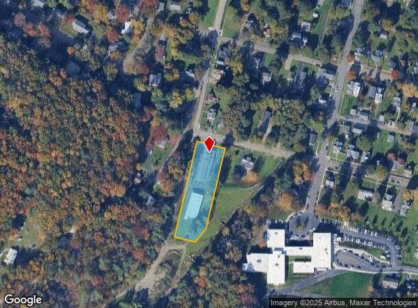
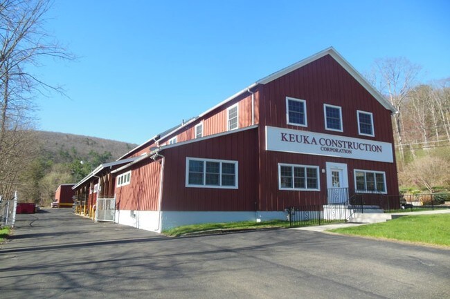
Property Record
196 W 6Th St, Corning, NY 14830

NEARBY LISTINGS FOR SALE OR LEASE
Property Detail
196 W 6Th St
Corning, NY
MAP 30 BLOCK 94 LOTS 1&2 126X165
460300-317-016-0001-070-000
Steuben
Warehouse
New York
2025
70.000
2024
1.17 AC
962600
Other Market Areas
8,590 SF
DEMOGRAPHICS near 196 W 6Th St
1 Mile
3 Mile
5 Mile
2024 Total Population
4,396
17,020
23,679
2029 Population
4,295
16,582
23,105
Pop Growth 2024-2029
(2.30%)
(2.57%)
(2.42%)
Average Age
39
41
41
2024 Total Households
2,015
7,700
10,442
HH Growth 2024-2029
(2.38%)
(2.64%)
(2.49%)
Median Household Inc
$68,254
$62,472
$71,412
Avg Household Size
2.10
2.10
2.20
2024 Avg HH Vehicles
1.00
2.00
2.00
Median Home Value
$149,750
$150,548
$158,190
Median Year Built
1947
1951
1958
Nearby Places
- Restaurants
- Banks
- Shops
- Fitness
- Groceries
PUBLIC TRANSPORTATION
AIRPORT
Elmira/Corning Regional
DRIVE
WALK
Distance
Elmira/Corning Regional
19 min
11.2 mi
Freight Ports
Albany, NY Port
DRIVE
WALK
Distance
Albany, NY Port
255 min
212.9 mi
SALE & LEASE HISTORY
LISTING DATE
SALE/LEASE

Feb 11, 2019
For Sale
Nearby Properties
Address
Land Use
TOTAL SIZE
Lot Size
Zoning
Address
Land Use
TOTAL SIZE
Lot Size
Zoning
52,288 SF
9.50 AC
BD
Address
Land Use
TOTAL SIZE
Lot Size
Zoning
302,250 SF
19.74 AC
BD
Address
Land Use
TOTAL SIZE
Lot Size
Zoning
Address
Land Use
TOTAL SIZE
Lot Size
Zoning
192,620 SF
31.50 AC
05 - COMME
Address
Land Use
TOTAL SIZE
Lot Size
Zoning
27,603 SF
90.91 AC
CONF
Address
Land Use
TOTAL SIZE
Lot Size
Zoning
Address
Land Use
TOTAL SIZE
Lot Size
Zoning
17,717 SF
205.78 AC
CONF
Address
Land Use
TOTAL SIZE
Lot Size
Zoning
279,299 SF
6.72 AC
PC
Address
Land Use
TOTAL SIZE
Lot Size
Zoning
78,653 SF
4.06 AC
BD
Address
Land Use
TOTAL SIZE
Lot Size
Zoning
150,000 SF
17.94 AC
05
Address
Land Use
TOTAL SIZE
Lot Size
Zoning
3.32 AC
C
Address
Land Use
TOTAL SIZE
Lot Size
Zoning
81,728 SF
4.03 AC
BD
Address
Land Use
TOTAL SIZE
Lot Size
Zoning
97,110 SF
13.31 AC
C
Address
Land Use
TOTAL SIZE
Lot Size
Zoning
82,123 SF
1.35 AC
C
Address
Land Use
TOTAL SIZE
Lot Size
Zoning
90,947 SF
2.79 AC
C
Address
Land Use
TOTAL SIZE
Lot Size
Zoning
43,869 SF
5.02 AC
BD
Address
Land Use
TOTAL SIZE
Lot Size
Zoning
Address
Land Use
TOTAL SIZE
Lot Size
Zoning
Address
Land Use
TOTAL SIZE
Lot Size
Zoning
8,546 SF
31.88 AC
07 - MIXED
Address
Land Use
TOTAL SIZE
Lot Size
Zoning
48,040 SF
12.11 AC
BD
Address
Land Use
TOTAL SIZE
Lot Size
Zoning
20.37 AC
07 - MIXED
Address
Land Use
TOTAL SIZE
Lot Size
Zoning
82,146 SF
2.60 AC
R2
Address
Land Use
TOTAL SIZE
Lot Size
Zoning
46,800 SF
6.39 AC
07 - MIXED
Address
Land Use
TOTAL SIZE
Lot Size
Zoning
18,524 SF
2.86 AC
C
Address
Land Use
TOTAL SIZE
Lot Size
Zoning
242,379 SF
4.30 AC
BD
Address
Land Use
TOTAL SIZE
Lot Size
Zoning
94,984 SF
11.62 AC
Address
Land Use
TOTAL SIZE
Lot Size
Zoning
49,384 SF
1.19 AC
C
Address
Land Use
TOTAL SIZE
Lot Size
Zoning
29,752 SF
0.33 AC
C
Address
Land Use
TOTAL SIZE
Lot Size
Zoning
55,981 SF
8 AC
05 - COMME
Address
Land Use
TOTAL SIZE
Lot Size
Zoning
84,356 SF
2.46 AC
MR
The World's #1 Commercial Real Estate Marketplace
Connect with us
© 2025 CoStar Group
The information above has been obtained from sources believed reliable. While we do not doubt its accuracy we have not verified it and make no guarantee, warranty or representation about it. It is your responsibility to independently confirm its accuracy and completeness. Any projections, opinions, assumptions, or estimates used are for example only and do not represent the current or future performance of the property. The value of this transaction to you depends on tax and other factors which should be evaluated by your tax, financial, and legal advisors. You and your advisors should conduct a careful, independent investigation of the property to determine to your satisfaction the suitability of the property for your needs.