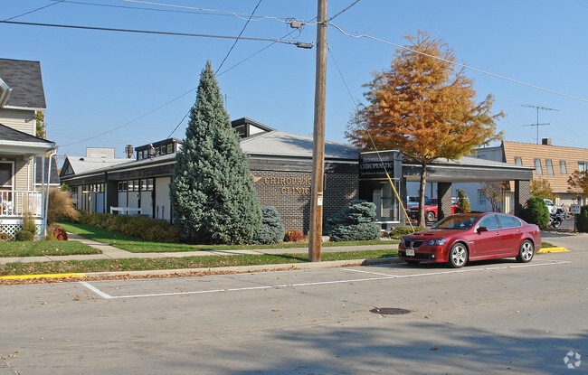
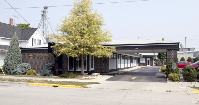
Property Record
196 W Chestnut St, Burlington, WI 53105

NEARBY LISTINGS FOR SALE OR LEASE
Property Detail
196 W Chestnut St
206-031932024000
PT NW1/4 COM ON N LN OF CHESTNUT ST 130 NW OF SWLY CORNER OF BLK 3 PERKINS ADD CONT ALG N LN CHESTNUT ST NW63 TO ELY LN BLK 1 OF MORRIS ADD TH NE132 SE63SW TO POB
Commercialnec
Racine
X
Wisconsin
55101C0142E
0.19 AC
2024
Racine West
2024
Milwaukee/Madison
002401
Racine-Mount Pleasant, WI
1,911 SF
DEMOGRAPHICS near 196 W Chestnut St
1 Mile
3 Mile
5 Mile
2024 Total Population
8,010
15,237
22,845
2029 Population
7,985
15,198
22,724
Pop Growth 2024-2029
(0.31%)
(0.26%)
(0.53%)
Average Age
40
41
42
2024 Total Households
3,304
6,220
9,244
HH Growth 2024-2029
(0.42%)
(0.31%)
(0.58%)
Median Household Inc
$78,688
$83,389
$83,030
Avg Household Size
2.40
2.40
2.40
2024 Avg HH Vehicles
2.00
2.00
2.00
Median Home Value
$246,548
$267,717
$278,061
Median Year Built
1971
1973
1974
Nearby Places
Map Layers
Map Styles
 Street
 Aerial
- Restaurants
- Banks
- Shops
- Fitness
- Groceries
PUBLIC TRANSPORTATION
AIRPORT
General Mitchell International
DRIVE
WALK
Distance
General Mitchell International
48 min
37.0 mi
Freight Ports
Port Milwaukee
DRIVE
WALK
Distance
Port Milwaukee
51 min
32.2 mi
Nearby Properties
Address
Land Use
TOTAL SIZE
Lot Size
Zoning
Address
Land Use
TOTAL SIZE
Lot Size
Zoning
164,700 SF
0.97 AC
Address
Land Use
TOTAL SIZE
Lot Size
Zoning
6.08 AC
Address
Land Use
TOTAL SIZE
Lot Size
Zoning
42.50 AC
Address
Land Use
TOTAL SIZE
Lot Size
Zoning
155,078 SF
27.98 AC
Address
Land Use
TOTAL SIZE
Lot Size
Zoning
22.08 AC
Address
Land Use
TOTAL SIZE
Lot Size
Zoning
48,105 SF
0.39 AC
Address
Land Use
TOTAL SIZE
Lot Size
Zoning
15,776 SF
8.97 AC
Address
Land Use
TOTAL SIZE
Lot Size
Zoning
11.76 AC
Address
Land Use
TOTAL SIZE
Lot Size
Zoning
69,915 SF
0.54 AC
Address
Land Use
TOTAL SIZE
Lot Size
Zoning
48,326 SF
5.65 AC
Address
Land Use
TOTAL SIZE
Lot Size
Zoning
13,616 SF
6.19 AC
Address
Land Use
TOTAL SIZE
Lot Size
Zoning
62.77 AC
Address
Land Use
TOTAL SIZE
Lot Size
Zoning
26.11 AC
Address
Land Use
TOTAL SIZE
Lot Size
Zoning
Address
Land Use
TOTAL SIZE
Lot Size
Zoning
10.17 AC
Address
Land Use
TOTAL SIZE
Lot Size
Zoning
39,600 SF
0.47 AC
Address
Land Use
TOTAL SIZE
Lot Size
Zoning
12.03 AC
Address
Land Use
TOTAL SIZE
Lot Size
Zoning
22.70 AC
Address
Land Use
TOTAL SIZE
Lot Size
Zoning
22,670 SF
4.22 AC
Address
Land Use
TOTAL SIZE
Lot Size
Zoning
6.89 AC
Address
Land Use
TOTAL SIZE
Lot Size
Zoning
99,779 SF
0.75 AC
Address
Land Use
TOTAL SIZE
Lot Size
Zoning
40,432 SF
3.84 AC
Address
Land Use
TOTAL SIZE
Lot Size
Zoning
Address
Land Use
TOTAL SIZE
Lot Size
Zoning
952 SF
0.79 AC
Address
Land Use
TOTAL SIZE
Lot Size
Zoning
10.12 AC
Address
Land Use
TOTAL SIZE
Lot Size
Zoning
21,564 SF
0.95 AC
Address
Land Use
TOTAL SIZE
Lot Size
Zoning
68,900 SF
6.29 AC
Address
Land Use
TOTAL SIZE
Lot Size
Zoning
Address
Land Use
TOTAL SIZE
Lot Size
Zoning
13,200 SF
17.20 AC
The World's #1 Commercial Real Estate Marketplace
Connect with us
© 2026 CoStar Group
The information above has been obtained from sources believed reliable. While we do not doubt its accuracy we have not verified it and make no guarantee, warranty or representation about it. It is your responsibility to independently confirm its accuracy and completeness. Any projections, opinions, assumptions, or estimates used are for example only and do not represent the current or future performance of the property. The value of this transaction to you depends on tax and other factors which should be evaluated by your tax, financial, and legal advisors. You and your advisors should conduct a careful, independent investigation of the property to determine to your satisfaction the suitability of the property for your needs.