Property Record
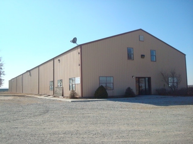
1960 1/3 Highway 127, La Monte, MO 65337

Property Detail
1960 1/3 Highway 127
Sedalia, MO
BEG NE COR NWSW S 417.42' W 417.42' N 417.42' E 417.42' (EX RD) 2 46 23
121002000003000
PETTIS
Commercialnec
Missouri
2025
3.40 AC
2024
Missouri North Area
480200
Other Market Areas
13,200 SF
NEARBY LISTINGS FOR SALE OR LEASE
-
-
View all La Monte listings for sale on LoopNet.com
DEMOGRAPHICS near 1960 1/3 Highway 127
1 mile
3 mile
5 mile
2025 Total Population
41
1,351
1,949
2030 Population
42
1,383
1,989
Pop Growth 2025-2030
+ 2.44%
+ 2.37%
+ 2.05%
Average Age
41
38
39
2025 Total Households
15
476
692
HH Growth 2025-2030
0.00%
+ 2.31%
+ 2.02%
Median Household Inc
$67,500
$62,444
$64,754
Avg Household Size
2.70
2.70
2.70
2025 Avg HH Vehicles
3.00
2.00
2.00
Median Home Value
$199,999
$142,126
$169,552
Median Year Built
1979
1970
1973
Nearby Places
Map Layers
Map Styles
 Street
 Aerial
Layers
 Traffic
 Biking
Places
Listings with unknown addresses are not visible on the map
- Restaurants
- Banks
- Shops
- Fitness
- Groceries
Nearby Properties
Address
Land Use
TOTAL SIZE
Lot Size
Zoning
Address
Land Use
TOTAL SIZE
Lot Size
Zoning
3,500 SF
4.86 AC
Address
Land Use
TOTAL SIZE
Lot Size
Zoning
9,100 SF
0.88 AC
Address
Land Use
TOTAL SIZE
Lot Size
Zoning
7,435 SF
0.91 AC
Address
Land Use
TOTAL SIZE
Lot Size
Zoning
7,500 SF
4.04 AC
Address
Land Use
TOTAL SIZE
Lot Size
Zoning
2,216 SF
1.15 AC
Address
Land Use
TOTAL SIZE
Lot Size
Zoning
3,288 SF
0.98 AC
Address
Land Use
TOTAL SIZE
Lot Size
Zoning
2,828 SF
0.41 AC
Address
Land Use
TOTAL SIZE
Lot Size
Zoning
1,498 SF
78.02 AC
Address
Land Use
TOTAL SIZE
Lot Size
Zoning
136 SF
3.14 AC
Address
Land Use
TOTAL SIZE
Lot Size
Zoning
5,400 SF
0.33 AC
Address
Land Use
TOTAL SIZE
Lot Size
Zoning
1,560 SF
1.73 AC
Address
Land Use
TOTAL SIZE
Lot Size
Zoning
6,000 SF
0.73 AC
Address
Land Use
TOTAL SIZE
Lot Size
Zoning
2,127 SF
250.30 AC
Address
Land Use
TOTAL SIZE
Lot Size
Zoning
6,090 SF
0.67 AC
Address
Land Use
TOTAL SIZE
Lot Size
Zoning
2,324 SF
0.41 AC
Address
Land Use
TOTAL SIZE
Lot Size
Zoning
1,305 SF
195.12 AC
Address
Land Use
TOTAL SIZE
Lot Size
Zoning
9,614 SF
1 AC
Address
Land Use
TOTAL SIZE
Lot Size
Zoning
2,800 SF
4.13 AC
Address
Land Use
TOTAL SIZE
Lot Size
Zoning
Address
Land Use
TOTAL SIZE
Lot Size
Zoning
1,506 SF
0.23 AC
Address
Land Use
TOTAL SIZE
Lot Size
Zoning
960 SF
0.24 AC
Address
Land Use
TOTAL SIZE
Lot Size
Zoning
Address
Land Use
TOTAL SIZE
Lot Size
Zoning
360 SF
176.70 AC
Address
Land Use
TOTAL SIZE
Lot Size
Zoning
1,400 SF
0.34 AC
Address
Land Use
TOTAL SIZE
Lot Size
Zoning
300 SF
439.50 AC
Address
Land Use
TOTAL SIZE
Lot Size
Zoning
3,867 SF
158 AC
Address
Land Use
TOTAL SIZE
Lot Size
Zoning
5,016 SF
257 AC
Address
Land Use
TOTAL SIZE
Lot Size
Zoning
243.20 AC
Address
Land Use
TOTAL SIZE
Lot Size
Zoning
The World's #1 Commercial Real Estate Marketplace
Connect with us
© 2026 CoStar Group
The information above has been obtained from sources believed reliable. While we do not doubt its accuracy we have not verified it and make no guarantee, warranty or representation about it. It is your responsibility to independently confirm its accuracy and completeness. Any projections, opinions, assumptions, or estimates used are for example only and do not represent the current or future performance of the property. The value of this transaction to you depends on tax and other factors which should be evaluated by your tax, financial, and legal advisors. You and your advisors should conduct a careful, independent investigation of the property to determine to your satisfaction the suitability of the property for your needs.