Property Record
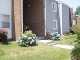
1960 Boone St, Rocky Mount, NC 27803

NEARBY LISTINGS FOR SALE OR LEASE
-
-
View all Rocky Mount listings for sale on LoopNet.com
Property Detail
1960 Boone St
3759-17-11-5361
95 2 1, 10 51 AC, LINDSEY BOONE 28 AC 1C LINDSEY BOONE 28
Gardenaptcourtapt5plusunits
Nash
AE
North Carolina
3720375900K
10.51 AC
2025
Rocky Mount/Wilson
2025
Other Market Areas
010200
Rocky Mount, NC
1,298 SF
DEMOGRAPHICS near 1960 Boone St
1 Mile
3 Mile
5 Mile
2024 Total Population
6,196
29,117
53,904
2029 Population
6,419
29,855
55,010
Pop Growth 2024-2029
+ 3.60%
+ 2.53%
+ 2.05%
Average Age
38
41
41
2024 Total Households
2,619
12,299
23,020
HH Growth 2024-2029
+ 3.55%
+ 2.60%
+ 2.09%
Median Household Inc
$25,827
$37,152
$44,406
Avg Household Size
2.30
2.30
2.30
2024 Avg HH Vehicles
1.00
2.00
2.00
Median Home Value
$84,896
$97,622
$133,247
Median Year Built
1970
1969
1977
Nearby Places
Map Layers
Map Styles
 Street
 Aerial
- Restaurants
- Banks
- Shops
- Fitness
- Groceries
PUBLIC TRANSPORTATION
COMMUTER RAIL
Rocky Mount (Carolinian - Amtrak, Palmetto - Amtrak, Silver Meteor - Amtrak, Silver Star - Amtrak)
DRIVE
WALK
Distance
Rocky Mount (Carolinian - Amtrak, Palmetto - Amtrak, Silver Meteor - Amtrak, Silver Star - Amtrak)
4 min
1.9 mi
Freight Ports
Port of Morehead City
DRIVE
WALK
Distance
Port of Morehead City
183 min
134.9 mi
Nearby Properties
Address
Land Use
TOTAL SIZE
Lot Size
Zoning
Address
Land Use
TOTAL SIZE
Lot Size
Zoning
7,020 SF
33.70 AC
R6
Address
Land Use
TOTAL SIZE
Lot Size
Zoning
129,595 SF
11.35 AC
B2CU
Address
Land Use
TOTAL SIZE
Lot Size
Zoning
130,639 SF
60.52 AC
A1M
Address
Land Use
TOTAL SIZE
Lot Size
Zoning
10,632 SF
16.61 AC
R6
Address
Land Use
TOTAL SIZE
Lot Size
Zoning
79,027 SF
33.37 AC
R10
Address
Land Use
TOTAL SIZE
Lot Size
Zoning
165,000 SF
4.66 AC
Address
Land Use
TOTAL SIZE
Lot Size
Zoning
29,504 SF
18.61 AC
Address
Land Use
TOTAL SIZE
Lot Size
Zoning
8,216 SF
4.21 AC
B4
Address
Land Use
TOTAL SIZE
Lot Size
Zoning
32,051 SF
18.50 AC
R6
Address
Land Use
TOTAL SIZE
Lot Size
Zoning
15,650 SF
32.25 AC
R10
Address
Land Use
TOTAL SIZE
Lot Size
Zoning
47,968 SF
4.68 AC
I
Address
Land Use
TOTAL SIZE
Lot Size
Zoning
118,800 SF
5.51 AC
I
Address
Land Use
TOTAL SIZE
Lot Size
Zoning
13,075 SF
14.90 AC
Address
Land Use
TOTAL SIZE
Lot Size
Zoning
6,253 SF
16.22 AC
A1
Address
Land Use
TOTAL SIZE
Lot Size
Zoning
42,449 SF
2.49 AC
I2
Address
Land Use
TOTAL SIZE
Lot Size
Zoning
26,401 SF
7.50 AC
R10
Address
Land Use
TOTAL SIZE
Lot Size
Zoning
30,481 SF
4.14 AC
Address
Land Use
TOTAL SIZE
Lot Size
Zoning
3,360 SF
6.27 AC
R10
Address
Land Use
TOTAL SIZE
Lot Size
Zoning
2,888 SF
3.35 AC
Address
Land Use
TOTAL SIZE
Lot Size
Zoning
29,187 SF
29.05 AC
R10
Address
Land Use
TOTAL SIZE
Lot Size
Zoning
52,789 SF
21.90 AC
I2
Address
Land Use
TOTAL SIZE
Lot Size
Zoning
42,113 SF
1.13 AC
B4
Address
Land Use
TOTAL SIZE
Lot Size
Zoning
Address
Land Use
TOTAL SIZE
Lot Size
Zoning
32,583 SF
12.62 AC
I2
Address
Land Use
TOTAL SIZE
Lot Size
Zoning
50,384 SF
1.92 AC
B4
Address
Land Use
TOTAL SIZE
Lot Size
Zoning
109,400 SF
12.91 AC
B2
Address
Land Use
TOTAL SIZE
Lot Size
Zoning
38,041 SF
1.18 AC
B4
Address
Land Use
TOTAL SIZE
Lot Size
Zoning
55,934 SF
2 AC
B5
Address
Land Use
TOTAL SIZE
Lot Size
Zoning
11,708 SF
6.10 AC
R10
The World's #1 Commercial Real Estate Marketplace
Connect with us
© 2026 CoStar Group
The information above has been obtained from sources believed reliable. While we do not doubt its accuracy we have not verified it and make no guarantee, warranty or representation about it. It is your responsibility to independently confirm its accuracy and completeness. Any projections, opinions, assumptions, or estimates used are for example only and do not represent the current or future performance of the property. The value of this transaction to you depends on tax and other factors which should be evaluated by your tax, financial, and legal advisors. You and your advisors should conduct a careful, independent investigation of the property to determine to your satisfaction the suitability of the property for your needs.