Property Record
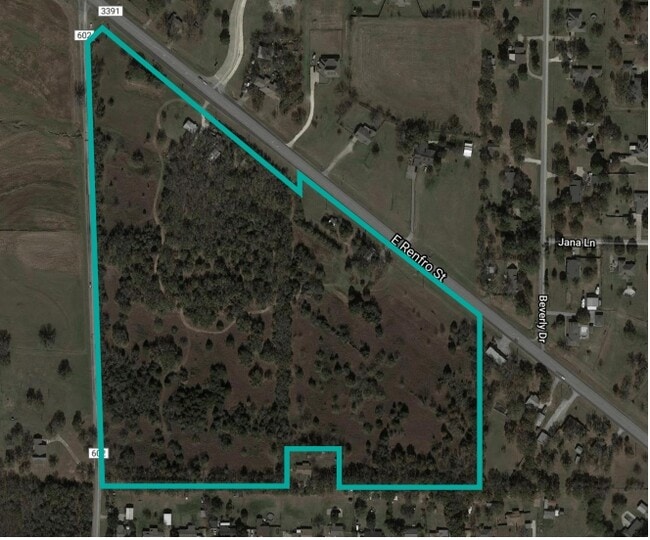
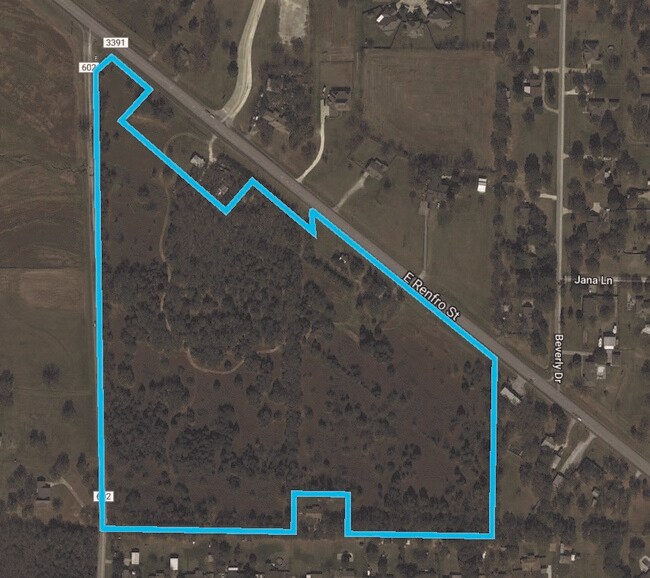
1960 E Renfro St, Burleson, TX 76028
Property Detail
1960 E Renfro St
126-0284-00130
ABST 284 TR 16 A FOSTER 126.0284.00272 UDI NO EXEMPT
Farms
Johnson
B and X Area of moderate flood hazard, usually the area between the limits of the 100-year and 500-year floods.
Texas
2024
16.76 AC
2025
Johnson County
130406
Dallas/Ft Worth
1,186 SF
Dallas-Fort Worth-Arlington, TX
NEARBY LISTINGS FOR SALE OR LEASE
DEMOGRAPHICS near 1960 E Renfro St
1 mile
3 mile
5 mile
2025 Total Population
2,654
22,777
76,111
2030 Population
2,993
25,507
83,970
Pop Growth 2025-2030
+ 12.77%
+ 11.99%
+ 10.33%
Average Age
42
41
39
2025 Total Households
928
8,063
26,897
HH Growth 2025-2030
+ 12.39%
+ 11.71%
+ 10.22%
Median Household Inc
$132,218
$109,723
$97,105
Avg Household Size
2.80
2.80
2.80
2025 Avg HH Vehicles
2.00
2.00
2.00
Median Home Value
$425,750
$402,004
$347,677
Median Year Built
1992
1995
1997
Nearby Places
Map Layers
Map Styles
 Street
 Aerial
Layers
 Traffic
 Biking
Places
Listings with unknown addresses are not visible on the map
- Restaurants
- Banks
- Shops
- Fitness
- Groceries
PUBLIC TRANSPORTATION
AIRPORT
Dallas-Fort Worth International
Drive
Walk
Distance
Dallas-Fort Worth International
53 min
41.6 mi
Freight Ports
Port of Shreveport
Drive
Walk
Distance
Port of Shreveport
257 min
238.3 mi
SALE & LEASE HISTORY
LISTING DATE
SALE/LEASE

Jul 21, 2021
For Sale
Nearby Properties
Address
Land Use
TOTAL SIZE
Lot Size
Zoning
Address
Land Use
TOTAL SIZE
Lot Size
Zoning
151.01 AC
Address
Land Use
TOTAL SIZE
Lot Size
Zoning
840 SF
41.70 AC
Address
Land Use
TOTAL SIZE
Lot Size
Zoning
11.95 AC
Address
Land Use
TOTAL SIZE
Lot Size
Zoning
178,582 SF
8.03 AC
Address
Land Use
TOTAL SIZE
Lot Size
Zoning
114,308 SF
9.73 AC
Address
Land Use
TOTAL SIZE
Lot Size
Zoning
66,892 SF
115.97 AC
Address
Land Use
TOTAL SIZE
Lot Size
Zoning
9,207 SF
15.38 AC
Address
Land Use
TOTAL SIZE
Lot Size
Zoning
5,277 SF
218.92 AC
Address
Land Use
TOTAL SIZE
Lot Size
Zoning
62,479 SF
20.89 AC
Address
Land Use
TOTAL SIZE
Lot Size
Zoning
66,733 SF
11.15 AC
Address
Land Use
TOTAL SIZE
Lot Size
Zoning
38,084 SF
12.98 AC
Address
Land Use
TOTAL SIZE
Lot Size
Zoning
47,005 SF
6.85 AC
Address
Land Use
TOTAL SIZE
Lot Size
Zoning
26.37 AC
Address
Land Use
TOTAL SIZE
Lot Size
Zoning
27,850 SF
0.24 AC
Address
Land Use
TOTAL SIZE
Lot Size
Zoning
22,252 SF
8.80 AC
Address
Land Use
TOTAL SIZE
Lot Size
Zoning
39,432 SF
1.99 AC
Address
Land Use
TOTAL SIZE
Lot Size
Zoning
28,909 SF
8.29 AC
Address
Land Use
TOTAL SIZE
Lot Size
Zoning
45,285 SF
19.97 AC
Address
Land Use
TOTAL SIZE
Lot Size
Zoning
16,432 SF
5.15 AC
Address
Land Use
TOTAL SIZE
Lot Size
Zoning
48,636 SF
1.56 AC
Address
Land Use
TOTAL SIZE
Lot Size
Zoning
17,322 SF
7.26 AC
Address
Land Use
TOTAL SIZE
Lot Size
Zoning
15,518 SF
14.52 AC
Address
Land Use
TOTAL SIZE
Lot Size
Zoning
Address
Land Use
TOTAL SIZE
Lot Size
Zoning
33,520 SF
6.11 AC
Address
Land Use
TOTAL SIZE
Lot Size
Zoning
20,283 SF
0.14 AC
Address
Land Use
TOTAL SIZE
Lot Size
Zoning
24,966 SF
3.76 AC
Address
Land Use
TOTAL SIZE
Lot Size
Zoning
86,840 SF
7.22 AC
Address
Land Use
TOTAL SIZE
Lot Size
Zoning
139,490 SF
29.70 AC
Address
Land Use
TOTAL SIZE
Lot Size
Zoning
18,993 SF
2 AC
Address
Land Use
TOTAL SIZE
Lot Size
Zoning
14,947 SF
2.28 AC
The World's #1 Commercial Real Estate Marketplace
Connect with us
© 2026 CoStar Group
The information above has been obtained from sources believed reliable. While we do not doubt its accuracy we have not verified it and make no guarantee, warranty or representation about it. It is your responsibility to independently confirm its accuracy and completeness. Any projections, opinions, assumptions, or estimates used are for example only and do not represent the current or future performance of the property. The value of this transaction to you depends on tax and other factors which should be evaluated by your tax, financial, and legal advisors. You and your advisors should conduct a careful, independent investigation of the property to determine to your satisfaction the suitability of the property for your needs.