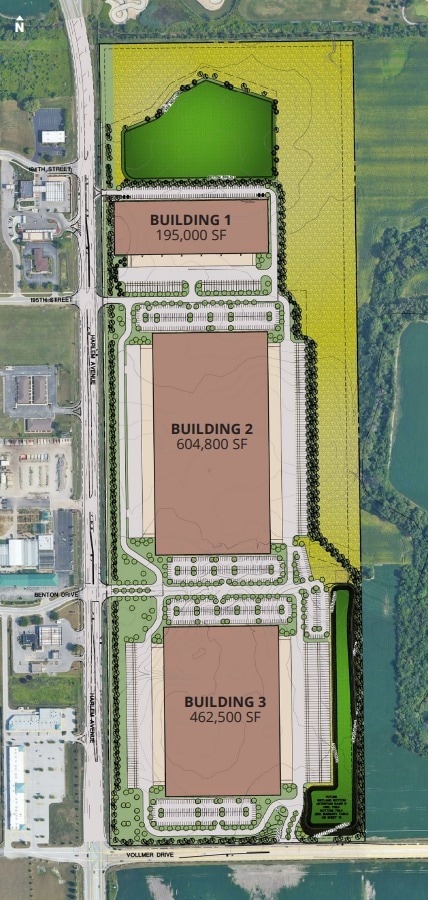
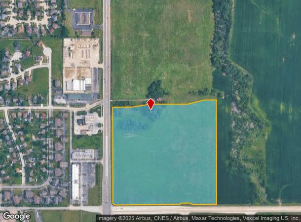
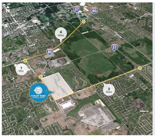
Property Record
19401 Harlem Ave, Tinley Park, IL 60477
This Property Is For Sale
NEARBY LISTINGS FOR SALE OR LEASE
Property Detail
19401 Harlem Ave
Chicago-Naperville-Elgin, IL-IN
Cook
31-07-103-001-0000
Illinois
Sfr
33.72 AC
AE
Near South Cook
17197C0216G
Chicago
2,445 SF
DEMOGRAPHICS near 19401 Harlem Ave
1 Mile
3 Mile
5 Mile
2024 Total Population
3,630
53,556
159,052
2029 Population
3,589
52,675
156,250
Pop Growth 2024-2029
(1.13%)
(1.65%)
(1.76%)
Average Age
42
42
42
2024 Total Households
1,283
19,825
58,663
HH Growth 2024-2029
(1.09%)
(1.89%)
(2.16%)
Median Household Inc
$123,632
$100,568
$92,734
Avg Household Size
2.80
2.60
2.60
2024 Avg HH Vehicles
2.00
2.00
2.00
Median Home Value
$274,667
$268,819
$262,799
Median Year Built
1996
1992
1985
Nearby Places
Map Layers
Map Styles
 Street
 Aerial
- Restaurants
- Banks
- Shops
- Fitness
- Groceries
PUBLIC TRANSPORTATION
COMMUTER RAIL
Tinley Park - 80Th Avenue Station (Rock Island District Line - Northeast Illinois Regional Commuter Railroad (Metra))
DRIVE
WALK
Distance
Tinley Park - 80Th Avenue Station (Rock Island District Line - Northeast Illinois Regional Commuter Railroad (Metra))
8 min
3.2 mi
Tinley Park Station (Rock Island District Line - Northeast Illinois Regional Commuter Railroad (Metra))
DRIVE
WALK
Distance
Tinley Park Station (Rock Island District Line - Northeast Illinois Regional Commuter Railroad (Metra))
7 min
3.6 mi
AIRPORT
Chicago Midway International
DRIVE
WALK
Distance
Chicago Midway International
34 min
20.7 mi
Freight Ports
Port Milwaukee
DRIVE
WALK
Distance
Port Milwaukee
139 min
111.3 mi
Nearby Properties
Address
Land Use
TOTAL SIZE
Lot Size
Zoning
Address
Land Use
TOTAL SIZE
Lot Size
Zoning
3,480,853 SF
Address
Land Use
TOTAL SIZE
Lot Size
Zoning
30.10 AC
Address
Land Use
TOTAL SIZE
Lot Size
Zoning
134,148 SF
5 AC
Address
Land Use
TOTAL SIZE
Lot Size
Zoning
Address
Land Use
TOTAL SIZE
Lot Size
Zoning
Address
Land Use
TOTAL SIZE
Lot Size
Zoning
304,608 SF
19.51 AC
Address
Land Use
TOTAL SIZE
Lot Size
Zoning
168,708 SF
14.74 AC
Address
Land Use
TOTAL SIZE
Lot Size
Zoning
911,379 SF
51.23 AC
Address
Land Use
TOTAL SIZE
Lot Size
Zoning
173,415 SF
14.97 AC
Address
Land Use
TOTAL SIZE
Lot Size
Zoning
238,068 SF
13.96 AC
Address
Land Use
TOTAL SIZE
Lot Size
Zoning
200,815 SF
10 AC
Address
Land Use
TOTAL SIZE
Lot Size
Zoning
4,168 SF
145.94 AC
Address
Land Use
TOTAL SIZE
Lot Size
Zoning
216,900 SF
10.11 AC
Address
Land Use
TOTAL SIZE
Lot Size
Zoning
280,313 SF
12.75 AC
Address
Land Use
TOTAL SIZE
Lot Size
Zoning
23.67 AC
Address
Land Use
TOTAL SIZE
Lot Size
Zoning
8.50 AC
Address
Land Use
TOTAL SIZE
Lot Size
Zoning
92,499 SF
5.29 AC
Address
Land Use
TOTAL SIZE
Lot Size
Zoning
113,474 SF
19.83 AC
Address
Land Use
TOTAL SIZE
Lot Size
Zoning
106,359 SF
8.25 AC
Address
Land Use
TOTAL SIZE
Lot Size
Zoning
40,000 SF
4.98 AC
Address
Land Use
TOTAL SIZE
Lot Size
Zoning
3,011 SF
125.12 AC
Address
Land Use
TOTAL SIZE
Lot Size
Zoning
92,166 SF
23.83 AC
Address
Land Use
TOTAL SIZE
Lot Size
Zoning
8.76 AC
Address
Land Use
TOTAL SIZE
Lot Size
Zoning
70,848 SF
10.18 AC
Address
Land Use
TOTAL SIZE
Lot Size
Zoning
55,435 SF
6.43 AC
Address
Land Use
TOTAL SIZE
Lot Size
Zoning
113,936 SF
6.96 AC
Address
Land Use
TOTAL SIZE
Lot Size
Zoning
16.24 AC
Address
Land Use
TOTAL SIZE
Lot Size
Zoning
125,016 SF
6.63 AC
Address
Land Use
TOTAL SIZE
Lot Size
Zoning
48,238 SF
5.17 AC
Address
Land Use
TOTAL SIZE
Lot Size
Zoning
297,330 SF
17.46 AC
The World's #1 Commercial Real Estate Marketplace
Connect with us
© 2026 CoStar Group
The information above has been obtained from sources believed reliable. While we do not doubt its accuracy we have not verified it and make no guarantee, warranty or representation about it. It is your responsibility to independently confirm its accuracy and completeness. Any projections, opinions, assumptions, or estimates used are for example only and do not represent the current or future performance of the property. The value of this transaction to you depends on tax and other factors which should be evaluated by your tax, financial, and legal advisors. You and your advisors should conduct a careful, independent investigation of the property to determine to your satisfaction the suitability of the property for your needs.