Property Record
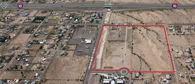
19605 W Mcdowell Rd, Buckeye, AZ 85396
Property Detail
19605 W Mcdowell Rd
Phoenix-Mesa-Chandler, AZ
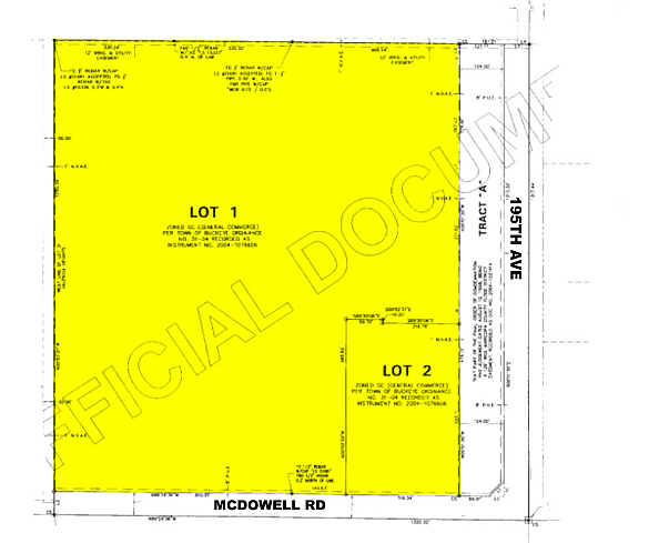
JRM NWC MCR 739-03
502-34-224
MARICOPA
Commercialnec
Arizona
C-C
a
C and X Area of minimal flood hazard, usually depicted on FIRMs as above the 500-year flood level.
3.48 AC
2025
West I-10
2025
Phoenix
050619
NEARBY LISTINGS FOR SALE OR LEASE
DEMOGRAPHICS near 19605 W Mcdowell Rd
1 mile
3 mile
5 mile
2025 Total Population
2,261
38,391
111,060
2030 Population
2,371
41,225
118,959
Pop Growth 2025-2030
+ 4.87%
+ 7.38%
+ 7.11%
Average Age
38
37
39
2025 Total Households
643
11,872
35,840
HH Growth 2025-2030
+ 4.98%
+ 7.52%
+ 7.32%
Median Household Inc
$117,045
$119,021
$113,821
Avg Household Size
3.40
3.20
3.00
2025 Avg HH Vehicles
3.00
2.00
2.00
Median Home Value
$596,690
$496,977
$499,177
Median Year Built
2004
2010
2010
Nearby Places
Map Layers
Map Styles
 Street
 Aerial
Layers
 Traffic
 Biking
Places
Listings with unknown addresses are not visible on the map
- Restaurants
- Banks
- Shops
- Fitness
- Groceries
PUBLIC TRANSPORTATION
AIRPORT
Phoenix Sky Harbor International
Drive
Walk
Distance
Phoenix Sky Harbor International
39 min
29.9 mi
SALE & LEASE HISTORY
LISTING DATE
SALE/LEASE

Sep 24, 2016
For Sale
Nearby Properties
Address
Land Use
TOTAL SIZE
Lot Size
Zoning
Address
Land Use
TOTAL SIZE
Lot Size
Zoning
551,831 SF
609.49 AC
AG
Address
Land Use
TOTAL SIZE
Lot Size
Zoning
196,353 SF
13.05 AC
C-C
Address
Land Use
TOTAL SIZE
Lot Size
Zoning
438,256 SF
48.59 AC
Address
Land Use
TOTAL SIZE
Lot Size
Zoning
9.44 AC
Address
Land Use
TOTAL SIZE
Lot Size
Zoning
721,156 SF
44.90 AC
PAD
Address
Land Use
TOTAL SIZE
Lot Size
Zoning
166,213 SF
29.60 AC
PAD
Address
Land Use
TOTAL SIZE
Lot Size
Zoning
231,044 SF
48.70 AC
Address
Land Use
TOTAL SIZE
Lot Size
Zoning
249,623 SF
50.12 AC
PAD
Address
Land Use
TOTAL SIZE
Lot Size
Zoning
185,251 SF
13.29 AC
PAD
Address
Land Use
TOTAL SIZE
Lot Size
Zoning
179,632 SF
16.64 AC
PR
Address
Land Use
TOTAL SIZE
Lot Size
Zoning
152,901 SF
22.52 AC
Address
Land Use
TOTAL SIZE
Lot Size
Zoning
Address
Land Use
TOTAL SIZE
Lot Size
Zoning
156,060 SF
12.04 AC
R-43
Address
Land Use
TOTAL SIZE
Lot Size
Zoning
82,692 SF
23.68 AC
Address
Land Use
TOTAL SIZE
Lot Size
Zoning
108,281 SF
11.95 AC
PC
Address
Land Use
TOTAL SIZE
Lot Size
Zoning
12,418 SF
54.25 AC
PC
Address
Land Use
TOTAL SIZE
Lot Size
Zoning
91,505 SF
16.57 AC
PAD
Address
Land Use
TOTAL SIZE
Lot Size
Zoning
80,531 SF
7.51 AC
PAD
Address
Land Use
TOTAL SIZE
Lot Size
Zoning
40,300 SF
19.53 AC
CC
Address
Land Use
TOTAL SIZE
Lot Size
Zoning
138.68 AC
Address
Land Use
TOTAL SIZE
Lot Size
Zoning
44,463 SF
79.72 AC
RR
Address
Land Use
TOTAL SIZE
Lot Size
Zoning
5,597 SF
164.45 AC
PR
Address
Land Use
TOTAL SIZE
Lot Size
Zoning
Address
Land Use
TOTAL SIZE
Lot Size
Zoning
64,720 SF
2.24 AC
PC
Address
Land Use
TOTAL SIZE
Lot Size
Zoning
34,356 SF
14.43 AC
CC
Address
Land Use
TOTAL SIZE
Lot Size
Zoning
38,713 SF
7.12 AC
PAD
Address
Land Use
TOTAL SIZE
Lot Size
Zoning
The World's #1 Commercial Real Estate Marketplace
Connect with us
© 2026 CoStar Group
The information above has been obtained from sources believed reliable. While we do not doubt its accuracy we have not verified it and make no guarantee, warranty or representation about it. It is your responsibility to independently confirm its accuracy and completeness. Any projections, opinions, assumptions, or estimates used are for example only and do not represent the current or future performance of the property. The value of this transaction to you depends on tax and other factors which should be evaluated by your tax, financial, and legal advisors. You and your advisors should conduct a careful, independent investigation of the property to determine to your satisfaction the suitability of the property for your needs.