Property Record
1961 Buford Hwy, Buford, GA 30518
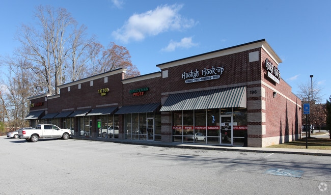

Property Detail
1961 Buford Hwy
7-269-086
LOT 1 AND PART OF LOT 2 HWY 23/CREEKSIDE DRIVE
Stripcommercialcenter
Gwinnett
C2
Georgia
B and X Area of moderate flood hazard, usually the area between the limits of the 100-year and 500-year floods.
269
2025
1.20 AC
2025
Suwanee/Buford
050115
Atlanta
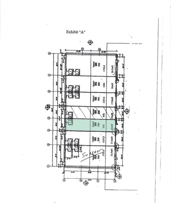
9,240 SF
Atlanta-Sandy Springs-Roswell, GA
NEARBY LISTINGS FOR SALE OR LEASE
DEMOGRAPHICS near 1961 Buford Hwy
1 mile
3 mile
5 mile
2024 Total Population
5,606
50,626
132,367
2029 Population
5,951
53,746
140,098
Pop Growth 2024-2029
+ 6.15%
+ 6.16%
+ 5.84%
Average Age
37
37
38
2024 Total Households
1,918
16,735
44,087
HH Growth 2024-2029
+ 6.31%
+ 6.28%
+ 6.03%
Median Household Inc
$64,100
$83,651
$94,651
Avg Household Size
2.90
3.00
3.00
2024 Avg HH Vehicles
2.00
2.00
2.00
Median Home Value
$490,853
$441,195
$448,013
Median Year Built
1992
2002
2002
Nearby Places
Map Layers
Map Styles
 Street
 Aerial
Transit
 Traffic
 Biking
Places
Listings with unknown addresses are not visible on the map
- Restaurants
- Banks
- Shops
- Fitness
- Groceries
SALE & LEASE HISTORY
LISTING DATE
SALE/LEASE

Feb 03, 2017
For Lease
Dec 15, 2016
For Lease
Nearby Properties
Address
Land Use
TOTAL SIZE
Lot Size
Zoning
Address
Land Use
TOTAL SIZE
Lot Size
Zoning
1,435,842 SF
83.47 AC
C2
Address
Land Use
TOTAL SIZE
Lot Size
Zoning
629,478 SF
1.54 AC
BG
Address
Land Use
TOTAL SIZE
Lot Size
Zoning
488,895 SF
7.50 AC
OI
Address
Land Use
TOTAL SIZE
Lot Size
Zoning
330,562 SF
29.62 AC
RM13
Address
Land Use
TOTAL SIZE
Lot Size
Zoning
286,520 SF
21.60 AC
P
Address
Land Use
TOTAL SIZE
Lot Size
Zoning
368,594 SF
2 AC
Address
Land Use
TOTAL SIZE
Lot Size
Zoning
384,000 SF
23.08 AC
BG
Address
Land Use
TOTAL SIZE
Lot Size
Zoning
431,273 SF
11.68 AC
BG
Address
Land Use
TOTAL SIZE
Lot Size
Zoning
521,231 SF
46.16 AC
HM1
Address
Land Use
TOTAL SIZE
Lot Size
Zoning
313,869 SF
12.19 AC
RM24
Address
Land Use
TOTAL SIZE
Lot Size
Zoning
461,700 SF
43.77 AC
C2
Address
Land Use
TOTAL SIZE
Lot Size
Zoning
367,756 SF
12.04 AC
RM
Address
Land Use
TOTAL SIZE
Lot Size
Zoning
323,877 SF
29.14 AC
C2
Address
Land Use
TOTAL SIZE
Lot Size
Zoning
144,000 SF
21.13 AC
RM
Address
Land Use
TOTAL SIZE
Lot Size
Zoning
204,436 SF
16.28 AC
BG2
Address
Land Use
TOTAL SIZE
Lot Size
Zoning
496,608 SF
29.68 AC
C2
Address
Land Use
TOTAL SIZE
Lot Size
Zoning
379,104 SF
20 AC
OI
Address
Land Use
TOTAL SIZE
Lot Size
Zoning
652,710 SF
40.90 AC
M1
Address
Land Use
TOTAL SIZE
Lot Size
Zoning
440,904 SF
37.84 AC
M1
Address
Land Use
TOTAL SIZE
Lot Size
Zoning
264,600 SF
10.27 AC
M1
Address
Land Use
TOTAL SIZE
Lot Size
Zoning
150,591 SF
24.39 AC
P
Address
Land Use
TOTAL SIZE
Lot Size
Zoning
641,180 SF
57.04 AC
M1
Address
Land Use
TOTAL SIZE
Lot Size
Zoning
353,241 SF
33.16 AC
C2
Address
Land Use
TOTAL SIZE
Lot Size
Zoning
875,180 SF
58.69 AC
C1
Address
Land Use
TOTAL SIZE
Lot Size
Zoning
573,750 SF
43.94 AC
C1
Address
Land Use
TOTAL SIZE
Lot Size
Zoning
3,232 SF
66.63 AC
OI
Address
Land Use
TOTAL SIZE
Lot Size
Zoning
274,018 SF
25.57 AC
M1
Address
Land Use
TOTAL SIZE
Lot Size
Zoning
544,900 SF
46.95 AC
M1
Address
Land Use
TOTAL SIZE
Lot Size
Zoning
72,304 SF
83.10 AC
R100
Address
Land Use
TOTAL SIZE
Lot Size
Zoning
119,188 SF
5.28 AC
BG
The World's #1 Commercial Real Estate Marketplace
Connect with us
© 2026 CoStar Group
The information above has been obtained from sources believed reliable. While we do not doubt its accuracy we have not verified it and make no guarantee, warranty or representation about it. It is your responsibility to independently confirm its accuracy and completeness. Any projections, opinions, assumptions, or estimates used are for example only and do not represent the current or future performance of the property. The value of this transaction to you depends on tax and other factors which should be evaluated by your tax, financial, and legal advisors. You and your advisors should conduct a careful, independent investigation of the property to determine to your satisfaction the suitability of the property for your needs.