Property Record
1961 State Highway 5S, Amsterdam, NY 12010


NEARBY LISTINGS FOR SALE OR LEASE
-
-
View all Amsterdam listings for sale on LoopNet.com
Property Detail
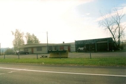
1961 State Highway 5S
272600-054-000-0001-009-001-0000
W DEED BK445 PG663
Storebuilding
Montgomery
X
New York
36057C0195E
9.001
2025
7.90 AC
2024
Montgomery County
072800
Albany/Schenectady/Troy
10,000 SF
Amsterdam, NY
DEMOGRAPHICS near 1961 State Highway 5S
1 Mile
3 Mile
5 Mile
2024 Total Population
184
6,403
24,736
2029 Population
182
6,328
24,687
Pop Growth 2024-2029
(1.09%)
(1.17%)
(0.20%)
Average Age
44
43
41
2024 Total Households
72
2,720
10,232
HH Growth 2024-2029
0.00%
(1.18%)
(0.18%)
Median Household Inc
$85,714
$64,314
$48,700
Avg Household Size
2.50
2.30
2.30
2024 Avg HH Vehicles
2.00
2.00
1.00
Median Home Value
$170,370
$139,253
$127,054
Median Year Built
1947
1947
1948
Nearby Places
Map Layers
Map Styles
 Street
 Aerial
- Restaurants
- Banks
- Shops
- Fitness
- Groceries
PUBLIC TRANSPORTATION
COMMUTER RAIL
DRIVE
WALK
Distance
11 min
5.7 mi
DRIVE
WALK
Distance
11 min
5.7 mi
AIRPORT
Albany International
DRIVE
WALK
Distance
Albany International
48 min
31.3 mi
Nearby Properties
Address
Land Use
TOTAL SIZE
Lot Size
Zoning
Address
Land Use
TOTAL SIZE
Lot Size
Zoning
8,924 SF
241.40 AC
Address
Land Use
TOTAL SIZE
Lot Size
Zoning
568,407 SF
95.30 AC
Address
Land Use
TOTAL SIZE
Lot Size
Zoning
756,760 SF
102.40 AC
Address
Land Use
TOTAL SIZE
Lot Size
Zoning
226,614 SF
4.80 AC
05 - COMME
Address
Land Use
TOTAL SIZE
Lot Size
Zoning
126,707 SF
39.10 AC
Address
Land Use
TOTAL SIZE
Lot Size
Zoning
6.90 AC
Address
Land Use
TOTAL SIZE
Lot Size
Zoning
69,900 SF
24 AC
Address
Land Use
TOTAL SIZE
Lot Size
Zoning
97,304 SF
41.90 AC
Address
Land Use
TOTAL SIZE
Lot Size
Zoning
101,736 SF
92.40 AC
Address
Land Use
TOTAL SIZE
Lot Size
Zoning
383.63 AC
CONF
Address
Land Use
TOTAL SIZE
Lot Size
Zoning
226,614 SF
1 AC
07 - MIXED
Address
Land Use
TOTAL SIZE
Lot Size
Zoning
38,350 SF
6.50 AC
06 - INDUS
Address
Land Use
TOTAL SIZE
Lot Size
Zoning
29,588 SF
2.40 AC
07 - MIXED
Address
Land Use
TOTAL SIZE
Lot Size
Zoning
53,949 SF
13.10 AC
Address
Land Use
TOTAL SIZE
Lot Size
Zoning
23,724 SF
6.80 AC
05 - COMME
Address
Land Use
TOTAL SIZE
Lot Size
Zoning
1,593 SF
137.40 AC
Address
Land Use
TOTAL SIZE
Lot Size
Zoning
36.90 AC
Address
Land Use
TOTAL SIZE
Lot Size
Zoning
27.80 AC
Address
Land Use
TOTAL SIZE
Lot Size
Zoning
16,392 SF
2.20 AC
05 - COMME
Address
Land Use
TOTAL SIZE
Lot Size
Zoning
26,677 SF
1.40 AC
05 - COMME
Address
Land Use
TOTAL SIZE
Lot Size
Zoning
0.11 AC
Address
Land Use
TOTAL SIZE
Lot Size
Zoning
16.70 AC
Address
Land Use
TOTAL SIZE
Lot Size
Zoning
25,768 SF
2 AC
05 - COMME
Address
Land Use
TOTAL SIZE
Lot Size
Zoning
8,000 SF
6.40 AC
Address
Land Use
TOTAL SIZE
Lot Size
Zoning
42,380 SF
4.10 AC
05 - COMME
Address
Land Use
TOTAL SIZE
Lot Size
Zoning
21,910 SF
5.30 AC
Address
Land Use
TOTAL SIZE
Lot Size
Zoning
15,728 SF
66.70 AC
Address
Land Use
TOTAL SIZE
Lot Size
Zoning
12,755 SF
10.50 AC
Address
Land Use
TOTAL SIZE
Lot Size
Zoning
22,539 SF
1.90 AC
03 - MULTI
Address
Land Use
TOTAL SIZE
Lot Size
Zoning
22,000 SF
10.14 AC
05 - COMME
The World's #1 Commercial Real Estate Marketplace
Connect with us
© 2026 CoStar Group
The information above has been obtained from sources believed reliable. While we do not doubt its accuracy we have not verified it and make no guarantee, warranty or representation about it. It is your responsibility to independently confirm its accuracy and completeness. Any projections, opinions, assumptions, or estimates used are for example only and do not represent the current or future performance of the property. The value of this transaction to you depends on tax and other factors which should be evaluated by your tax, financial, and legal advisors. You and your advisors should conduct a careful, independent investigation of the property to determine to your satisfaction the suitability of the property for your needs.