Property Record
19610 Cantrell Rd, Little Rock, AR 72223
NEARBY LISTINGS FOR SALE OR LEASE
-
-
View all Little Rock listings for lease on LoopNet.com
Property Detail
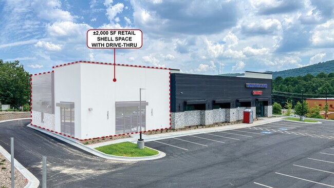
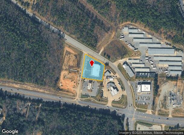
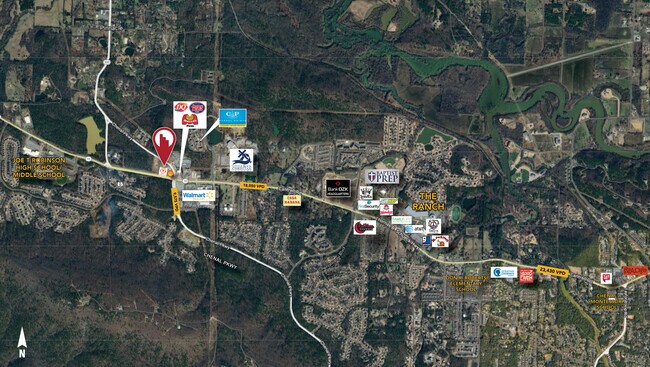
19610 Cantrell Rd
Little Rock/N Little Rock
20100 Highway 10 Subdivision
Little Rock-North Little Rock-Conway, AR
LOT 9E, 20100 HIGHWAY 10 SUBDIVISION
53L-015-08-002-00
Pulaski
Storebuilding
Arkansas
2025
9e
2025
1.06 AC
004205
West
15,861 SF
DEMOGRAPHICS near 19610 Cantrell Rd
1 Mile
3 Mile
5 Mile
2024 Total Population
2,475
14,060
39,763
2029 Population
2,499
14,145
39,578
Pop Growth 2024-2029
+ 0.97%
+ 0.60%
(0.47%)
Average Age
41
43
42
2024 Total Households
1,062
5,646
16,284
HH Growth 2024-2029
+ 0.56%
+ 0.46%
(0.55%)
Median Household Inc
$106,833
$139,176
$113,888
Avg Household Size
2.30
2.40
2.40
2024 Avg HH Vehicles
2.00
2.00
2.00
Median Home Value
$361,396
$395,297
$354,302
Median Year Built
2007
2004
1997
Nearby Places
Map Layers
Map Styles
 Street
 Aerial
- Restaurants
- Banks
- Shops
- Fitness
- Groceries
PUBLIC TRANSPORTATION
AIRPORT
Bill and Hillary Clinton Ntl/Adams Field
DRIVE
WALK
Distance
Bill and Hillary Clinton Ntl/Adams Field
31 min
19.9 mi
SALE & LEASE HISTORY
LISTING DATE
SALE/LEASE

Jul 31, 2024
For Lease
Nearby Properties
Address
Land Use
TOTAL SIZE
Lot Size
Zoning
Address
Land Use
TOTAL SIZE
Lot Size
Zoning
361,360 SF
20.01 AC
Address
Land Use
TOTAL SIZE
Lot Size
Zoning
126,536 SF
25.98 AC
Address
Land Use
TOTAL SIZE
Lot Size
Zoning
267,343 SF
52.19 AC
Address
Land Use
TOTAL SIZE
Lot Size
Zoning
82,176 SF
14.83 AC
Address
Land Use
TOTAL SIZE
Lot Size
Zoning
125,107 SF
22.09 AC
Address
Land Use
TOTAL SIZE
Lot Size
Zoning
58,828 SF
15.22 AC
Address
Land Use
TOTAL SIZE
Lot Size
Zoning
115,062 SF
10.04 AC
Address
Land Use
TOTAL SIZE
Lot Size
Zoning
160,068 SF
18.91 AC
Address
Land Use
TOTAL SIZE
Lot Size
Zoning
217,088 SF
26.89 AC
Address
Land Use
TOTAL SIZE
Lot Size
Zoning
102,990 SF
10.43 AC
Address
Land Use
TOTAL SIZE
Lot Size
Zoning
42,686 SF
22.11 AC
Address
Land Use
TOTAL SIZE
Lot Size
Zoning
103,169 SF
8.32 AC
Address
Land Use
TOTAL SIZE
Lot Size
Zoning
206,671 SF
26.16 AC
Address
Land Use
TOTAL SIZE
Lot Size
Zoning
91,822 SF
14 AC
Address
Land Use
TOTAL SIZE
Lot Size
Zoning
173,120 SF
67.23 AC
Address
Land Use
TOTAL SIZE
Lot Size
Zoning
99,581 SF
8.11 AC
Address
Land Use
TOTAL SIZE
Lot Size
Zoning
58,854 SF
7.11 AC
Address
Land Use
TOTAL SIZE
Lot Size
Zoning
38,617 SF
4.62 AC
Address
Land Use
TOTAL SIZE
Lot Size
Zoning
37,229 SF
4.06 AC
Address
Land Use
TOTAL SIZE
Lot Size
Zoning
12,469 SF
10 AC
Address
Land Use
TOTAL SIZE
Lot Size
Zoning
21.56 AC
Address
Land Use
TOTAL SIZE
Lot Size
Zoning
24,997 SF
9.78 AC
Address
Land Use
TOTAL SIZE
Lot Size
Zoning
58,825 SF
7.34 AC
Address
Land Use
TOTAL SIZE
Lot Size
Zoning
21,639 SF
6.76 AC
Address
Land Use
TOTAL SIZE
Lot Size
Zoning
30,510 SF
18.76 AC
Address
Land Use
TOTAL SIZE
Lot Size
Zoning
56,054 SF
20.93 AC
Address
Land Use
TOTAL SIZE
Lot Size
Zoning
29,097 SF
98.42 AC
Address
Land Use
TOTAL SIZE
Lot Size
Zoning
42,015 SF
18.33 AC
Address
Land Use
TOTAL SIZE
Lot Size
Zoning
6,699 SF
7.53 AC
Address
Land Use
TOTAL SIZE
Lot Size
Zoning
73,873 SF
7.26 AC
The World's #1 Commercial Real Estate Marketplace
Connect with us
© 2025 CoStar Group
The information above has been obtained from sources believed reliable. While we do not doubt its accuracy we have not verified it and make no guarantee, warranty or representation about it. It is your responsibility to independently confirm its accuracy and completeness. Any projections, opinions, assumptions, or estimates used are for example only and do not represent the current or future performance of the property. The value of this transaction to you depends on tax and other factors which should be evaluated by your tax, financial, and legal advisors. You and your advisors should conduct a careful, independent investigation of the property to determine to your satisfaction the suitability of the property for your needs.