Property Record
1962 Highway 160 W, Fort Mill, SC 29708
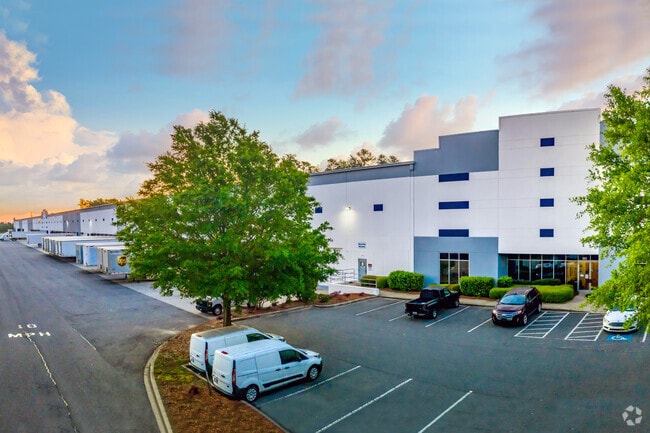


Property Detail
1962 Highway 160 W
6530000022
HWY 160 (35.631AC) ID 36 MM
Commercialnec
York
ID
South Carolina
AE The base floodplain where base flood elevations are provided. AE Zones are now used on new format FIRMs instead of A1-A30 Zones.
35.63 AC
2025
York County
2025
Charlotte
061011
Charlotte-Concord-Gastonia, NC-SC
280,000 SF
NEARBY LISTINGS FOR SALE OR LEASE
-
-
View all Fort Mill listings for lease on LoopNet.com
DEMOGRAPHICS near 1962 Highway 160 W
1 mile
3 mile
5 mile
2025 Total Population
6,980
52,212
132,818
2030 Population
7,485
55,551
142,236
Pop Growth 2025-2030
+ 7.23%
+ 6.40%
+ 7.09%
Average Age
38
39
39
2025 Total Households
2,606
19,369
50,203
HH Growth 2025-2030
+ 7.18%
+ 6.37%
+ 7.07%
Median Household Inc
$110,462
$118,224
$112,222
Avg Household Size
2.70
2.70
2.60
2025 Avg HH Vehicles
2.00
2.00
2.00
Median Home Value
$539,352
$498,287
$472,429
Median Year Built
2010
2007
2006
Nearby Places
Map Layers
Map Styles
 Street
 Aerial
Layers
 Traffic
 Biking
Places
Listings with unknown addresses are not visible on the map
- Restaurants
- Banks
- Shops
- Fitness
- Groceries
PUBLIC TRANSPORTATION
AIRPORT
Charlotte/Douglas International
Drive
Walk
Distance
Charlotte/Douglas International
28 min
14.6 mi
Concord-Padgett Regional
Drive
Walk
Distance
Concord-Padgett Regional
47 min
33.4 mi
Freight Ports
North Charleston Terminal
Drive
Walk
Distance
North Charleston Terminal
207 min
184.4 mi
SALE & LEASE HISTORY
LISTING DATE
SALE/LEASE

Jan 15, 2019
For Lease
Feb 22, 2021
For Lease
Apr 03, 2019
For Lease
Nearby Properties
Address
Land Use
TOTAL SIZE
Lot Size
Zoning
Address
Land Use
TOTAL SIZE
Lot Size
Zoning
151,844 SF
11.65 AC
Address
Land Use
TOTAL SIZE
Lot Size
Zoning
401.79 AC
Address
Land Use
TOTAL SIZE
Lot Size
Zoning
335.85 AC
AGC
Address
Land Use
TOTAL SIZE
Lot Size
Zoning
790,440 SF
53.19 AC
Address
Land Use
TOTAL SIZE
Lot Size
Zoning
178,585 SF
17.44 AC
Address
Land Use
TOTAL SIZE
Lot Size
Zoning
2,476 SF
88.14 AC
Address
Land Use
TOTAL SIZE
Lot Size
Zoning
162.78 AC
RCI
Address
Land Use
TOTAL SIZE
Lot Size
Zoning
64,113 SF
6.69 AC
Address
Land Use
TOTAL SIZE
Lot Size
Zoning
197,864 SF
39.37 AC
Address
Land Use
TOTAL SIZE
Lot Size
Zoning
79,600 SF
9.58 AC
Address
Land Use
TOTAL SIZE
Lot Size
Zoning
11,056 SF
1.89 AC
RDI
Address
Land Use
TOTAL SIZE
Lot Size
Zoning
26,733 SF
34.66 AC
PD
Address
Land Use
TOTAL SIZE
Lot Size
Zoning
45.75 AC
RDI
Address
Land Use
TOTAL SIZE
Lot Size
Zoning
38,954 SF
21.23 AC
BDIII
Address
Land Use
TOTAL SIZE
Lot Size
Zoning
81,700 SF
43.75 AC
Address
Land Use
TOTAL SIZE
Lot Size
Zoning
2,238 SF
38.21 AC
RCI
Address
Land Use
TOTAL SIZE
Lot Size
Zoning
25,554 SF
14.18 AC
PD
Address
Land Use
TOTAL SIZE
Lot Size
Zoning
33,312 SF
14.71 AC
Address
Land Use
TOTAL SIZE
Lot Size
Zoning
131,716 SF
13.89 AC
Address
Land Use
TOTAL SIZE
Lot Size
Zoning
17,304 SF
3.30 AC
BDII
Address
Land Use
TOTAL SIZE
Lot Size
Zoning
155,948 SF
17.02 AC
UD
Address
Land Use
TOTAL SIZE
Lot Size
Zoning
48,912 SF
14.66 AC
Address
Land Use
TOTAL SIZE
Lot Size
Zoning
27,436 SF
16.85 AC
BDI
Address
Land Use
TOTAL SIZE
Lot Size
Zoning
250,903 SF
16.52 AC
BDII
Address
Land Use
TOTAL SIZE
Lot Size
Zoning
32,564 SF
13.44 AC
PD
Address
Land Use
TOTAL SIZE
Lot Size
Zoning
10.57 AC
Address
Land Use
TOTAL SIZE
Lot Size
Zoning
39,312 SF
13.11 AC
Address
Land Use
TOTAL SIZE
Lot Size
Zoning
24,200 SF
2.18 AC
Address
Land Use
TOTAL SIZE
Lot Size
Zoning
4,058 SF
28.55 AC
AGC
The World's #1 Commercial Real Estate Marketplace
Connect with us
© 2026 CoStar Group
The information above has been obtained from sources believed reliable. While we do not doubt its accuracy we have not verified it and make no guarantee, warranty or representation about it. It is your responsibility to independently confirm its accuracy and completeness. Any projections, opinions, assumptions, or estimates used are for example only and do not represent the current or future performance of the property. The value of this transaction to you depends on tax and other factors which should be evaluated by your tax, financial, and legal advisors. You and your advisors should conduct a careful, independent investigation of the property to determine to your satisfaction the suitability of the property for your needs.