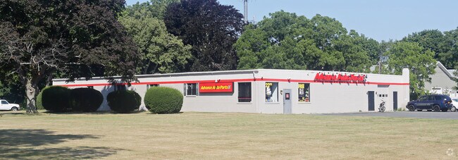
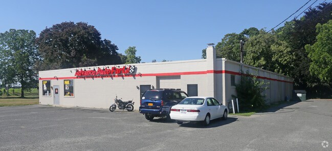
Property Record
19625 Main Rd, Mattituck, NY 11952
NEARBY LISTINGS FOR SALE OR LEASE
Property Detail
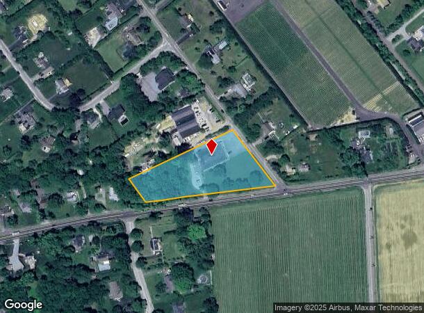
19625 Main Rd
Nassau County-Suffolk County, NY
William J Baxter Jr
1000-108-00-04-00-011-002
BOOK PAGE BILL 013332
Commercialnec
Suffolk
X
New York
36103C0482H
11
2024
2.31 AC
2024
Eastern Suffolk
170004
Long Island (New York)
DEMOGRAPHICS near 19625 Main Rd
1 mile
3 mile
5 mile
2024 Total Population
1,403
9,619
13,599
2029 Population
1,415
9,792
13,866
Pop Growth 2024-2029
+ 0.86%
+ 1.80%
+ 1.96%
Average Age
46
47
47
2024 Total Households
555
3,843
5,510
HH Growth 2024-2029
+ 0.72%
+ 1.59%
+ 1.83%
Median Household Inc
$100,212
$100,624
$101,453
Avg Household Size
2.40
2.40
2.40
2024 Avg HH Vehicles
2.00
2.00
2.00
Median Home Value
$724,026
$721,124
$739,932
Median Year Built
1971
1974
1975
Nearby Places
Map Layers
Map Styles
 Street
 Aerial
Transit
 Traffic
 Biking
Places
Listings with unknown addresses are not visible on the map
- Restaurants
- Banks
- Shops
- Fitness
- Groceries
PUBLIC TRANSPORTATION
COMMUTER RAIL
Mattituck Station (Greenport Branch - Long Island Rail Road)
Drive
Walk
Distance
Mattituck Station (Greenport Branch - Long Island Rail Road)
3 min
1.6 mi
Southold Station (Greenport Branch - Long Island Rail Road)
Drive
Walk
Distance
Southold Station (Greenport Branch - Long Island Rail Road)
12 min
7.8 mi
Freight Ports
Port of New Haven
Drive
Walk
Distance
Port of New Haven
162 min
68.6 mi
Nearby Properties
Address
Land Use
TOTAL SIZE
Lot Size
Zoning
Address
Land Use
TOTAL SIZE
Lot Size
Zoning
1,392 SF
0.27 AC
R20
Address
Land Use
TOTAL SIZE
Lot Size
Zoning
30.40 AC
R-80
Address
Land Use
TOTAL SIZE
Lot Size
Zoning
26.14 AC
R-80
Address
Land Use
TOTAL SIZE
Lot Size
Zoning
638 SF
0.01 AC
R40
Address
Land Use
TOTAL SIZE
Lot Size
Zoning
0.79 AC
VILLA
Address
Land Use
TOTAL SIZE
Lot Size
Zoning
8.75 AC
B
Address
Land Use
TOTAL SIZE
Lot Size
Zoning
Address
Land Use
TOTAL SIZE
Lot Size
Zoning
17.40 AC
RR
Address
Land Use
TOTAL SIZE
Lot Size
Zoning
45.33 AC
R-80
Address
Land Use
TOTAL SIZE
Lot Size
Zoning
5.60 AC
RO R-40
Address
Land Use
TOTAL SIZE
Lot Size
Zoning
4.91 AC
B
Address
Land Use
TOTAL SIZE
Lot Size
Zoning
1.34 AC
HB
Address
Land Use
TOTAL SIZE
Lot Size
Zoning
0.47 AC
BUS1
Address
Land Use
TOTAL SIZE
Lot Size
Zoning
Address
Land Use
TOTAL SIZE
Lot Size
Zoning
32.26 AC
R-80 R-40
Address
Land Use
TOTAL SIZE
Lot Size
Zoning
7.20 AC
AC
Address
Land Use
TOTAL SIZE
Lot Size
Zoning
154.70 AC
AC R-40
Address
Land Use
TOTAL SIZE
Lot Size
Zoning
6 AC
R-40
Address
Land Use
TOTAL SIZE
Lot Size
Zoning
59.94 AC
LI
Address
Land Use
TOTAL SIZE
Lot Size
Zoning
8.50 AC
MII
Address
Land Use
TOTAL SIZE
Lot Size
Zoning
10.70 AC
R-40
Address
Land Use
TOTAL SIZE
Lot Size
Zoning
32.60 AC
MII R-80
Address
Land Use
TOTAL SIZE
Lot Size
Zoning
3 AC
R-40
Address
Land Use
TOTAL SIZE
Lot Size
Zoning
Address
Land Use
TOTAL SIZE
Lot Size
Zoning
5.65 AC
LI
Address
Land Use
TOTAL SIZE
Lot Size
Zoning
99.76 AC
AC R-40
Address
Land Use
TOTAL SIZE
Lot Size
Zoning
13.37 AC
AC
Address
Land Use
TOTAL SIZE
Lot Size
Zoning
1.50 AC
RO R-40
Address
Land Use
TOTAL SIZE
Lot Size
Zoning
17.10 AC
AC
Address
Land Use
TOTAL SIZE
Lot Size
Zoning
9 AC
MII
The World's #1 Commercial Real Estate Marketplace
Connect with us
© 2026 CoStar Group
The information above has been obtained from sources believed reliable. While we do not doubt its accuracy we have not verified it and make no guarantee, warranty or representation about it. It is your responsibility to independently confirm its accuracy and completeness. Any projections, opinions, assumptions, or estimates used are for example only and do not represent the current or future performance of the property. The value of this transaction to you depends on tax and other factors which should be evaluated by your tax, financial, and legal advisors. You and your advisors should conduct a careful, independent investigation of the property to determine to your satisfaction the suitability of the property for your needs.