Property Record
1963 Fowl Rd, Elyria, OH 44035
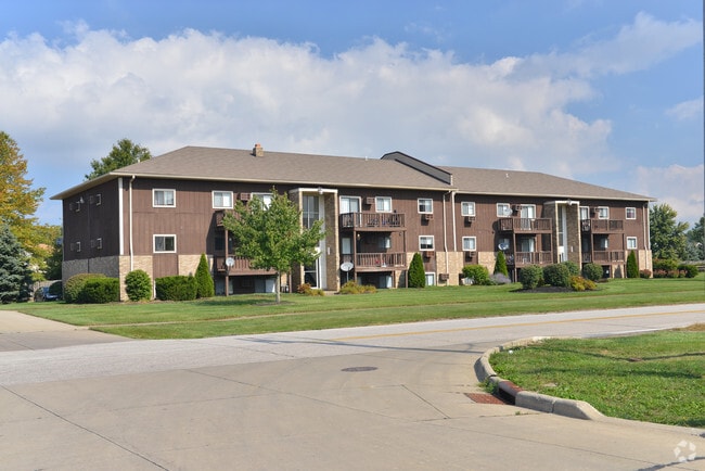

Property Detail
1963 Fowl Rd
Cleveland-Elyria, OH
WASHINGTON VILLAGE SUB ***** SEE NOTES *****
05-00-088-000-023
LORAIN
Apartment
Ohio
B and X Area of moderate flood hazard, usually the area between the limits of the 100-year and 500-year floods.
blk d
2024
0.75 AC
2024
Outlying Lorain County
070902
Cleveland
10,560 SF
NEARBY LISTINGS FOR SALE OR LEASE
-
-
View all Elyria listings for sale on LoopNet.com
DEMOGRAPHICS near 1963 Fowl Rd
1 mile
3 mile
5 mile
2025 Total Population
3,942
23,882
90,408
2030 Population
4,106
24,511
92,394
Pop Growth 2025-2030
+ 4.16%
+ 2.63%
+ 2.20%
Average Age
44
42
42
2025 Total Households
1,989
10,176
38,718
HH Growth 2025-2030
+ 4.12%
+ 2.77%
+ 2.26%
Median Household Inc
$50,750
$49,704
$63,235
Avg Household Size
1.90
2.20
2.30
2025 Avg HH Vehicles
2.00
2.00
2.00
Median Home Value
$139,380
$149,062
$170,448
Median Year Built
1983
1964
1966
Nearby Places
Map Layers
Map Styles
 Street
 Aerial
Layers
 Traffic
 Biking
Places
Listings with unknown addresses are not visible on the map
- Restaurants
- Banks
- Shops
- Fitness
- Groceries
PUBLIC TRANSPORTATION
COMMUTER RAIL
Elyria Amtrak (Capitol Limited - Amtrak, Lake Shore Limited - Amtrak)
Drive
Walk
Distance
Elyria Amtrak (Capitol Limited - Amtrak, Lake Shore Limited - Amtrak)
9 min
3.9 mi
AIRPORT
Cleveland-Hopkins International
Drive
Walk
Distance
Cleveland-Hopkins International
33 min
21.0 mi
Freight Ports
Port of Toledo
Drive
Walk
Distance
Port of Toledo
108 min
87.7 mi
Nearby Properties
Address
Land Use
TOTAL SIZE
Lot Size
Zoning
Address
Land Use
TOTAL SIZE
Lot Size
Zoning
351,623 SF
3.13 AC
Address
Land Use
TOTAL SIZE
Lot Size
Zoning
199,200 SF
1.77 AC
Address
Land Use
TOTAL SIZE
Lot Size
Zoning
61,570 SF
0.20 AC
Address
Land Use
TOTAL SIZE
Lot Size
Zoning
112,888 SF
8.92 AC
Address
Land Use
TOTAL SIZE
Lot Size
Zoning
32,784 SF
0.25 AC
Address
Land Use
TOTAL SIZE
Lot Size
Zoning
158,510 SF
6.01 AC
Address
Land Use
TOTAL SIZE
Lot Size
Zoning
194,787 SF
19.04 AC
Address
Land Use
TOTAL SIZE
Lot Size
Zoning
76,610 SF
2.49 AC
Address
Land Use
TOTAL SIZE
Lot Size
Zoning
52,685 SF
13.19 AC
Address
Land Use
TOTAL SIZE
Lot Size
Zoning
42,095 SF
2.34 AC
Address
Land Use
TOTAL SIZE
Lot Size
Zoning
47,277 SF
54.68 AC
Address
Land Use
TOTAL SIZE
Lot Size
Zoning
56,244 SF
0.17 AC
Address
Land Use
TOTAL SIZE
Lot Size
Zoning
62.37 AC
Address
Land Use
TOTAL SIZE
Lot Size
Zoning
27,756 SF
2.61 AC
Address
Land Use
TOTAL SIZE
Lot Size
Zoning
28,524 SF
5.90 AC
Address
Land Use
TOTAL SIZE
Lot Size
Zoning
423,598 SF
160.58 AC
Address
Land Use
TOTAL SIZE
Lot Size
Zoning
4,392 SF
0.82 AC
Address
Land Use
TOTAL SIZE
Lot Size
Zoning
182,568 SF
43.21 AC
Address
Land Use
TOTAL SIZE
Lot Size
Zoning
191,480 SF
7.10 AC
Address
Land Use
TOTAL SIZE
Lot Size
Zoning
110,868 SF
7.52 AC
Address
Land Use
TOTAL SIZE
Lot Size
Zoning
15,430 SF
0.42 AC
Address
Land Use
TOTAL SIZE
Lot Size
Zoning
23,568 SF
3.04 AC
Address
Land Use
TOTAL SIZE
Lot Size
Zoning
49,570 SF
7.27 AC
Address
Land Use
TOTAL SIZE
Lot Size
Zoning
43,204 SF
3.91 AC
Address
Land Use
TOTAL SIZE
Lot Size
Zoning
73,080 SF
12.79 AC
Address
Land Use
TOTAL SIZE
Lot Size
Zoning
8,324 SF
0.21 AC
Address
Land Use
TOTAL SIZE
Lot Size
Zoning
61.17 AC
Address
Land Use
TOTAL SIZE
Lot Size
Zoning
38,136 SF
0.75 AC
Address
Land Use
TOTAL SIZE
Lot Size
Zoning
8,904 SF
1.48 AC
Address
Land Use
TOTAL SIZE
Lot Size
Zoning
9,291 SF
2 AC
The World's #1 Commercial Real Estate Marketplace
Connect with us
© 2026 CoStar Group
The information above has been obtained from sources believed reliable. While we do not doubt its accuracy we have not verified it and make no guarantee, warranty or representation about it. It is your responsibility to independently confirm its accuracy and completeness. Any projections, opinions, assumptions, or estimates used are for example only and do not represent the current or future performance of the property. The value of this transaction to you depends on tax and other factors which should be evaluated by your tax, financial, and legal advisors. You and your advisors should conduct a careful, independent investigation of the property to determine to your satisfaction the suitability of the property for your needs.