Property Record
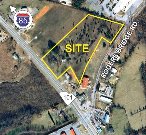
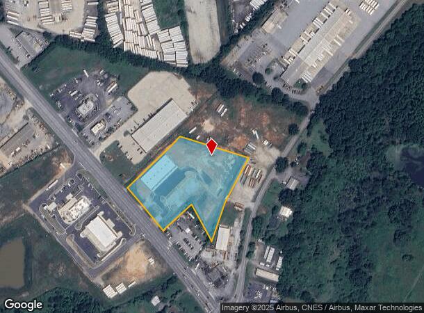
1963 Highway 101 S, Greer, SC 29651

NEARBY LISTINGS FOR SALE OR LEASE
Property Detail
1963 Highway 101 S
5-29-00-129.00
Survey For James Leonard
Commercialnec
N SIDE HWY 101 & W OF ROGERS BRIDGE RD HWY R/W TAKEN PB 179-480PB 184-366
X
Spartanburg
45083C0219D
South Carolina
2024
3.33 AC
2025
Rt 101 Corridor
023202
Greenville/Spartanburg
2,438 SF
Spartanburg, SC
DEMOGRAPHICS near 1963 Highway 101 S
1 mile
3 mile
5 mile
2024 Total Population
978
13,647
49,308
2029 Population
1,130
15,673
56,412
Pop Growth 2024-2029
+ 15.54%
+ 14.85%
+ 14.41%
Average Age
39
38
38
2024 Total Households
357
4,903
18,295
HH Growth 2024-2029
+ 15.97%
+ 15.11%
+ 14.63%
Median Household Inc
$89,999
$77,848
$71,905
Avg Household Size
2.70
2.70
2.70
2024 Avg HH Vehicles
2.00
2.00
2.00
Median Home Value
$250,609
$248,491
$242,330
Median Year Built
2010
2006
2001
Nearby Places
Map Layers
Map Styles
 Street
 Aerial
Transit
 Traffic
 Biking
Places
Listings with unknown addresses are not visible on the map
- Restaurants
- Banks
- Shops
- Fitness
- Groceries
PUBLIC TRANSPORTATION
AIRPORT
Greenville Spartanburg International
Drive
Walk
Distance
Greenville Spartanburg International
11 min
5.7 mi
Freight Ports
North Charleston Terminal
Drive
Walk
Distance
North Charleston Terminal
228 min
198.4 mi
SALE & LEASE HISTORY
LISTING DATE
SALE/LEASE

Sep 24, 2016
For Sale
Feb 22, 2018
For Sale
Nearby Properties
Address
Land Use
TOTAL SIZE
Lot Size
Zoning
Address
Land Use
TOTAL SIZE
Lot Size
Zoning
380,932 SF
30.39 AC
Address
Land Use
TOTAL SIZE
Lot Size
Zoning
241,696 SF
15.12 AC
Address
Land Use
TOTAL SIZE
Lot Size
Zoning
235,600 SF
14.48 AC
Address
Land Use
TOTAL SIZE
Lot Size
Zoning
214,064 SF
16.18 AC
Address
Land Use
TOTAL SIZE
Lot Size
Zoning
95.88 AC
Address
Land Use
TOTAL SIZE
Lot Size
Zoning
1,320,000 SF
130.98 AC
Address
Land Use
TOTAL SIZE
Lot Size
Zoning
86,884 SF
5.31 AC
Address
Land Use
TOTAL SIZE
Lot Size
Zoning
61,536 SF
16.16 AC
Address
Land Use
TOTAL SIZE
Lot Size
Zoning
111.08 AC
Address
Land Use
TOTAL SIZE
Lot Size
Zoning
66.99 AC
Address
Land Use
TOTAL SIZE
Lot Size
Zoning
2,417 SF
115.88 AC
Address
Land Use
TOTAL SIZE
Lot Size
Zoning
1,281 SF
41.23 AC
Address
Land Use
TOTAL SIZE
Lot Size
Zoning
177,675 SF
39.88 AC
Address
Land Use
TOTAL SIZE
Lot Size
Zoning
1,218 SF
34.73 AC
Address
Land Use
TOTAL SIZE
Lot Size
Zoning
2,497 SF
12.36 AC
Address
Land Use
TOTAL SIZE
Lot Size
Zoning
736,169 SF
24.99 AC
Address
Land Use
TOTAL SIZE
Lot Size
Zoning
15.17 AC
Address
Land Use
TOTAL SIZE
Lot Size
Zoning
33.34 AC
Address
Land Use
TOTAL SIZE
Lot Size
Zoning
33.40 AC
Address
Land Use
TOTAL SIZE
Lot Size
Zoning
215,006 SF
25.51 AC
Address
Land Use
TOTAL SIZE
Lot Size
Zoning
60,668 SF
8.02 AC
Address
Land Use
TOTAL SIZE
Lot Size
Zoning
1,176 SF
20.13 AC
Address
Land Use
TOTAL SIZE
Lot Size
Zoning
107.32 AC
Address
Land Use
TOTAL SIZE
Lot Size
Zoning
8,543 SF
13.14 AC
Address
Land Use
TOTAL SIZE
Lot Size
Zoning
111,000 SF
14.36 AC
Address
Land Use
TOTAL SIZE
Lot Size
Zoning
297,700 SF
23.64 AC
Address
Land Use
TOTAL SIZE
Lot Size
Zoning
137.18 AC
Address
Land Use
TOTAL SIZE
Lot Size
Zoning
72.04 AC
Address
Land Use
TOTAL SIZE
Lot Size
Zoning
139,404 SF
9.83 AC
Address
Land Use
TOTAL SIZE
Lot Size
Zoning
56,769 SF
14.71 AC
The World's #1 Commercial Real Estate Marketplace
Connect with us
© 2026 CoStar Group
The information above has been obtained from sources believed reliable. While we do not doubt its accuracy we have not verified it and make no guarantee, warranty or representation about it. It is your responsibility to independently confirm its accuracy and completeness. Any projections, opinions, assumptions, or estimates used are for example only and do not represent the current or future performance of the property. The value of this transaction to you depends on tax and other factors which should be evaluated by your tax, financial, and legal advisors. You and your advisors should conduct a careful, independent investigation of the property to determine to your satisfaction the suitability of the property for your needs.