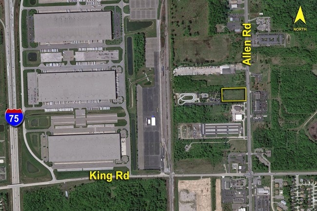
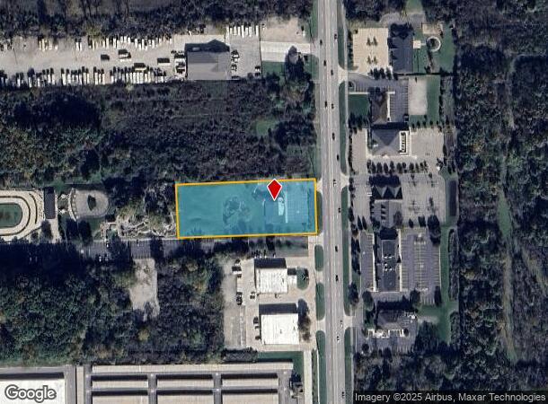
Property Record
19636 Allen Rd, Brownstown Twp, MI 48183
NEARBY LISTINGS FOR SALE OR LEASE
Property Detail
19636 Allen Rd
Detroit-Warren-Dearborn, MI
Dawnshire Sub
70-034-99-0008-000
10Z1A T4S PT OF SE 1/4 OF SEC 10 T4SR10E BEG N 60.9FT FROM SE COR OF NE 1/4 OF SE 1/4 OF SEC 10 TH N 174.24FT TH W 500FT TH S 174.24 FT TH E 500FT POB EXC E 60FT 1.76 ACRES
Commercialnec
Wayne
X
Michigan
26163C0411E
1.76 AC
2024
Downriver South
2025
Detroit
591502
DEMOGRAPHICS near 19636 Allen Rd
1 Mile
3 Mile
5 Mile
2024 Total Population
3,232
59,653
149,653
2029 Population
3,089
57,164
143,527
Pop Growth 2024-2029
(4.42%)
(4.17%)
(4.09%)
Average Age
43
43
42
2024 Total Households
1,280
25,505
62,880
HH Growth 2024-2029
(4.22%)
(4.19%)
(4.12%)
Median Household Inc
$73,835
$70,034
$68,990
Avg Household Size
2.40
2.30
2.30
2024 Avg HH Vehicles
2.00
2.00
2.00
Median Home Value
$192,027
$190,019
$181,968
Median Year Built
1976
1971
1970
Nearby Places
Map Layers
Map Styles
 Street
 Aerial
- Restaurants
- Banks
- Shops
- Fitness
- Groceries
PUBLIC TRANSPORTATION
AIRPORT
Detroit Metro Wayne County
DRIVE
WALK
Distance
Detroit Metro Wayne County
24 min
12.4 mi
Windsor International
DRIVE
WALK
Distance
Windsor International
44 min
26.7 mi
Freight Ports
DRIVE
WALK
Distance
57 min
44.0 mi
Nearby Properties
Address
Land Use
TOTAL SIZE
Lot Size
Zoning
Address
Land Use
TOTAL SIZE
Lot Size
Zoning
2,651,867 SF
137.23 AC
I-3
Address
Land Use
TOTAL SIZE
Lot Size
Zoning
1,981,391 SF
166.35 AC
I-2
Address
Land Use
TOTAL SIZE
Lot Size
Zoning
1,606,527 SF
126.47 AC
I-2
Address
Land Use
TOTAL SIZE
Lot Size
Zoning
2,193,696 SF
182.23 AC
Address
Land Use
TOTAL SIZE
Lot Size
Zoning
235,489 SF
23.47 AC
Address
Land Use
TOTAL SIZE
Lot Size
Zoning
177,054 SF
11.88 AC
PUD
Address
Land Use
TOTAL SIZE
Lot Size
Zoning
131,205 SF
13.95 AC
B-2
Address
Land Use
TOTAL SIZE
Lot Size
Zoning
729,040 SF
45.85 AC
I-2
Address
Land Use
TOTAL SIZE
Lot Size
Zoning
150,224 SF
15.45 AC
RM-1
Address
Land Use
TOTAL SIZE
Lot Size
Zoning
125,898 SF
10.62 AC
B-2
Address
Land Use
TOTAL SIZE
Lot Size
Zoning
125,898 SF
10.62 AC
B-2
Address
Land Use
TOTAL SIZE
Lot Size
Zoning
247,238 SF
21.39 AC
I-1
Address
Land Use
TOTAL SIZE
Lot Size
Zoning
200,484 SF
48.86 AC
B-3
Address
Land Use
TOTAL SIZE
Lot Size
Zoning
35.50 AC
RM-1
Address
Land Use
TOTAL SIZE
Lot Size
Zoning
172,998 SF
17.91 AC
RM-1
Address
Land Use
TOTAL SIZE
Lot Size
Zoning
112,726 SF
21.10 AC
TC
Address
Land Use
TOTAL SIZE
Lot Size
Zoning
122,430 SF
22.24 AC
Address
Land Use
TOTAL SIZE
Lot Size
Zoning
209,221 SF
21.80 AC
Address
Land Use
TOTAL SIZE
Lot Size
Zoning
211,389 SF
41.38 AC
Address
Land Use
TOTAL SIZE
Lot Size
Zoning
42.98 AC
Address
Land Use
TOTAL SIZE
Lot Size
Zoning
252,833 SF
34.40 AC
RM1-MUL
Address
Land Use
TOTAL SIZE
Lot Size
Zoning
240,852 SF
15.44 AC
RM MULTI F
Address
Land Use
TOTAL SIZE
Lot Size
Zoning
203,114 SF
14.50 AC
R-M MUL
Address
Land Use
TOTAL SIZE
Lot Size
Zoning
178,682 SF
19.23 AC
Address
Land Use
TOTAL SIZE
Lot Size
Zoning
125,828 SF
8.17 AC
B-2 COM
Address
Land Use
TOTAL SIZE
Lot Size
Zoning
2,160 SF
334.88 AC
I1
Address
Land Use
TOTAL SIZE
Lot Size
Zoning
143,496 SF
3.73 AC
RM-2
Address
Land Use
TOTAL SIZE
Lot Size
Zoning
148,815 SF
9.11 AC
RM MULTI F
Address
Land Use
TOTAL SIZE
Lot Size
Zoning
202,349 SF
14.33 AC
RM MULTI F
Address
Land Use
TOTAL SIZE
Lot Size
Zoning
255,456 SF
7.74 AC
I-1
The World's #1 Commercial Real Estate Marketplace
Connect with us
© 2025 CoStar Group
The information above has been obtained from sources believed reliable. While we do not doubt its accuracy we have not verified it and make no guarantee, warranty or representation about it. It is your responsibility to independently confirm its accuracy and completeness. Any projections, opinions, assumptions, or estimates used are for example only and do not represent the current or future performance of the property. The value of this transaction to you depends on tax and other factors which should be evaluated by your tax, financial, and legal advisors. You and your advisors should conduct a careful, independent investigation of the property to determine to your satisfaction the suitability of the property for your needs.