Property Record
19647 River Bottom Rd, Katy, TX 77449
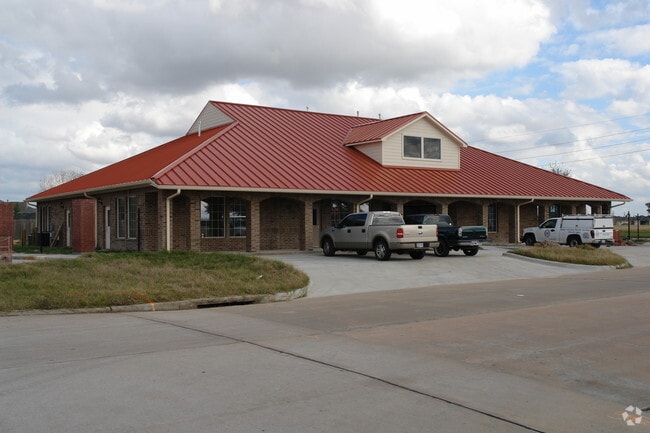

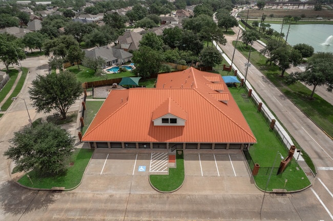
This Property Is For Sale
Property Detail
19647 River Bottom Rd
1230630020001
RES D BLK 2 BEAR CREEK MEADOWS SEC 1
Daycare
HARRIS
B and X Area of moderate flood hazard, usually the area between the limits of the 100-year and 500-year floods.
Texas
2024
0.56 AC
2025
Far Katy North
542106
Houston
9,022 SF
Houston-Pasadena-The Woodlands, TX
NEARBY LISTINGS FOR SALE OR LEASE
DEMOGRAPHICS near 19647 River Bottom Rd
1 mile
3 mile
5 mile
2025 Total Population
27,067
156,994
346,521
2030 Population
28,613
167,299
369,971
Pop Growth 2025-2030
+ 5.71%
+ 6.56%
+ 6.77%
Average Age
33
35
36
2025 Total Households
7,841
46,237
107,269
HH Growth 2025-2030
+ 5.92%
+ 6.73%
+ 6.93%
Median Household Inc
$83,924
$90,487
$94,754
Avg Household Size
3.40
3.30
3.20
2025 Avg HH Vehicles
2.00
2.00
2.00
Median Home Value
$244,495
$271,177
$285,307
Median Year Built
2006
2005
2003
Nearby Places
Map Layers
Map Styles
 Street
 Aerial
Layers
 Traffic
 Biking
Places
Listings with unknown addresses are not visible on the map
- Restaurants
- Banks
- Shops
- Fitness
- Groceries
PUBLIC TRANSPORTATION
AIRPORT
George Bush Intcntl/Houston
Drive
Walk
Distance
George Bush Intcntl/Houston
43 min
28.9 mi
William P Hobby
Drive
Walk
Distance
William P Hobby
61 min
40.2 mi
Nearby Properties
Address
Land Use
TOTAL SIZE
Lot Size
Zoning
Address
Land Use
TOTAL SIZE
Lot Size
Zoning
355,721 SF
13 AC
Address
Land Use
TOTAL SIZE
Lot Size
Zoning
323,609 SF
12.71 AC
Address
Land Use
TOTAL SIZE
Lot Size
Zoning
335,899 SF
12.62 AC
Address
Land Use
TOTAL SIZE
Lot Size
Zoning
331,263 SF
11.36 AC
Address
Land Use
TOTAL SIZE
Lot Size
Zoning
320,084 SF
8.01 AC
Address
Land Use
TOTAL SIZE
Lot Size
Zoning
236,406 SF
11.40 AC
Address
Land Use
TOTAL SIZE
Lot Size
Zoning
418,572 SF
24.76 AC
Address
Land Use
TOTAL SIZE
Lot Size
Zoning
262,174 SF
11.64 AC
Address
Land Use
TOTAL SIZE
Lot Size
Zoning
267,766 SF
12.96 AC
Address
Land Use
TOTAL SIZE
Lot Size
Zoning
290,927 SF
14.53 AC
Address
Land Use
TOTAL SIZE
Lot Size
Zoning
147,923 SF
11.60 AC
Address
Land Use
TOTAL SIZE
Lot Size
Zoning
262,048 SF
7 AC
Address
Land Use
TOTAL SIZE
Lot Size
Zoning
131,152 SF
7.14 AC
Address
Land Use
TOTAL SIZE
Lot Size
Zoning
171,000 SF
7.08 AC
Address
Land Use
TOTAL SIZE
Lot Size
Zoning
117,860 SF
12.44 AC
Address
Land Use
TOTAL SIZE
Lot Size
Zoning
204,129 SF
Address
Land Use
TOTAL SIZE
Lot Size
Zoning
193,160 SF
8.99 AC
Address
Land Use
TOTAL SIZE
Lot Size
Zoning
228,152 SF
22.61 AC
Address
Land Use
TOTAL SIZE
Lot Size
Zoning
122,880 SF
15 AC
Address
Land Use
TOTAL SIZE
Lot Size
Zoning
163,770 SF
5.08 AC
Address
Land Use
TOTAL SIZE
Lot Size
Zoning
192,903 SF
12.16 AC
Address
Land Use
TOTAL SIZE
Lot Size
Zoning
58,014 SF
22.85 AC
Address
Land Use
TOTAL SIZE
Lot Size
Zoning
84.23 AC
Address
Land Use
TOTAL SIZE
Lot Size
Zoning
52,035 SF
9.23 AC
Address
Land Use
TOTAL SIZE
Lot Size
Zoning
99,883 SF
3.16 AC
Address
Land Use
TOTAL SIZE
Lot Size
Zoning
83,750 SF
4.88 AC
Address
Land Use
TOTAL SIZE
Lot Size
Zoning
64,627 SF
4.37 AC
Address
Land Use
TOTAL SIZE
Lot Size
Zoning
126,890 SF
6.29 AC
Address
Land Use
TOTAL SIZE
Lot Size
Zoning
57,300 SF
7.89 AC
Address
Land Use
TOTAL SIZE
Lot Size
Zoning
66,891 SF
7.02 AC
The World's #1 Commercial Real Estate Marketplace
Connect with us
© 2026 CoStar Group
The information above has been obtained from sources believed reliable. While we do not doubt its accuracy we have not verified it and make no guarantee, warranty or representation about it. It is your responsibility to independently confirm its accuracy and completeness. Any projections, opinions, assumptions, or estimates used are for example only and do not represent the current or future performance of the property. The value of this transaction to you depends on tax and other factors which should be evaluated by your tax, financial, and legal advisors. You and your advisors should conduct a careful, independent investigation of the property to determine to your satisfaction the suitability of the property for your needs.