Property Record
19648 Xavier Ave, Granger, IA 50109
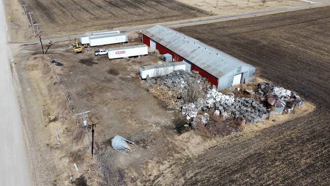

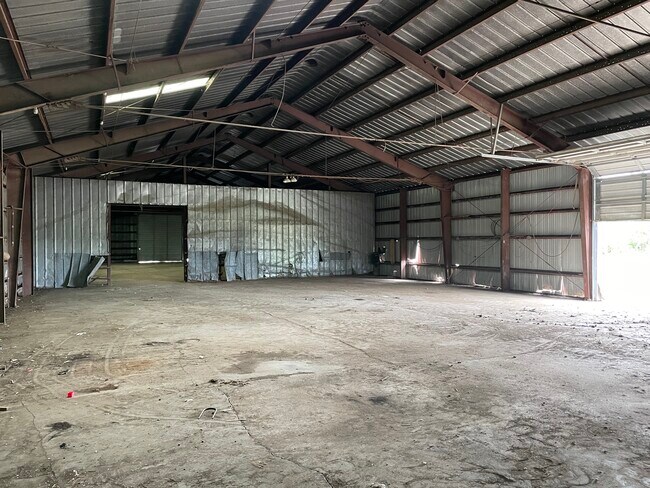
Property Detail
19648 Xavier Ave
08-12-400-002
PT NW SE
Warehouse
DALLAS
B and X Area of moderate flood hazard, usually the area between the limits of the 100-year and 500-year floods.
Iowa
2024
1.25 AC
2025
Outlying Dallas County
011500
Des Moines
8,000 SF
Des Moines-West Des Moines, IA
NEARBY LISTINGS FOR SALE OR LEASE
DEMOGRAPHICS near 19648 Xavier Ave
1 mile
3 mile
5 mile
2025 Total Population
1,532
3,969
18,461
2030 Population
1,694
4,352
19,787
Pop Growth 2025-2030
+ 10.57%
+ 9.65%
+ 7.18%
Average Age
39
39
36
2025 Total Households
540
1,399
6,428
HH Growth 2025-2030
+ 10.93%
+ 9.94%
+ 7.36%
Median Household Inc
$132,901
$132,002
$129,064
Avg Household Size
2.80
2.80
2.80
2025 Avg HH Vehicles
2.00
2.00
2.00
Median Home Value
$389,146
$382,327
$385,579
Median Year Built
2004
2003
2006
Nearby Places
Map Layers
Map Styles
 Street
 Aerial
Layers
 Traffic
 Biking
Places
Listings with unknown addresses are not visible on the map
- Restaurants
- Banks
- Shops
- Fitness
- Groceries
PUBLIC TRANSPORTATION
AIRPORT
Des Moines International
Drive
Walk
Distance
Des Moines International
36 min
23.4 mi
SALE & LEASE HISTORY
LISTING DATE
SALE/LEASE

Nov 15, 2021
For Lease
Jun 09, 2022
For Sale
Nearby Properties
Address
Land Use
TOTAL SIZE
Lot Size
Zoning
Address
Land Use
TOTAL SIZE
Lot Size
Zoning
2.44 AC
Address
Land Use
TOTAL SIZE
Lot Size
Zoning
8,100 SF
16.99 AC
Address
Land Use
TOTAL SIZE
Lot Size
Zoning
24,320 SF
4.14 AC
Address
Land Use
TOTAL SIZE
Lot Size
Zoning
3,402 SF
5.93 AC
Address
Land Use
TOTAL SIZE
Lot Size
Zoning
8,738 SF
29.38 AC
Address
Land Use
TOTAL SIZE
Lot Size
Zoning
3.46 AC
Address
Land Use
TOTAL SIZE
Lot Size
Zoning
24,300 SF
3.40 AC
Address
Land Use
TOTAL SIZE
Lot Size
Zoning
24,374 SF
11.99 AC
Address
Land Use
TOTAL SIZE
Lot Size
Zoning
2,750 SF
9.30 AC
Address
Land Use
TOTAL SIZE
Lot Size
Zoning
20,754 SF
4 AC
Address
Land Use
TOTAL SIZE
Lot Size
Zoning
9,120 SF
5.81 AC
Address
Land Use
TOTAL SIZE
Lot Size
Zoning
7,970 SF
2.87 AC
Address
Land Use
TOTAL SIZE
Lot Size
Zoning
2.65 AC
Address
Land Use
TOTAL SIZE
Lot Size
Zoning
20,480 SF
Address
Land Use
TOTAL SIZE
Lot Size
Zoning
3,362 SF
2.36 AC
Address
Land Use
TOTAL SIZE
Lot Size
Zoning
10,080 SF
15.34 AC
Address
Land Use
TOTAL SIZE
Lot Size
Zoning
3,024 SF
2.70 AC
Address
Land Use
TOTAL SIZE
Lot Size
Zoning
6,040 SF
0.91 AC
Address
Land Use
TOTAL SIZE
Lot Size
Zoning
2,880 SF
0.43 AC
Address
Land Use
TOTAL SIZE
Lot Size
Zoning
9,146 SF
0.71 AC
Address
Land Use
TOTAL SIZE
Lot Size
Zoning
9,146 SF
0.89 AC
Address
Land Use
TOTAL SIZE
Lot Size
Zoning
15,855 SF
1.46 AC
Address
Land Use
TOTAL SIZE
Lot Size
Zoning
2,800 SF
1.40 AC
Address
Land Use
TOTAL SIZE
Lot Size
Zoning
17,250 SF
1 AC
Address
Land Use
TOTAL SIZE
Lot Size
Zoning
5,152 SF
4.10 AC
Address
Land Use
TOTAL SIZE
Lot Size
Zoning
10,240 SF
0.39 AC
Address
Land Use
TOTAL SIZE
Lot Size
Zoning
4,550 SF
2.42 AC
Address
Land Use
TOTAL SIZE
Lot Size
Zoning
14,500 SF
0.44 AC
The World's #1 Commercial Real Estate Marketplace
Connect with us
© 2026 CoStar Group
The information above has been obtained from sources believed reliable. While we do not doubt its accuracy we have not verified it and make no guarantee, warranty or representation about it. It is your responsibility to independently confirm its accuracy and completeness. Any projections, opinions, assumptions, or estimates used are for example only and do not represent the current or future performance of the property. The value of this transaction to you depends on tax and other factors which should be evaluated by your tax, financial, and legal advisors. You and your advisors should conduct a careful, independent investigation of the property to determine to your satisfaction the suitability of the property for your needs.