Property Record
1965 Bees Ferry Rd, Charleston, SC 29414
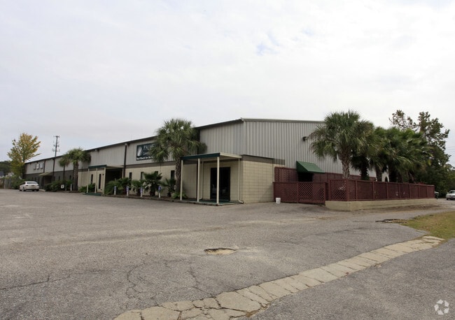
Property Detail
1965 Bees Ferry Rd
Charleston-North Charleston, SC
SUBDIVISION NAME -HICKORY HILLS INDUSTRIAL PARK DESCRIPTION -LOT 2
356-00-00-033
Charleston
Commercialnec
South Carolina
C and X Area of minimal flood hazard, usually depicted on FIRMs as above the 500-year flood level.
2
2025
1.38 AC
2024
West Ashley
005602
Charleston/N Charleston
8,945 SF
NEARBY LISTINGS FOR SALE OR LEASE
DEMOGRAPHICS near 1965 Bees Ferry Rd
1 mile
3 mile
5 mile
2025 Total Population
5,412
52,694
98,253
2030 Population
5,552
54,443
101,806
Pop Growth 2025-2030
+ 2.59%
+ 3.32%
+ 3.62%
Average Age
41
40
40
2025 Total Households
2,306
23,098
42,668
HH Growth 2025-2030
+ 2.69%
+ 3.40%
+ 3.64%
Median Household Inc
$107,291
$90,855
$82,726
Avg Household Size
2.30
2.20
2.20
2025 Avg HH Vehicles
2.00
2.00
2.00
Median Home Value
$413,648
$393,970
$380,237
Median Year Built
1996
1997
1987
Nearby Places
Map Layers
Map Styles
 Street
 Aerial
Layers
 Traffic
 Biking
Places
Listings with unknown addresses are not visible on the map
- Restaurants
- Banks
- Shops
- Fitness
- Groceries
PUBLIC TRANSPORTATION
AIRPORT
Charleston AFB/International
Drive
Walk
Distance
Charleston AFB/International
20 min
12.8 mi
Freight Ports
Veterans Terminal
Drive
Walk
Distance
Veterans Terminal
21 min
11.9 mi
Nearby Properties
Address
Land Use
TOTAL SIZE
Lot Size
Zoning
Address
Land Use
TOTAL SIZE
Lot Size
Zoning
9,778 SF
11.90 AC
Address
Land Use
TOTAL SIZE
Lot Size
Zoning
Address
Land Use
TOTAL SIZE
Lot Size
Zoning
11,631 SF
8 AC
Address
Land Use
TOTAL SIZE
Lot Size
Zoning
17,271 SF
3.65 AC
Address
Land Use
TOTAL SIZE
Lot Size
Zoning
6,036 SF
8.79 AC
Address
Land Use
TOTAL SIZE
Lot Size
Zoning
5.54 AC
Address
Land Use
TOTAL SIZE
Lot Size
Zoning
3,275 SF
4.18 AC
Address
Land Use
TOTAL SIZE
Lot Size
Zoning
6,531 SF
3.11 AC
Address
Land Use
TOTAL SIZE
Lot Size
Zoning
56.56 AC
Address
Land Use
TOTAL SIZE
Lot Size
Zoning
Address
Land Use
TOTAL SIZE
Lot Size
Zoning
5,421 SF
22.92 AC
Address
Land Use
TOTAL SIZE
Lot Size
Zoning
17,550 SF
24.36 AC
Address
Land Use
TOTAL SIZE
Lot Size
Zoning
13.30 AC
Address
Land Use
TOTAL SIZE
Lot Size
Zoning
Address
Land Use
TOTAL SIZE
Lot Size
Zoning
Address
Land Use
TOTAL SIZE
Lot Size
Zoning
75,984 SF
2.15 AC
Address
Land Use
TOTAL SIZE
Lot Size
Zoning
11,300 SF
25.42 AC
Address
Land Use
TOTAL SIZE
Lot Size
Zoning
Address
Land Use
TOTAL SIZE
Lot Size
Zoning
7,492 SF
9.54 AC
Address
Land Use
TOTAL SIZE
Lot Size
Zoning
8,922 SF
27.21 AC
Address
Land Use
TOTAL SIZE
Lot Size
Zoning
5,632 SF
16.98 AC
Address
Land Use
TOTAL SIZE
Lot Size
Zoning
7,900 SF
16.38 AC
Address
Land Use
TOTAL SIZE
Lot Size
Zoning
Address
Land Use
TOTAL SIZE
Lot Size
Zoning
146.70 AC
Address
Land Use
TOTAL SIZE
Lot Size
Zoning
4,060 SF
27.84 AC
Address
Land Use
TOTAL SIZE
Lot Size
Zoning
22,578 SF
23.54 AC
Address
Land Use
TOTAL SIZE
Lot Size
Zoning
Address
Land Use
TOTAL SIZE
Lot Size
Zoning
14.07 AC
Address
Land Use
TOTAL SIZE
Lot Size
Zoning
35.14 AC
Address
Land Use
TOTAL SIZE
Lot Size
Zoning
The World's #1 Commercial Real Estate Marketplace
Connect with us
© 2026 CoStar Group
The information above has been obtained from sources believed reliable. While we do not doubt its accuracy we have not verified it and make no guarantee, warranty or representation about it. It is your responsibility to independently confirm its accuracy and completeness. Any projections, opinions, assumptions, or estimates used are for example only and do not represent the current or future performance of the property. The value of this transaction to you depends on tax and other factors which should be evaluated by your tax, financial, and legal advisors. You and your advisors should conduct a careful, independent investigation of the property to determine to your satisfaction the suitability of the property for your needs.