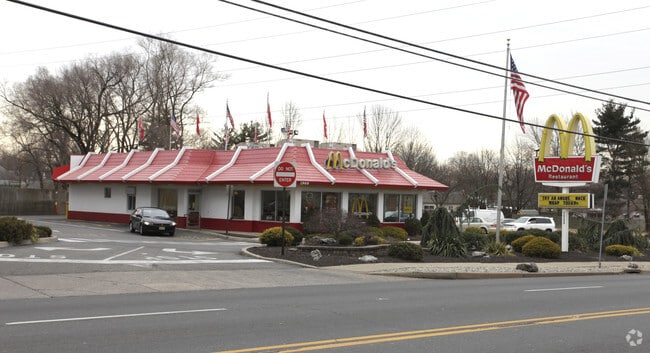
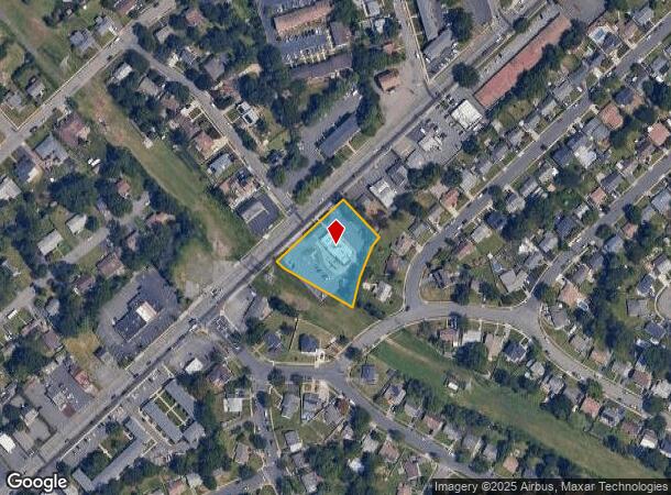
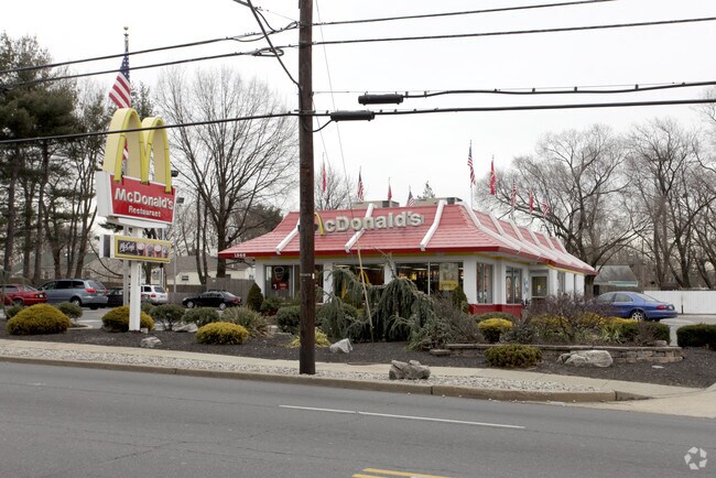
Property Record
1968 State Route 27, Edison, NJ 08817
NEARBY LISTINGS FOR SALE OR LEASE
Property Detail
1968 State Route 27
Lakewood-New Brunswick, NJ
200X147+TRI
05-01131-0000-00031
Middlesex
Restaurantdrivein
New Jersey
X
31
34023C0044F
0.68 AC
2024
South Edison
2025
Northern New Jersey
001701
DEMOGRAPHICS near 1968 State Route 27
1 Mile
3 Mile
5 Mile
2024 Total Population
16,123
107,277
296,198
2029 Population
16,047
106,591
294,565
Pop Growth 2024-2029
(0.47%)
(0.64%)
(0.55%)
Average Age
39
39
38
2024 Total Households
5,496
38,543
99,268
HH Growth 2024-2029
(0.55%)
(0.72%)
(0.48%)
Median Household Inc
$104,104
$108,193
$100,152
Avg Household Size
2.80
2.70
2.80
2024 Avg HH Vehicles
2.00
2.00
2.00
Median Home Value
$364,333
$421,332
$397,111
Median Year Built
1959
1970
1968
Nearby Places
Map Layers
Map Styles
 Street
 Aerial
- Restaurants
- Banks
- Shops
- Fitness
- Groceries
PUBLIC TRANSPORTATION
COMMUTER RAIL
Edison (Northeast Corridor Line - NJ Transit Commuter Rail (NJ Transit))
DRIVE
WALK
Distance
Edison (Northeast Corridor Line - NJ Transit Commuter Rail (NJ Transit))
4 min
1.3 mi
Metuchen (Northeast Corridor Line - NJ Transit Commuter Rail (NJ Transit))
DRIVE
WALK
Distance
Metuchen (Northeast Corridor Line - NJ Transit Commuter Rail (NJ Transit))
7 min
2.7 mi
AIRPORT
Newark Liberty International
DRIVE
WALK
Distance
Newark Liberty International
34 min
23.9 mi
Trenton Mercer
DRIVE
WALK
Distance
Trenton Mercer
49 min
31.8 mi
LaGuardia
DRIVE
WALK
Distance
LaGuardia
66 min
41.2 mi
Freight Ports
New York Container Terminal
DRIVE
WALK
Distance
New York Container Terminal
28 min
19.0 mi
SALE & LEASE HISTORY
LISTING DATE
SALE/LEASE

Apr 13, 2018
For Lease
Nearby Properties
Address
Land Use
TOTAL SIZE
Lot Size
Zoning
Address
Land Use
TOTAL SIZE
Lot Size
Zoning
138,550 SF
104.63 AC
E
Address
Land Use
TOTAL SIZE
Lot Size
Zoning
17 AC
O-1
Address
Land Use
TOTAL SIZE
Lot Size
Zoning
Address
Land Use
TOTAL SIZE
Lot Size
Zoning
52,074 SF
68.14 AC
E
Address
Land Use
TOTAL SIZE
Lot Size
Zoning
23,140 SF
107.63 AC
E
Address
Land Use
TOTAL SIZE
Lot Size
Zoning
165.43 AC
EI
Address
Land Use
TOTAL SIZE
Lot Size
Zoning
6,495 SF
5.74 AC
IN-1
Address
Land Use
TOTAL SIZE
Lot Size
Zoning
5.54 AC
C-5
Address
Land Use
TOTAL SIZE
Lot Size
Zoning
147.45 AC
RRRD
Address
Land Use
TOTAL SIZE
Lot Size
Zoning
137.89 AC
RAA
Address
Land Use
TOTAL SIZE
Lot Size
Zoning
11.44 AC
Address
Land Use
TOTAL SIZE
Lot Size
Zoning
49.83 AC
LI
Address
Land Use
TOTAL SIZE
Lot Size
Zoning
4,600 SF
33.13 AC
IN-2
Address
Land Use
TOTAL SIZE
Lot Size
Zoning
33,251 SF
6.42 AC
O-1
Address
Land Use
TOTAL SIZE
Lot Size
Zoning
103,973 SF
51.10 AC
LI1
Address
Land Use
TOTAL SIZE
Lot Size
Zoning
55.57 AC
LI
Address
Land Use
TOTAL SIZE
Lot Size
Zoning
12,800 SF
17.08 AC
R-6
Address
Land Use
TOTAL SIZE
Lot Size
Zoning
40.78 AC
RRRD
Address
Land Use
TOTAL SIZE
Lot Size
Zoning
11.21 AC
.
Address
Land Use
TOTAL SIZE
Lot Size
Zoning
50.50 AC
LI
Address
Land Use
TOTAL SIZE
Lot Size
Zoning
9.81 AC
RMG
Address
Land Use
TOTAL SIZE
Lot Size
Zoning
12.43 AC
RMG
Address
Land Use
TOTAL SIZE
Lot Size
Zoning
118.40 AC
LI
Address
Land Use
TOTAL SIZE
Lot Size
Zoning
4,815 SF
6.68 AC
IN-1
Address
Land Use
TOTAL SIZE
Lot Size
Zoning
8,280 SF
1.12 AC
R-6
Address
Land Use
TOTAL SIZE
Lot Size
Zoning
1.99 AC
C-4
Address
Land Use
TOTAL SIZE
Lot Size
Zoning
0.21 AC
LR
Address
Land Use
TOTAL SIZE
Lot Size
Zoning
6.60 AC
RMG
Address
Land Use
TOTAL SIZE
Lot Size
Zoning
35.98 AC
LI
Address
Land Use
TOTAL SIZE
Lot Size
Zoning
16,734 SF
9.37 AC
RM
The World's #1 Commercial Real Estate Marketplace
Connect with us
© 2026 CoStar Group
The information above has been obtained from sources believed reliable. While we do not doubt its accuracy we have not verified it and make no guarantee, warranty or representation about it. It is your responsibility to independently confirm its accuracy and completeness. Any projections, opinions, assumptions, or estimates used are for example only and do not represent the current or future performance of the property. The value of this transaction to you depends on tax and other factors which should be evaluated by your tax, financial, and legal advisors. You and your advisors should conduct a careful, independent investigation of the property to determine to your satisfaction the suitability of the property for your needs.