Property Record
19591 W Indian School Rd, Buckeye, AZ 85396
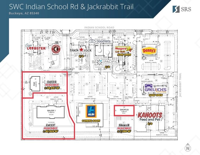
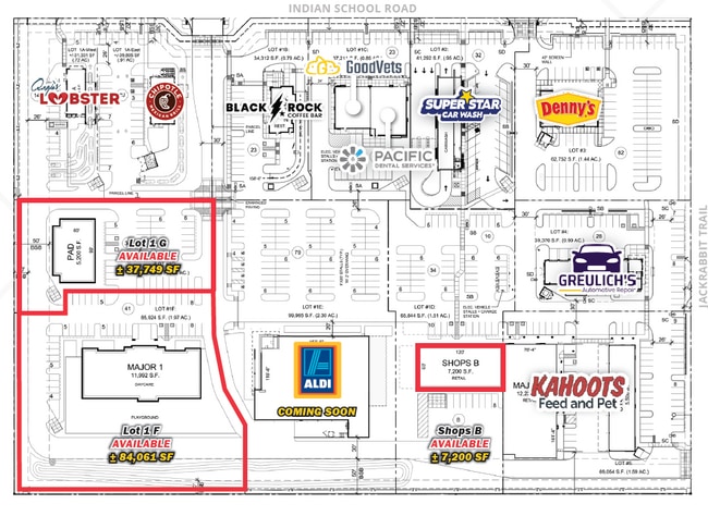
Current Lease Availabilities
NEARBY LISTINGS FOR SALE OR LEASE
Property Detail
19591 W Indian School Rd
Phoenix
Jackrabbit Crossing Mld
Phoenix-Mesa-Scottsdale, AZ
JACKRABBIT CROSSING MLD MCR 1602-25
502-62-225A
Maricopa
Commercialacreage
Arizona
2024
1
2025
9.94 AC
050620
North Buckeye
8,696 SF
DEMOGRAPHICS near 19591 W Indian School Rd
1 Mile
3 Mile
5 Mile
2024 Total Population
5,890
41,709
90,424
2029 Population
6,843
47,042
101,054
Pop Growth 2024-2029
+ 16.18%
+ 12.79%
+ 11.76%
Average Age
40
39
40
2024 Total Households
1,847
13,349
29,741
HH Growth 2024-2029
+ 16.35%
+ 13.09%
+ 12.01%
Median Household Inc
$134,492
$123,902
$105,126
Avg Household Size
3.10
3.10
3.00
2024 Avg HH Vehicles
3.00
3.00
2.00
Median Home Value
$473,144
$477,428
$432,637
Median Year Built
2010
2010
2010
Nearby Places
- Restaurants
- Banks
- Shops
- Fitness
- Groceries
PUBLIC TRANSPORTATION
AIRPORT
Phoenix Sky Harbor International
DRIVE
WALK
Distance
Phoenix Sky Harbor International
42 min
31.9 mi
Nearby Properties
Address
Land Use
TOTAL SIZE
Lot Size
Zoning
Address
Land Use
TOTAL SIZE
Lot Size
Zoning
551,831 SF
609.49 AC
AG
Address
Land Use
TOTAL SIZE
Lot Size
Zoning
196,353 SF
13.05 AC
C-C
Address
Land Use
TOTAL SIZE
Lot Size
Zoning
438,256 SF
48.59 AC
Address
Land Use
TOTAL SIZE
Lot Size
Zoning
244,676 SF
131.34 AC
Address
Land Use
TOTAL SIZE
Lot Size
Zoning
721,156 SF
44.90 AC
PAD
Address
Land Use
TOTAL SIZE
Lot Size
Zoning
166,213 SF
29.60 AC
PAD
Address
Land Use
TOTAL SIZE
Lot Size
Zoning
231,044 SF
48.70 AC
Address
Land Use
TOTAL SIZE
Lot Size
Zoning
249,623 SF
50.12 AC
PAD
Address
Land Use
TOTAL SIZE
Lot Size
Zoning
185,251 SF
13.29 AC
PAD
Address
Land Use
TOTAL SIZE
Lot Size
Zoning
152,901 SF
22.52 AC
Address
Land Use
TOTAL SIZE
Lot Size
Zoning
269,708 SF
15.51 AC
C2
Address
Land Use
TOTAL SIZE
Lot Size
Zoning
Address
Land Use
TOTAL SIZE
Lot Size
Zoning
108,281 SF
11.95 AC
PC
Address
Land Use
TOTAL SIZE
Lot Size
Zoning
12,418 SF
54.25 AC
PC
Address
Land Use
TOTAL SIZE
Lot Size
Zoning
80,531 SF
7.51 AC
PAD
Address
Land Use
TOTAL SIZE
Lot Size
Zoning
40,300 SF
19.53 AC
CC
Address
Land Use
TOTAL SIZE
Lot Size
Zoning
5,597 SF
164.45 AC
PR
Address
Land Use
TOTAL SIZE
Lot Size
Zoning
64,720 SF
2.24 AC
PC
Address
Land Use
TOTAL SIZE
Lot Size
Zoning
34,356 SF
14.43 AC
CC
Address
Land Use
TOTAL SIZE
Lot Size
Zoning
38,713 SF
7.12 AC
PAD
Address
Land Use
TOTAL SIZE
Lot Size
Zoning
51,512 SF
18.71 AC
I-1
Address
Land Use
TOTAL SIZE
Lot Size
Zoning
65,506 SF
5 AC
C-C
Address
Land Use
TOTAL SIZE
Lot Size
Zoning
52.66 AC
Address
Land Use
TOTAL SIZE
Lot Size
Zoning
616.15 AC
AG
Address
Land Use
TOTAL SIZE
Lot Size
Zoning
3,976 SF
1.38 AC
R-43
Address
Land Use
TOTAL SIZE
Lot Size
Zoning
31,223 SF
14.39 AC
C-C
Address
Land Use
TOTAL SIZE
Lot Size
Zoning
83,200 SF
1.25 AC
PC
The World's #1 Commercial Real Estate Marketplace
Connect with us
© 2025 CoStar Group
The information above has been obtained from sources believed reliable. While we do not doubt its accuracy we have not verified it and make no guarantee, warranty or representation about it. It is your responsibility to independently confirm its accuracy and completeness. Any projections, opinions, assumptions, or estimates used are for example only and do not represent the current or future performance of the property. The value of this transaction to you depends on tax and other factors which should be evaluated by your tax, financial, and legal advisors. You and your advisors should conduct a careful, independent investigation of the property to determine to your satisfaction the suitability of the property for your needs.