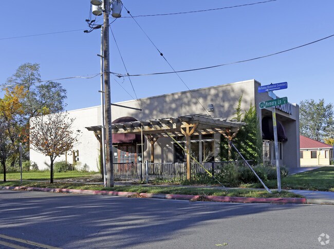
Property Record
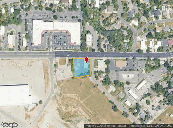
1968 E Murray Rd, Holladay, UT 84117
NEARBY LISTINGS FOR SALE OR LEASE
Property Detail
1968 E Murray Rd
22-09-228-004-0000
BEG W 104.37 FT & S 697.6 FT FR NE COR SEC 9, T 2S, R 1E, S L M; S 164.28 FT; S 79^1140 W 175.82 FT; N 2^59 W 198.15 FT; S 89^48 E 183.01 FT TO BEG. 0.74 AC 4159-0155 9307-9174,9195,9197 9438-8295 9307-9202 10232-2247 10232-2250,8859,8862 10391-4491
Storebuilding
Salt Lake
X
Utah
49035C0312G
m
2024
0.74 AC
2025
Central Valley East
111106
Salt Lake City
6,040 SF
Salt Lake City-Murray, UT
DEMOGRAPHICS near 1968 E Murray Rd
1 mile
3 mile
5 mile
2024 Total Population
14,783
122,601
287,387
2029 Population
14,933
123,524
290,142
Pop Growth 2024-2029
+ 1.01%
+ 0.75%
+ 0.96%
Average Age
41
40
39
2024 Total Households
5,795
48,458
113,669
HH Growth 2024-2029
+ 0.98%
+ 0.67%
+ 0.95%
Median Household Inc
$83,056
$81,223
$78,027
Avg Household Size
2.50
2.50
2.40
2024 Avg HH Vehicles
2.00
2.00
2.00
Median Home Value
$711,687
$585,777
$514,514
Median Year Built
1971
1972
1974
Nearby Places
Map Layers
Map Styles
 Street
 Aerial
Transit
 Traffic
 Biking
Places
Listings with unknown addresses are not visible on the map
- Restaurants
- Banks
- Shops
- Fitness
- Groceries
PUBLIC TRANSPORTATION
AIRPORT
Salt Lake City International
Drive
Walk
Distance
Salt Lake City International
23 min
15.4 mi
Provo Municipal
Drive
Walk
Distance
Provo Municipal
53 min
43.0 mi
Nearby Properties
Address
Land Use
TOTAL SIZE
Lot Size
Zoning
Address
Land Use
TOTAL SIZE
Lot Size
Zoning
2,024,859 SF
63 AC
C D C
Address
Land Use
TOTAL SIZE
Lot Size
Zoning
207,140 SF
23.06 AC
P
Address
Land Use
TOTAL SIZE
Lot Size
Zoning
257,003 SF
25.87 AC
1108
Address
Land Use
TOTAL SIZE
Lot Size
Zoning
691,463 SF
17.80 AC
RM
Address
Land Use
TOTAL SIZE
Lot Size
Zoning
251,867 SF
25.66 AC
H
Address
Land Use
TOTAL SIZE
Lot Size
Zoning
524,108 SF
34.46 AC
RM
Address
Land Use
TOTAL SIZE
Lot Size
Zoning
302,944 SF
5.47 AC
Address
Land Use
TOTAL SIZE
Lot Size
Zoning
369,717 SF
2.50 AC
RO
Address
Land Use
TOTAL SIZE
Lot Size
Zoning
412,006 SF
1.70 AC
C3
Address
Land Use
TOTAL SIZE
Lot Size
Zoning
179,702 SF
16.99 AC
1108
Address
Land Use
TOTAL SIZE
Lot Size
Zoning
225,849 SF
16.36 AC
RM-ZC
Address
Land Use
TOTAL SIZE
Lot Size
Zoning
21,057 SF
17.96 AC
RM20
Address
Land Use
TOTAL SIZE
Lot Size
Zoning
125,518 SF
11.03 AC
RMZC
Address
Land Use
TOTAL SIZE
Lot Size
Zoning
371,607 SF
10.77 AC
A-1
Address
Land Use
TOTAL SIZE
Lot Size
Zoning
33,164 SF
6.88 AC
RM
Address
Land Use
TOTAL SIZE
Lot Size
Zoning
37,563 SF
15.34 AC
RM20
Address
Land Use
TOTAL SIZE
Lot Size
Zoning
630,648 SF
3.22 AC
RO
Address
Land Use
TOTAL SIZE
Lot Size
Zoning
28,078 SF
15.33 AC
RM-10
Address
Land Use
TOTAL SIZE
Lot Size
Zoning
241,418 SF
8.84 AC
ORD
Address
Land Use
TOTAL SIZE
Lot Size
Zoning
444,836 SF
0.01 AC
RO
Address
Land Use
TOTAL SIZE
Lot Size
Zoning
299,673 SF
2.16 AC
C3
Address
Land Use
TOTAL SIZE
Lot Size
Zoning
83,204 SF
12.87 AC
RM
Address
Land Use
TOTAL SIZE
Lot Size
Zoning
412,477 SF
0.01 AC
R/M-U
Address
Land Use
TOTAL SIZE
Lot Size
Zoning
126,900 SF
0.38 AC
1108
Address
Land Use
TOTAL SIZE
Lot Size
Zoning
382,939 SF
5.70 AC
PDD-1
Address
Land Use
TOTAL SIZE
Lot Size
Zoning
99,702 SF
12.73 AC
R-M
Address
Land Use
TOTAL SIZE
Lot Size
Zoning
84,246 SF
6.51 AC
RM
Address
Land Use
TOTAL SIZE
Lot Size
Zoning
317,495 SF
2.75 AC
O-R-D
Address
Land Use
TOTAL SIZE
Lot Size
Zoning
77,051 SF
8.34 AC
RM/ZC
Address
Land Use
TOTAL SIZE
Lot Size
Zoning
63,922 SF
7.96 AC
RM
The World's #1 Commercial Real Estate Marketplace
Connect with us
© 2026 CoStar Group
The information above has been obtained from sources believed reliable. While we do not doubt its accuracy we have not verified it and make no guarantee, warranty or representation about it. It is your responsibility to independently confirm its accuracy and completeness. Any projections, opinions, assumptions, or estimates used are for example only and do not represent the current or future performance of the property. The value of this transaction to you depends on tax and other factors which should be evaluated by your tax, financial, and legal advisors. You and your advisors should conduct a careful, independent investigation of the property to determine to your satisfaction the suitability of the property for your needs.