Property Record
19685 Interstate 37 S, Elmendorf, TX 78112


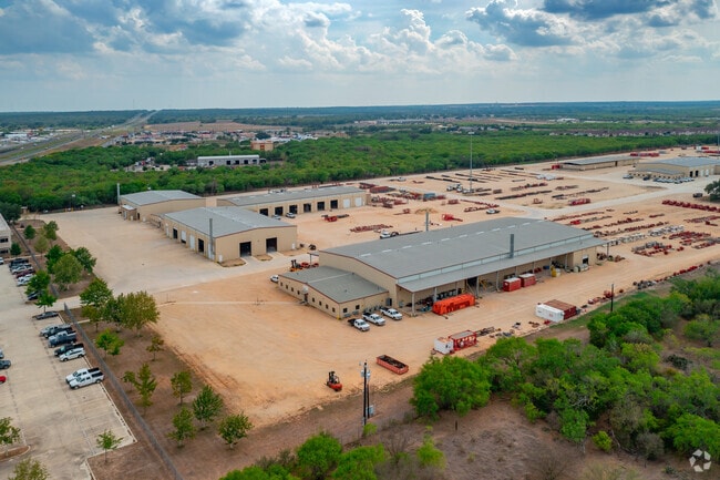

Property Detail
19685 Interstate 37 S
San Antonio-New Braunfels, TX
CB 4136E BLK 1 LOT 13 (WEATHERFORD HILLTOP) 2013 NEW ACCT PER PLAT 9645/143-151 EXE 9/7/12
04136-501-0130
BEXAR
Heavyindustrial
Texas
A Areas with a 1% annual chance of flooding and a 26% chance of flooding over the life of a 30-year mortgage.
13
2024
108.81 AC
2025
South
152201
San Antonio
226,474 SF
NEARBY LISTINGS FOR SALE OR LEASE
-
-
View all Elmendorf listings for sale on LoopNet.com
DEMOGRAPHICS near 19685 Interstate 37 S
1 mile
3 mile
5 mile
2025 Total Population
706
6,185
21,002
2030 Population
754
6,644
22,749
Pop Growth 2025-2030
+ 6.80%
+ 7.42%
+ 8.32%
Average Age
36
36
37
2025 Total Households
227
1,854
6,364
HH Growth 2025-2030
+ 7.05%
+ 7.50%
+ 8.41%
Median Household Inc
$73,194
$54,130
$60,405
Avg Household Size
3.00
3.30
3.20
2025 Avg HH Vehicles
2.00
2.00
2.00
Median Home Value
$130,882
$159,983
$175,735
Median Year Built
2006
1999
1999
Nearby Places
Map Layers
Map Styles
 Street
 Aerial
Layers
 Traffic
 Biking
Places
Listings with unknown addresses are not visible on the map
- Restaurants
- Banks
- Shops
- Fitness
- Groceries
PUBLIC TRANSPORTATION
AIRPORT
San Antonio International
Drive
Walk
Distance
San Antonio International
30 min
24.8 mi
Freight Ports
Port of Corpus Christi
Drive
Walk
Distance
Port of Corpus Christi
130 min
127.0 mi
Nearby Properties
Address
Land Use
TOTAL SIZE
Lot Size
Zoning
Address
Land Use
TOTAL SIZE
Lot Size
Zoning
211,505 SF
21.04 AC
Address
Land Use
TOTAL SIZE
Lot Size
Zoning
2,451,718 SF
148.17 AC
Address
Land Use
TOTAL SIZE
Lot Size
Zoning
57,863 SF
36.23 AC
Address
Land Use
TOTAL SIZE
Lot Size
Zoning
300.90 AC
Address
Land Use
TOTAL SIZE
Lot Size
Zoning
1,890 SF
361.85 AC
Address
Land Use
TOTAL SIZE
Lot Size
Zoning
485.17 AC
Address
Land Use
TOTAL SIZE
Lot Size
Zoning
298.72 AC
Address
Land Use
TOTAL SIZE
Lot Size
Zoning
116,731 SF
9.22 AC
Address
Land Use
TOTAL SIZE
Lot Size
Zoning
1,056 SF
304.42 AC
Address
Land Use
TOTAL SIZE
Lot Size
Zoning
47,314 SF
4.53 AC
Address
Land Use
TOTAL SIZE
Lot Size
Zoning
136.35 AC
Address
Land Use
TOTAL SIZE
Lot Size
Zoning
1,216 SF
500 AC
Address
Land Use
TOTAL SIZE
Lot Size
Zoning
153.39 AC
Address
Land Use
TOTAL SIZE
Lot Size
Zoning
43,005 SF
2.48 AC
Address
Land Use
TOTAL SIZE
Lot Size
Zoning
9,673,474 SF
8.35 AC
Address
Land Use
TOTAL SIZE
Lot Size
Zoning
19,623 SF
21.04 AC
Address
Land Use
TOTAL SIZE
Lot Size
Zoning
17,500 SF
6.77 AC
Address
Land Use
TOTAL SIZE
Lot Size
Zoning
29,105 SF
2.16 AC
Address
Land Use
TOTAL SIZE
Lot Size
Zoning
16,710 SF
4 AC
Address
Land Use
TOTAL SIZE
Lot Size
Zoning
420 SF
150 AC
Address
Land Use
TOTAL SIZE
Lot Size
Zoning
346,206 SF
2.99 AC
Address
Land Use
TOTAL SIZE
Lot Size
Zoning
21,562 SF
6.88 AC
Address
Land Use
TOTAL SIZE
Lot Size
Zoning
185.13 AC
Address
Land Use
TOTAL SIZE
Lot Size
Zoning
181.82 AC
Address
Land Use
TOTAL SIZE
Lot Size
Zoning
3,672 SF
2.16 AC
Address
Land Use
TOTAL SIZE
Lot Size
Zoning
222.49 AC
Address
Land Use
TOTAL SIZE
Lot Size
Zoning
3,183 SF
2.23 AC
Address
Land Use
TOTAL SIZE
Lot Size
Zoning
56,200 SF
2.90 AC
Address
Land Use
TOTAL SIZE
Lot Size
Zoning
784 SF
20.19 AC
The World's #1 Commercial Real Estate Marketplace
Connect with us
© 2026 CoStar Group
The information above has been obtained from sources believed reliable. While we do not doubt its accuracy we have not verified it and make no guarantee, warranty or representation about it. It is your responsibility to independently confirm its accuracy and completeness. Any projections, opinions, assumptions, or estimates used are for example only and do not represent the current or future performance of the property. The value of this transaction to you depends on tax and other factors which should be evaluated by your tax, financial, and legal advisors. You and your advisors should conduct a careful, independent investigation of the property to determine to your satisfaction the suitability of the property for your needs.