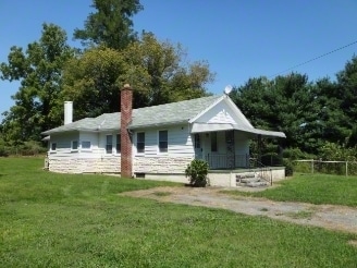
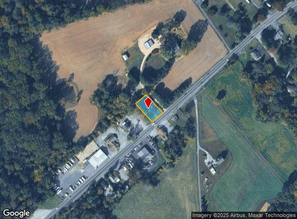
Property Record
197 Conowingo Rd, Conowingo, MD 21918
NEARBY LISTINGS FOR SALE OR LEASE
Property Detail
197 Conowingo Rd
08-000263
.32 ACRES 197 CONOWINGO ROAD KILBYS CORNER ROAD
Commercialofficeresidentialmixeduse
Cecil
X
Maryland
24025C0095E
25
2025
0.32 AC
2025
Cecil County
031400
Baltimore
1,274 SF
Philadelphia-Camden-Wilmington, PA-NJ-DE-MD
DEMOGRAPHICS near 197 Conowingo Rd
1 Mile
3 Mile
5 Mile
2024 Total Population
866
5,290
13,734
2029 Population
881
5,372
13,963
Pop Growth 2024-2029
+ 1.73%
+ 1.55%
+ 1.67%
Average Age
43
43
42
2024 Total Households
342
1,979
5,098
HH Growth 2024-2029
+ 1.75%
+ 1.62%
+ 1.79%
Median Household Inc
$71,656
$79,988
$82,769
Avg Household Size
2.50
2.60
2.60
2024 Avg HH Vehicles
2.00
2.00
2.00
Median Home Value
$283,504
$310,908
$318,159
Median Year Built
1987
1986
1983
Nearby Places
Map Layers
Map Styles
 Street
 Aerial
- Restaurants
- Banks
- Shops
- Fitness
- Groceries
Nearby Properties
Address
Land Use
TOTAL SIZE
Lot Size
Zoning
Address
Land Use
TOTAL SIZE
Lot Size
Zoning
7,384 SF
4,221.75 AC
GI AG
Address
Land Use
TOTAL SIZE
Lot Size
Zoning
45,575 SF
10.39 AC
RR
Address
Land Use
TOTAL SIZE
Lot Size
Zoning
3,460 SF
78.50 AC
MH
Address
Land Use
TOTAL SIZE
Lot Size
Zoning
12,240 SF
11.09 AC
B3GI
Address
Land Use
TOTAL SIZE
Lot Size
Zoning
1,928 SF
53.31 AC
MH
Address
Land Use
TOTAL SIZE
Lot Size
Zoning
15,737 SF
4.61 AC
BG
Address
Land Use
TOTAL SIZE
Lot Size
Zoning
4,775 SF
293.39 AC
NAR
Address
Land Use
TOTAL SIZE
Lot Size
Zoning
8,400 SF
160.19 AC
VB
Address
Land Use
TOTAL SIZE
Lot Size
Zoning
28.36 AC
MH
Address
Land Use
TOTAL SIZE
Lot Size
Zoning
11,470 SF
8.64 AC
VRB3
Address
Land Use
TOTAL SIZE
Lot Size
Zoning
9,060 SF
2.81 AC
BG
Address
Land Use
TOTAL SIZE
Lot Size
Zoning
960 SF
18.25 AC
B3 A1
Address
Land Use
TOTAL SIZE
Lot Size
Zoning
4,952 SF
2.50 AC
BG
Address
Land Use
TOTAL SIZE
Lot Size
Zoning
1,250 SF
100.18 AC
NAR
Address
Land Use
TOTAL SIZE
Lot Size
Zoning
2,532 SF
1.73 AC
RR
Address
Land Use
TOTAL SIZE
Lot Size
Zoning
4,000 SF
5.55 AC
NAR
Address
Land Use
TOTAL SIZE
Lot Size
Zoning
2,077 SF
2.18 AC
B3
Address
Land Use
TOTAL SIZE
Lot Size
Zoning
8,260 SF
3.24 AC
NAR
Address
Land Use
TOTAL SIZE
Lot Size
Zoning
5,288 SF
2.13 AC
BG
Address
Land Use
TOTAL SIZE
Lot Size
Zoning
6,400 SF
5.81 AC
RR
Address
Land Use
TOTAL SIZE
Lot Size
Zoning
7,755 SF
1.06 AC
BG
Address
Land Use
TOTAL SIZE
Lot Size
Zoning
2,008 SF
1.09 AC
BG
Address
Land Use
TOTAL SIZE
Lot Size
Zoning
2,536 SF
4 AC
RR
Address
Land Use
TOTAL SIZE
Lot Size
Zoning
2,760 SF
5.73 AC
SPLIT
Address
Land Use
TOTAL SIZE
Lot Size
Zoning
3,840 SF
2.86 AC
BG
Address
Land Use
TOTAL SIZE
Lot Size
Zoning
1,550 SF
0.93 AC
BG
Address
Land Use
TOTAL SIZE
Lot Size
Zoning
6,690 SF
0.80 AC
B1
Address
Land Use
TOTAL SIZE
Lot Size
Zoning
5,600 SF
2.84 AC
RR
Address
Land Use
TOTAL SIZE
Lot Size
Zoning
5,810 SF
0.90 AC
BG
Address
Land Use
TOTAL SIZE
Lot Size
Zoning
3,072 SF
3.05 AC
BL
The World's #1 Commercial Real Estate Marketplace
Connect with us
© 2026 CoStar Group
The information above has been obtained from sources believed reliable. While we do not doubt its accuracy we have not verified it and make no guarantee, warranty or representation about it. It is your responsibility to independently confirm its accuracy and completeness. Any projections, opinions, assumptions, or estimates used are for example only and do not represent the current or future performance of the property. The value of this transaction to you depends on tax and other factors which should be evaluated by your tax, financial, and legal advisors. You and your advisors should conduct a careful, independent investigation of the property to determine to your satisfaction the suitability of the property for your needs.