Property Record
197 Donovan Rd, Wrightsville, GA 31096
Save to a Folder
{{folder.Name}}
{{folder.ListingIds.length}} Properties
{{folder.ListingIds.length}} Property
Create a New Folder
Property Detail
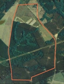
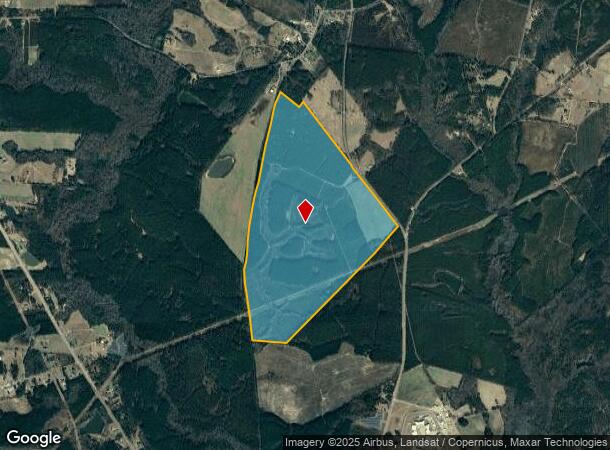
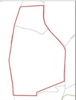
197 Donovan Rd
024-038
JOHNSON
Privatepreserveopenspacevacantlandforestlandconservation
Georgia
RURAL
357 AC
B and X Area of moderate flood hazard, usually the area between the limits of the 100-year and 500-year floods.
Georgia South Area
2025
Other Market Areas
2025
Dublin, GA
960202
NEARBY LISTINGS FOR SALE OR LEASE
-
-
View all Wrightsville listings for sale on LoopNet.com
DEMOGRAPHICS near 197 Donovan Rd
1 mile
3 mile
5 mile
2025 Total Population
54
2,155
4,155
2030 Population
54
2,145
4,130
Pop Growth 2025-2030
0.00%
(0.46%)
(0.60%)
Average Age
45
43
43
2025 Total Households
12
774
1,474
HH Growth 2025-2030
0.00%
(0.39%)
(0.68%)
Median Household Inc
$39,999
$38,726
$44,666
Avg Household Size
2.10
2.30
2.40
2025 Avg HH Vehicles
2.00
2.00
2.00
Median Home Value
$99,999
$84,229
$83,975
Median Year Built
1982
1981
1985
Nearby Places
Map Layers
Map Styles
 Street
 Aerial
Layers
 Traffic
 Biking
Places
Listings with unknown addresses are not visible on the map
- Restaurants
- Banks
- Shops
- Fitness
- Groceries
Nearby Properties
Address
Land Use
TOTAL SIZE
Lot Size
Zoning
Address
Land Use
TOTAL SIZE
Lot Size
Zoning
195,036 SF
46.96 AC
RESIDENTIA
Address
Land Use
TOTAL SIZE
Lot Size
Zoning
2,688 SF
5 AC
RESIDENTIA
Address
Land Use
TOTAL SIZE
Lot Size
Zoning
15,488 SF
3 AC
COMMERCIAL
Address
Land Use
TOTAL SIZE
Lot Size
Zoning
804 AC
UNZONED RU
Address
Land Use
TOTAL SIZE
Lot Size
Zoning
5,184 SF
21.25 AC
RURAL
Address
Land Use
TOTAL SIZE
Lot Size
Zoning
587 AC
RURAL
Address
Land Use
TOTAL SIZE
Lot Size
Zoning
14,051 SF
3.81 AC
RESIDENTIA
Address
Land Use
TOTAL SIZE
Lot Size
Zoning
5,792 SF
2.06 AC
COMMERCIAL
Address
Land Use
TOTAL SIZE
Lot Size
Zoning
24,222 SF
3.98 AC
COMMERCIAL
Address
Land Use
TOTAL SIZE
Lot Size
Zoning
11,253 SF
0.58 AC
UNZONED UR
Address
Land Use
TOTAL SIZE
Lot Size
Zoning
7,431 SF
0.70 AC
RURAL
Address
Land Use
TOTAL SIZE
Lot Size
Zoning
8,631 SF
UNZONED UR
Address
Land Use
TOTAL SIZE
Lot Size
Zoning
5,760 SF
1.37 AC
UNZONED UR
Address
Land Use
TOTAL SIZE
Lot Size
Zoning
306.34 AC
RURAL
Address
Land Use
TOTAL SIZE
Lot Size
Zoning
358.91 AC
RURAL
Address
Land Use
TOTAL SIZE
Lot Size
Zoning
21,988 SF
17.93 AC
RURAL
Address
Land Use
TOTAL SIZE
Lot Size
Zoning
286.60 AC
RURAL
Address
Land Use
TOTAL SIZE
Lot Size
Zoning
728 SF
363 AC
RESIDENTIA
Address
Land Use
TOTAL SIZE
Lot Size
Zoning
10,753 SF
4.87 AC
COMMERCIAL
Address
Land Use
TOTAL SIZE
Lot Size
Zoning
427.50 AC
RURAL
Address
Land Use
TOTAL SIZE
Lot Size
Zoning
288 AC
RURAL
Address
Land Use
TOTAL SIZE
Lot Size
Zoning
12,342 SF
0.44 AC
UNZONED UR
Address
Land Use
TOTAL SIZE
Lot Size
Zoning
980 SF
295.54 AC
RURAL
Address
Land Use
TOTAL SIZE
Lot Size
Zoning
7,700 SF
0.46 AC
COMMERCIAL
Address
Land Use
TOTAL SIZE
Lot Size
Zoning
275 AC
RURAL
Address
Land Use
TOTAL SIZE
Lot Size
Zoning
11,193 SF
1.21 AC
COMMERCIAL
Address
Land Use
TOTAL SIZE
Lot Size
Zoning
147.21 AC
RESIDENTIA
Address
Land Use
TOTAL SIZE
Lot Size
Zoning
9,016 SF
1.02 AC
UNZONED UR
Address
Land Use
TOTAL SIZE
Lot Size
Zoning
213.72 AC
RURAL
The World's #1 Commercial Real Estate Marketplace
Connect with us
© 2026 CoStar Group
The information above has been obtained from sources believed reliable. While we do not doubt its accuracy we have not verified it and make no guarantee, warranty or representation about it. It is your responsibility to independently confirm its accuracy and completeness. Any projections, opinions, assumptions, or estimates used are for example only and do not represent the current or future performance of the property. The value of this transaction to you depends on tax and other factors which should be evaluated by your tax, financial, and legal advisors. You and your advisors should conduct a careful, independent investigation of the property to determine to your satisfaction the suitability of the property for your needs.